
 United Kingdom
 France
 Germany
 Netherlands
 Sweden
 USA
USA
 Italy
Italy
 Spain
Spain
More From Contributor


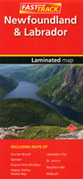
Newfoundland & Labrador FastTrack
Waterproof and tear-resistant FastTrack map presenting in a handy-size format a road map of Newfoundland with an enlargement of the Avalon and Bonavista Peninsulas and several street maps including St. John’s, plus coverage of Labrador, also accompanied by street maps.Newfoundland is presented on an indexed map at 1:1, 172, 000, with its south-eastern area of the Avalon and the Bonavista peninsulas also shown in greater detail at 1:550, 000. Road network indicates paved, gravel and unimproved roads with distances marked on main and many local routes. Also marked are ferry routes and airports with regular services. National/provincial parks are highlighted and symbols indicate locations of campsites, tourist information offices, etc. The map shows no geographical coordinates and has
an index of place names. Additional panels present street maps of St. John’s with a detailed enlargement of its downtown area, plus Gander, Stephenville, Grand Falls - Windsor, and Corner Brook.Labrador is presented on an indexed panel at 1:3, 392, 000 showing the Trans-Labrador Highway, coastal ferry routes, plus locations with scheduled air services. Accompanying street maps cover Labrador City, Happy Valley - Goose Bay, and Wabush.To see the list of currently available Canadian province and regional maps form the MapArt / Canadian Cartographics Corporation / JDM Géo publishing group, including waterproof and tear-resistant FastTrack titles, please click on the series link.
an index of place names. Additional panels present street maps of St. John’s with a detailed enlargement of its downtown area, plus Gander, Stephenville, Grand Falls - Windsor, and Corner Brook.Labrador is presented on an indexed panel at 1:3, 392, 000 showing the Trans-Labrador Highway, coastal ferry routes, plus locations with scheduled air services. Accompanying street maps cover Labrador City, Happy Valley - Goose Bay, and Wabush.To see the list of currently available Canadian province and regional maps form the MapArt / Canadian Cartographics Corporation / JDM Géo publishing group, including waterproof and tear-resistant FastTrack titles, please click on the series link.

Product Description
Reviews/Comments
Add New
Vouchers
No voucher codes found.
Do you know a voucher code for this product or supplier? Add it to Insights for others to use.
Do you know a voucher code for this product or supplier? Add it to Insights for others to use.
 Denmark