
 United Kingdom
 France
 Germany
 Netherlands
 Sweden
 USA
USA
 Italy
Italy
 Spain
Spain
More From Contributor


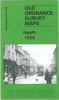
Neath 1935
Neath in 1935 in a fascinating series of reproductions of old Ordnance Survey plans in the Alan Godfrey Editions, ideal for anyone interested in the history of their neighbourhood or family. The map covers the centre of Neath, with some coverage northward across the River Neath. Coverage stretches from Cimla Road and Arthur Street northward to St Cattwg`s church at Cadoxton and eastward to Fishpond Wood. Features include GWR main line with Town station, GWR Neath Branch with Canal Side station, Vale of Neath line with Low Level station, GWR Neath & Brecon line; Gnoll House, St Illtyd`s church, Neath Canal, Victoria Gardens, St Thomas church, Market, Cattle Market, St David`s church, Castle Nedd, Pen-y-dre, County School, Vale of Neath Brewery, Tennant Canal, engine shed,
Cadoxton-Juxta-Neath, Cadoxton Place, etc. On the reverse is a 1906 directory list of private residents, plus a 1929 timetable for the Court Sart branch.About the Alan Godfrey Editions of the 25” OS Series:Selected towns in Great Britain and Ireland are covered by maps showing the extent of urban development in the last decades of the 19th and early 20th century. The plans have been taken from the Ordnance Survey mapping and reprinted at about 15 inches to one mile (1:4, 340). On the reverse most maps have historical notes and many also include extracts from contemporary directories. Most maps cover about one mile (1.6kms) north/south, one and a half miles (2.4kms) across; adjoining sheets can be combined to provide wider coverage.FOR MORE INFORMATION AND A COMPLETE LIST OF ALL
AVAILABLE TITLES PLEASE CLICK ON THE SERIES LINK.

Product Description
Reviews/Comments
Add New
Vouchers
No voucher codes found.
Do you know a voucher code for this product or supplier? Add it to Insights for others to use.
Do you know a voucher code for this product or supplier? Add it to Insights for others to use.
 Denmark