More From Contributor
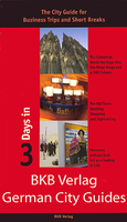
£9.99
Large street plan of Munich within its administrative boundaries, with an enlargement of the city centre, a plan of its airport, a diagram of the U & S-Bahn networks & a map of the outer suburbs all conveniently placed in a separate booklet. The main plan covers Munich at 1:22, 500, showing the city’s public transport network: tram & bus routes with stops & line numbers, plus U- & S-Bahn stations. Campsites & youth hostels are marked, as well as the usual range of facilities shown on street plans; public buildings, religious establishments, police, etc. Map legend which

Includes::
English is in a separate booklet attached to the map cover. The booklet also contains a very clear enlargement at 1:10, 000 of the town centre within the inner ring, indicating one way streets & public transport connection, a diagram of the U- & S-Bahn networks & an overview map of the city with its outer suburbs.

...
Archived Product
£4.99
Central Munich in a series of handy pocket street plans from Freytag & Berndt. Each map is laminated, so waterproof & tear-resistant, & highlights the publishers’ recommendations of five best choices in five categories: shopping, restaurants & cafes, culture, nightlife & sights. On one side is an indexed street plan annotated with colour-coded markers highlighting the publishers’ recommendations, all listed on the reverse of the map with brief notes in several languages. In larger cities the plans cover only the central districts. Also provided are a small road map of the city’s environs, if appropriate a diagram of the metro network, & a Fact Box with phone numbers for tourist offices, car hire & emergency services. Map legend & notes on the recommendations include English. To see other titles in this series please click on the series link. ...
Archived Product
£13.99
Large street plan of Munich within its administrative boundaries, with an enlargement of the city centre, a plan of its airport, a diagram of the U & S-Bahn networks & a map of the outer suburbs all conveniently placed in a separate booklet. The main plan covers Munich at 1:22, 500, showing the city’s public transport network: tram & bus routes with stops & line numbers, plus U- & S-Bahn stations. Campsites & youth hostels are marked, as well as the usual range of facilities shown on street plans; public buildings, religious establishments, police, etc. Map legend which

Includes::
English is in a separate booklet attached to the map cover. The booklet also contains a very clear enlargement at 1:10, 000 of the town centre within the inner ring, indicating one way streets & public transport connection, a diagram of the U- & S-Bahn networks & an overview map of the city with its outer suburbs.

...
Archived Product
£19.99
Large street plan of Munich within its administrative boundaries, with an enlargement of the city centre, a plan of its airport, a diagram of the U & S-Bahn networks & a map of the outer suburbs all conveniently placed in a separate booklet. The main plan covers Munich at 1:22, 500, showing the city’s public transport network: tram & bus routes with stops & line numbers, plus U- & S-Bahn stations. Campsites & youth hostels are marked, as well as the usual range of facilities shown on street plans; public buildings, religious establishments, police, etc. Map legend which

Includes::
English is in a separate booklet attached to the map cover. The booklet also contains a very clear enlargement at 1:10, 000 of the town centre within the inner ring, indicating one way streets & public transport connection, a diagram of the U- & S-Bahn networks & an overview map of the city with its outer suburbs.

...
Archived Product
£9.99
Street plan of the Munich conurbation in Falk’s Special Fold format, designed to show only a small section of the map at one time. The whole map can be opened but it will be cut in several places. Many find these street plans very user-friendly & easier to handle than conventional maps, others simply hate them!* About Falk street plans:* The plans indicate main landmarks & public buildings & show all the public transport facilities, one way streets & car parks. Plans of larger cities include a separate diagram of the public transport network & an enlargement of the town centre at a more detailed scale. The plans also show postal divisions & have an extensive street index which, where appropriate, shows individual postal codes for each street. * Map legend

Includes::
English.* Falk street plans are published in three different map formats, plus in a series of regional street atlases.* Falk Extra* plans are folded in a standard way, where the whole map can be opened to view the entire area it covers. In most plans on the reverse is a road map of the surrounding area. Latest editions have a UTM grid.* Falk Special Fold* plans, published only for larger cities, have a folding system designed to show only a small section of the map at one time. The whole map can be opened but it will be cut in several places. Many find these street plans very user-friendly & easier to handle than conventional maps, others simply hate them!* Falk City Plans*, published only for main cities, use the same mapping but cover a smaller area then the Extra plans & have a larger map of the city centre.

...
Archived Product
£9.99
Unusual, very attractive street plan of Munich offering a bird’s-eye view of the city with every building drawn to scale with full architectural detail, from street arcades to rooftops & inner courtyards. The plan, drawn in 2013, covers the city centre from the central railway station to the English Gardens & from the museums islands on the Isar to the Alte Pinakothek, & is annotated with small icons of various businesses which sponsored its production. On the reverse is a conventional street plan of the city with its outer suburbs. Street index, in a separate booklet, covers both plans &

Includes::
brief descriptions of the main monuments & places of interest, plus lists of local facilities & various shops & other businesses. All the text is in German only.

...
Archived Product
£7.99
Munich in the Pocket Guide series from Insight provides detailed commentary on a collection of itinerary based trips in a handy pocket format. Each guide has an historical & cultural introduction, profiling the growth of the region or city. There is also a large selection of localised & pedestrian friendly tour itineraries designed to take in the major sites, as well as a chapter on excursions to other destinations within easy reach. Further sections detail leisure activities including shopping, eating out, nightlife, festivals & local events with accompanying addresses & contact details where relevant. There is also practical guidance on transport, local services, language & accommodation. Each guide also has a large selection of colour photographs & a pull-out pocket map giving an overview of the region. ...
Archived Product
£4.99
Durable & waterproof, with a handy slipcase & an easy-fold format, Lonely Planet Munich City Map is your conveniently-sized passport to traveling with ease. Get more from your map & your trip with images & information about top city attractions, transport maps, itinerary suggestions, extensive street & site index, & practical travel tips & directory. With this easy-to-use, full colour navigation tool in your rear pocket, you can truly get to the heart of Munich. Covers Altstadt, Maxvorstadt, Neuhausen, Nymphenburg, Olympiapark, Westend, Ludwigsvorstadt, Glockenbachviertel, Lehel, Bogenhausen. ...
Archived Product
£5.99
Munich in the Everyman Map Guide series; comprising a range of practical guide books incorporating large scale maps to a number of international cities & regions. Including a unique binding method, each district, neighbourhood, area or region has an accompanying fold-out page with a large scale overview map which is fully indexed. Each Map Guide also has details of more than 100 shops, restaurants, bars, clubs, markets & other local attractions, in addition to more practical guidance, listed underneath & on the reverse of the fold-out map. All of the main attractions also have accompanying illustrations, & there are also transport maps & a street index to help visitors find their way around. ...
Archived Product
£5.99
Munich in the new Marco Polo Guide series designed to enable travellers to have fun & feel relaxed the moment they arrive to their destination. In a compact format & budget-priced, these guides feature full colour & high quality content with unique insider tips. The information is presented in a straightforward & engaging format with three main sections: an introduction to the location & including highlights & insider tips, a sightseeing & entertainment part, & a practical information chapter; all accompanied by atlas pages & a pull out map. The guides starts with a geographical & historical context, suggestions on what not to miss, great places for free, what to do if it rains, chill out, relax & unique experiences to make the visit even more memorable. The perfect route/day will show the best way to get to know a destination for those with limited time. The sightseeing chapters organise the area in sections & for each one show suggested routes, referenced to the atlas & pull-out map, best places & attractions with practical tips on how to avoid queues, get the best views, where to eat & drink, shopping, entertainment, where to stay & much more. The last section offers a few tours suggestions, travel with kids special pages, festivals & events calendar, travel tips, useful phrases & dos & don ...
Archived Product

Munich In 3 Days

BKB Verlag’s guide to Munich is specially designed for business trips and short trips, aiming to show you the best of the city in just 3 days. Pocket-sized and printed with full-colour photos, the guide is broken down into 4 sections, one for each day and a final chapter on ‘services’.Each day section has been arranged like a diary, so that the sights are described in the order of a potential itinerary, making you get the most out of what you see. A small map precedes each day, showing the recommended route to take for the sights within the chapter; the maps themselves are very basic, and would be better used as a general overview of the area.The final section is over 20 pages of listings and descriptions of cafes, restaurants, local culture, hotels, museums, nightlife,
shopping and more.
RIP - This product is no longer available on our network. It was last seen on 25.09.2019

This page now acts as a permanent archive for this product. Add more information using the comments box below to ensure it can still be found by future generations.

Use our search facility to see if it is available from an alternative contributor.
  • Availability: Out Of Stock
  • Supplier: Stanfords
  • SKU: 9783940914736
Availability: In Stock
£6.50

Product Description

BKB Verlag’s guide to Munich is specially designed for business trips & short trips, aiming to show you the best of the city in just 3 days. Pocket-sized & printed with full-colour photos, the guide is broken down into 4 sections, one for each day & a final chapter on ‘services’. Each day section has been arranged like a diary, so that the sights are described in the order of a potential itinerary, making you get the most out of what you see. A small map precedes each day, showing the recommended route to take for the sights within the chapter; the maps themselves are very basic, & would be better used as a general overview of the area. The final section is over 20 pages of listings & descriptions of cafes, restaurants, local culture, hotels, museums, nightlife, shopping & more.

Reviews/Comments

Add New

Intelligent Comparison

Oooops!
We couldn't find anything!
Perhaps this product's unique.... Or perhaps we are still looking for comparisons!
Click to bump this page and we'll hurry up.

Price History

Vouchers

No voucher codes found.
Do you know a voucher code for this product or supplier? Add it to Insights for others to use.

Facebook

Jargon Buster

Colour - The categorised spectrum of light visable to humans
Day - The time it takes a planet or other space objects to complete one rotation.
Small - something that takes up less space than normal.
Diary - A day to day book record of events and experiences.
Pocket - A bag shaped insert in clothing used to carry items

Supplier Information

Stanfords
Stanfords was established in 1853 and opened their iconic Covent Garden flagship store in 1901. They have become the top retailer of maps, travel books and accessories in the UK and arguably offer the largest selection of maps and travel books worldwide. Famous names such as Captain Robert Falcon Scott, Ranulph Fiennes and Michael Palin have purchased from Stanfords. They now have a shop in Bristol and both stores together with other venues operate a calendar of events including talks, book signings and exhibitions. As a specialist map retailer, the map selection is comprehensive and includes road maps, street maps and walking maps from worldwide destinations, as well as a selection of world atlases and wall maps. Books include travel guides and travel literature. Stanfords also stock globes, from miniatures made of blue marble to magnificent floor-standing globes. The website features a selection of interesting articles on travel topics.
Page Updated: 2023-11-12 20:15:36

Community Generated Product Tags

Oh No! The productWIKI community hasn't generated any tags for this product yet!
Menu