
 United Kingdom
 France
 Germany
 Netherlands
 Sweden
 USA
USA
 Italy
Italy
 Spain
Spain
More From Contributor


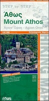
Mount Athos
Mount Athos at 1:60, 000 on a GPS compatible, contoured map from Orama Editions printed on light, waterproof and tear-resistant synthetic paper, with on the reverse descriptions of several hiking routes between the area’s famous monasteries.On one side is the whole Mount Athos peninsula with the Amouliani Island and coverage extending north-west beyond the town of Ierisos. Topography is shown by contours at 20m intervals, enhanced by relief shading. All place names are in both Greek and Latin alphabets. The map indicates roads in poor condition or passable only in 4WD vehicles, local paths, and ferry routes along the coast. The area’s famous monasteries are prominently highlighted. The map has a 1-km UTM grid plus latitude/longitude crosshairs at 2’ intervals, and is indexed.
On the reverse side is a simplified version of about half of the main map; contour lines have been reduced to 100m intervals and most places names have been removed, leaving just the main villages and the monasteries with the network of connecting roads, tracks and paths. Accompanying this map are detailed bilingual descriptions of 11 hiking routes.Map legend and route descriptions include English.
On the reverse side is a simplified version of about half of the main map; contour lines have been reduced to 100m intervals and most places names have been removed, leaving just the main villages and the monasteries with the network of connecting roads, tracks and paths. Accompanying this map are detailed bilingual descriptions of 11 hiking routes.Map legend and route descriptions include English.

Product Description
Reviews/Comments
Add New
Vouchers
No voucher codes found.
Do you know a voucher code for this product or supplier? Add it to Insights for others to use.
Do you know a voucher code for this product or supplier? Add it to Insights for others to use.
 Denmark