
 United Kingdom
 France
 Germany
 Netherlands
 Sweden
 USA
USA
 Italy
Italy
 Spain
Spain
More From Contributor

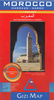

Morocco IGN
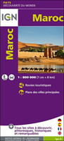
Morocco at 1:800, 000 on a road map from the Institut Geographique National with street plans of central Rabat, Marrakesh, Tangier, Fès and Meknès. Western Sahara is shown at 1:2, 500, 000. Cartography is from the renowned German map and guide publishers MairDumont. The map itself is the same as the version published in UK by Marco Polo Travel Publishing, but with self-cover and without the index booklet is less bulky than the Marco Polo edition.Topography is shown by relief shading with plenty of spot heights and names of mountain ranges. In the desert areas oasis and seasonal rivers are marked. Road network includes local roads and desert tracks, with intermediate driving distances marked on main and many local routes. Seasonal closures, steep gradients, etc, are indicated and
scenic routes are highlighted. The map also includes railways and shows local airports.Picturesque towns or villages as well as many natural curiosities are prominently highlighted. Symbols indicate numerous other places of interest. The map shows the country’s internal administrative boundaries with names of the provinces and gives all place names in the Latin alphabet only, with major cities also in the Arabic version (Casablanca/Ad-dar-Al-Bayda). Latitude and longitude lines are drawn at 2° intervals. This IGN version has no index but does include a distance table. Multilingual map legend includes English.
scenic routes are highlighted. The map also includes railways and shows local airports.Picturesque towns or villages as well as many natural curiosities are prominently highlighted. Symbols indicate numerous other places of interest. The map shows the country’s internal administrative boundaries with names of the provinces and gives all place names in the Latin alphabet only, with major cities also in the Arabic version (Casablanca/Ad-dar-Al-Bayda). Latitude and longitude lines are drawn at 2° intervals. This IGN version has no index but does include a distance table. Multilingual map legend includes English.

Product Description
Reviews/Comments
Add New
Vouchers
No voucher codes found.
Do you know a voucher code for this product or supplier? Add it to Insights for others to use.
Do you know a voucher code for this product or supplier? Add it to Insights for others to use.
 Denmark