More From Contributor

£11.99
World traveler Laura Martone spends summers with her family on Michigan's Big Bear Lake. In Moon Michigan she shares her favorite Michigan experiences, from indulging at the National Cherry Festival in Traverse City to exploring Detroit's rhythmic roots & auto museums. Martone provides itineraries such as trekking through the Upper Peninsula, touring lighthouses on the Great Lake shoreline, & splurging on a luxury B&B on the popular Mackinac Isl&. Moon Michigan is packed with information on dining, transportation, & accommodations. Complete with details on where to ice fish, taste-test local fudge & go golfing in the Lower Peninsula, Moon Michigan gives travelers the tools they need to create a more personal & memorable experience. ...
Archived Product
£19.95
Michigan Recreational Atlas & Gazetteer at 1:150, 000 approx. in a series of large format paperback state atlases from De Lorme, with detailed, contoured, GPS compatible topographic mapping plus extensive recreational information, with lists of sites & facilities, etc. Each title covers one state & presents it on impressively detailed mapping at scales much more detailed than used on most state road maps. Particularly popular areas are often also presented on enlargements. The maps are contoured, show variation of terrain (deserts, glaciers, wetlands, woodlands, etc) & have latitude & longitude and/or UTM grid lines for GPS use. Various types of protected areas are distinguished by the colouring of their boundaries, e.g. national or state parks, forests, etc. Also marked are Indian Reservations & restricted entry military zones. Road network is shown in much more detail than on other state mapping, with local roads, unsurfaced back roads & tracks, forest trails, etc. Where appropriate, old historical routes are marked. Railway lines & local airports or landing strips are included & the maps also indicate administrative boundaries. Symbols highlight various recreational areas & facilities such as campgrounds, unique natural features, etc. Each title contains extensive lists of outdoor adventure sites (grouped into activities such as hiking, biking, paddling, fishing, skiing, etc.), diverse family outing sites, campgrounds, & tables showing what facilities can be found in the state ...
Archived Product
£22.99
Michigan Recreational Atlas & Gazetteer at 1:150, 000 approx. in a series of large format paperback state atlases from De Lorme, with detailed, contoured, GPS compatible topographic mapping plus extensive recreational information, with lists of sites & facilities, etc. Recreational information in this title

Includes::
lists of forests/wilderness areas, beaches, wildlife sites, gardens, wineries, excursions/scenic drives, art museums/science centres, historic sites/museums, waterfalls, unique natural features, inland fishing, Great Lakes fishing piers, hunting areas, canoe trips, cycling routes, downhill ski slopes, sport facilities, hiking trails, golf courses. Tables are also provided listing, where appropriate with facilities, parks & campgrounds. Each title in this De Lorme series covers one state & presents it at a scale much more detailed than used on most state road maps. Particularly popular areas are often also presented on enlargements. The maps are contoured, show variation of terrain (deserts, glaciers, wetlands, woodlands, etc) & have latitude & longitude and/or UTM grid lines for GPS use. Various types of protected areas are distinguished by the colouring of their boundaries, e.g. national or state parks, forests, etc. Also marked are Indian Reservations & restricted entry military zones. Road network is shown in much more detail than on other state mapping, with local roads, unsurfaced back roads & tracks, forest trails, etc. Where appropriate, old historical routes are marked. Railway lines & local airports or landing strips are included & the maps also indicate administrative boundaries. Symbols highlight various recreational areas & facilities such as campgrounds, unique natural features, etc. Each title contains extensive lists of outdoor adventure sites (grouped into activities such as hiking, biking, paddling, fishing, skiing, etc.), diverse family outing sites, campgrounds, & tables showing what facilities can be found in the state’s recreational areas. Each atlas also has an index of localities. To see the list of titles in this series please click on the series link.

...
Archived Product
£30.00
Detailed physical wall map of Michigan State at a scale of 1:700, 000. The cartography shows relief through a stunning, highly ...
Archived Product
£4.99
Michigan's Traverse Bays & Mackinac Island in the Moon Spotlight guide series; covering a range of specific local cities, districts, areas & regions in North, Central & South America & targeted at those seeking to travel to a specific area within a country. Each of the guides has been extracted in full from the relevant country Moon Handbook & individual titles focus on a particular city, region or notable area of the destination. Many of the guides in the series are unique in their coverage, although are limited in putting the destination into its wider geographical context that a more comprehensive guide would provide. Stylistically, Moon ...
Archived Product
£5.99
Moon Spotlight Michigan`s Traverse Bays & Mackinac Island is an 80-page compact guide covering the best of northern Michigan, including Traverse City, the Leelanau Peninsula, Petoskey, & Cheboygan. Author Laura Martone offers her firsthand advice on must-see attractions &

Includes::
maps with sightseeing highlights so you can make the most of your time. This lightweight guide is packed with recommendations on sights, entertainment, shopping, recreation, accommodations, food, & transportation, making navigating this popular vacation area uncomplicated & enjoyable. This Spotlight guidebook is excerpted from Moon Michigan.

...
Archived Product
£11.99
Born-&-raised Michigander Paul Vachon provides an insider`s view of the Upper Peninsula, from the delicious meat-filled pasties the area is famous for to the tremendous natural beauty on display there. To ensure that every traveler finds the trip suited to their individual needs, Vachon also offers carefully designed itineraries such as Best of Michigan`s Upper Peninsula, History Comes to Light, & Following the Lake Superior Trail. Complete with details on enjoying the tranquillity of Tahquamenon Falls, boating at Indian Lake State Park, & exploring Mackinac Isl&, Moon Michigan`s Upper Peninsula gives travellers the tools they need to create a more personal & memorable experience. ...
Archived Product
£10.50
One of the titles in a series of road maps of the administrative states of Mexico, highlighting places of interest. The maps show four different grades of roads, with intermediate driving distances on main routes, railways, local airports, ferry connections & administrative boundaries. Topographic information is limited to names of main mountain ranges, spot heights for main peaks, rivers & lakes. The maps have no geographical coordinates. Map legend is in Spanish only. On the reverse each title has a black & white version of the same map, highlighting places of interest with brief notes in Spanish only. ...
Archived Product
£12.99
One of the titles in a series of road maps of the administrative states of Mexico, highlighting places of interest. The maps show four different grades of roads, with intermediate driving distances on main routes, railways, local airports, ferry connections & administrative boundaries. Topographic information is limited to names of main mountain ranges, spot heights for main peaks, rivers & lakes. The maps have no geographical coordinates. Map legend is in Spanish only. On the reverse each title has a black & white version of the same map, highlighting places of interest with brief notes in Spanish only. ...
Archived Product

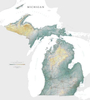
Michigan Upper Peninsula

Michigan’s Upper Peninsula in a series of indexed street plans of US cities from UniversalMAP. The main plan presents the region from the border with Wisconsin to the border with Ontario with numerous insets showing the more densely populated areas in greater detail. Coverage includes Baraga, Escanaba, Hancock, Houghton, Iron Mountain, Ironwood, L’Anse, Manistique, Marinette, Menominee, Sault Saint Marie and St. Ignace. Also included are a map of Isle Royale and a plan of the Northern Michigan University campus. In addition to the street index the map also includes a separate index of places of interest including airports, campgrounds, recreational facilities, etc.Street plans from UniversalMAP are indexed and show each city’s administrative divisions, zip code areas
and various facilities and services.
RIP - This product is no longer available on our network. It was last seen on 25.09.2019

This page now acts as a permanent archive for this product. Add more information using the comments box below to ensure it can still be found by future generations.

Use our search facility to see if it is available from an alternative contributor.
  • External links may include paid for promotion
  • Availability: Out Of Stock
  • Supplier: Stanfords
  • SKU: 9780762585571
Availability: In Stock
£8.99

Product Description

Michigan’s Upper Peninsula in a series of indexed street plans of US cities from Universal MAP. The main plan presents the region from the border with Wisconsin to the border with Ontario with numerous insets showing the more densely populated areas in greater detail. Coverage

Includes::
Baraga, Escanaba, Hancock, Houghton, Iron Mountain, Ironwood, L’ Anse, Manistique, Marinette, Menominee, Sault Saint Marie & St. Ignace. Also included are a map of Isle Royale & a plan of the Northern Michigan University campus. In addition to the street index the map also

Includes::
a separate index of places of interest including airports, campgrounds, recreational facilities, etc. Street plans from Universal MAP are indexed & show each city’s administrative divisions, zip code areas & various facilities & services.

Reviews/Comments

Add New

Intelligent Comparison

Oooops!
We couldn't find anything!
Perhaps this product's unique.... Or perhaps we are still looking for comparisons!
Click to bump this page and we'll hurry up.

Price History

Vouchers

No voucher codes found.
Do you know a voucher code for this product or supplier? Add it to Insights for others to use.

Facebook

Jargon Buster

ZIP - A device (Usualy Metal) used for temporarily attaching two pieces of fabric together
iron - An electrical deviced used for removing creases from fabrics
iron - A chemical element (FE). The most common element on earth
Zip - A Fastening which can open and close to get inside.

Supplier Information

Stanfords
Stanfords was established in 1853 and opened their iconic Covent Garden flagship store in 1901. They have become the top retailer of maps, travel books and accessories in the UK and arguably offer the largest selection of maps and travel books worldwide. Famous names such as Captain Robert Falcon Scott, Ranulph Fiennes and Michael Palin have purchased from Stanfords. They now have a shop in Bristol and both stores together with other venues operate a calendar of events including talks, book signings and exhibitions. As a specialist map retailer, the map selection is comprehensive and includes road maps, street maps and walking maps from worldwide destinations, as well as a selection of world atlases and wall maps. Books include travel guides and travel literature. Stanfords also stock globes, from miniatures made of blue marble to magnificent floor-standing globes. The website features a selection of interesting articles on travel topics.
Page Updated: 2023-11-12 20:15:36

Community Generated Product Tags

Oh No! The productWIKI community hasn't generated any tags for this product yet!
Menu