
 United Kingdom
 France
 Germany
 Netherlands
 Sweden
 USA
USA
 Italy
Italy
 Spain
Spain
More From Contributor


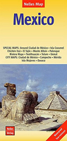
Mexico Nelles
Mexico at 1:2, 500, 000 from Nelles on a double-sided map with a convenient size for use when travelling. The map includes the neighboring countries to provide coverage of the Maya region, plus several enlargements, street plans, and plans of archaeological sites.The country is divided north/south, with a generous overlap between the two sides. Coverage extends south to include Belize, Guatemala, San Salvador and the western part of Honduras with Tegucigalpa. Relief shading with names of mountain ranges and peaks presents the topography. The map shows the road network, including selected local roads and tracks, with distances on main routes. Railway lines and local airports are also marked. National parks or protected areas and numerous places of interest are prominently
highlighted. Latitude and longitude are indicated by margin ticks at intervals of 1°. The map is not indexed. Map legend includes English.Several insets provide enlargements, street plans and site plans of the country’s most visited areas and archaeological remains:* Enlargements showing in greater detail: the environs of Mexico City including Toluca, Cuernavaca and Puebla, Riviera Maya from Cancún to Tulúm, and the islands of Cozumel and Mujeres.* Street plans, annotated with places of interest, selected accommodation, etc, showing city centres of: Mexico City, Oaxaca, Mérida and Campeche.*Plans of the archaeological sites at Teotihuacán, Monte Albán, El Tajín, Palenque, Uxmal, Chichén Itzá and Tulúm,
highlighted. Latitude and longitude are indicated by margin ticks at intervals of 1°. The map is not indexed. Map legend includes English.Several insets provide enlargements, street plans and site plans of the country’s most visited areas and archaeological remains:* Enlargements showing in greater detail: the environs of Mexico City including Toluca, Cuernavaca and Puebla, Riviera Maya from Cancún to Tulúm, and the islands of Cozumel and Mujeres.* Street plans, annotated with places of interest, selected accommodation, etc, showing city centres of: Mexico City, Oaxaca, Mérida and Campeche.*Plans of the archaeological sites at Teotihuacán, Monte Albán, El Tajín, Palenque, Uxmal, Chichén Itzá and Tulúm,

Product Description
Reviews/Comments
Add New
Vouchers
No voucher codes found.
Do you know a voucher code for this product or supplier? Add it to Insights for others to use.
Do you know a voucher code for this product or supplier? Add it to Insights for others to use.
 Denmark