More From Contributor
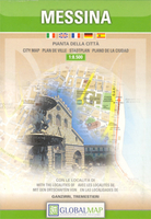
£110.00
Created for our mobile lifestyle, the Moleskine Messenger Bag is designed to be customized & organized with various add-ons. It can also hold the Moleskine Storage panel & Multipurpose cases. The modular double flap becomes a flexible space for carrying objects or closing the bag completely. in addition, the Messenger Bag fits any laptop with a screen size up to 15. External features include: water repellance, an elastic closure mechanism, a rigid base for standing the base vertically, an adjustable strap with a concealed sliding buckle, a modular double flap that forms an open pocket on 2 sides, snap fasteners to close the flap in 3 postions Internal feature include: an ivory velour lining, a lightly padded rear divider, the ability to fit any laptop with a screen up to 15, & a pocket with a zipper. It is also designed to hold the Moleskine Storage Panel & Multipurpose Cases
- please see individual products in the Moleskine ' Travelling' Collection for further details. The Messenger Bag is made from a matte black polyurethane on a woven support & also has a molded base made from soft-touch polyurethane.
...
Archived Product
£12.99
This is the first book in the thrilling, chilling new series from no. 1 bestselling author of Gone, Michael Grant. I remembered my name
- Mara. But, standing in that ghostly place, faced with the solemn young man in the black coat with silver skulls for buttons, I could recall nothing else about myself. & then the games began. Think you know the meaning of suspense? Think again... The Messenger sees the darkness in young hearts, & the damage it inflicts upon the world. If they go unpunished, he offers the wicked a game. Win, & they can go free. Lose, & they will live out their greatest fear. But what does any of this have to do with Mara? She is about to find out...
...
Archived Product
£7.99
The first book in the thrilling, chilling new series from no. 1 bestselling author of Gone, Michael Grant. I remembered my name
-
...
Archived Product
£8.99
Messengers sees Julian Sayarer return to work as a London bicycle courier, after six months cycling around the world. From saddle & kerbside, his stories of delivering flowers to politicians, & administration notices to banks toppled by the financial crisis, make for a social history of a less seen city, written from the perspective of someone stuck in one of London`s most insecure & poorly paid jobs. Underneath the deliveries, we meet London`s bicycle messengers, a family drawn from jaded graduates, jailbirds & recovering drug addicts. The riders all share their brushes with the law, struggles on the breadline & compete together in alleycat races, forming an unlikely but tender community upon the streets. With a bicycle the one constant that seems to make sense of everything else, Messengers is a two-wheeled portrait of everyday life in a modern city at the start of the twenty-first century. ...
Archived Product
£12.99
Fresh from a world of deserts, oceans & human kindness Julian Sayarer goes about adjusting back to the hard indifference of a city amongst ever-rising skyscrapers & the turning waters of the Thames. From a bicycle view of the streets, Messengers watches a merry-go-round of media sensation, consumerism & crony politics. Against this background Julian returns to the courier community, so telling the stories of both the jailbirds, drug addicts & alcoholics who can`t hold down any other job, & the fashionable graduates living the bohemian dream in a world of courier races & squat parties. From the saddle & ever-turning pedals, Messengers shows a hidden version of London`s underbelly & those living in the margins of the metropolis. ...
Archived Product
£29.99
Map No. 2230, Messina, in South Africa’s official topographic survey at 1:250, 000 from the country’s national survey organization, the Chief Directorate of Surveys & Mapping. The maps have altitude colouring & contours at 50m or 100m intervals, depending on the map edition, plus spot heights. Deserts, marshes, dry pans, perennial & seasonal water features, etc, as well as protected areas are shown. The maps present the country’s road & rail networks & include the usual information expected on topographic mapping at this scale, although in more rapidly developing areas road information may not necessarily be up to date. Also indicated are magisterial district & provincial boundaries. Latitude & longitude values are shown in the margins at 5` intervals together with South African grid co-ordinates. Typically, each sheet covers an area of one degree of latitude & two degrees of longitude. The projection used is Gauss Conformal. The legend is in English & Afrikaans. ...
Archived Product
£7.95
Messina Province in a series of handy size road maps from Litografia Artistica Cartografica (LAC) with more minor local roads & tracks than can be found on most regional maps. The series is gradually being changed to a new style of digitally derived cartography, so presentation of adjoining titles may vary. All the maps have hill shading to represent the general relief with spot heights for selected peaks, & show a few more local roads & rough tracks than the other road map series. Intermediate road distances are indicated. Regional, provincial & communal borders are marked, & railways, funiculars, airports, sea ferry links & campsites are shown. The legend is in Italian only. The new, digitally produced editions are indexed & have enhanced, more finely drawn cartography: the hill-shading is less bold, motorway service areas are marked, natural parks are highlighted & an expanded range of symbols indicates various landmarks & sites, e.g. antiquities, churches, etc. Two styles of the new cartography are produced, differing only in the colour of the predominant background shading: grey or yellow/green. Some of the new editions include geographical coordinates for the map corners. The index of localities is on the reverse. This title is still produced in the traditional cartographic style. ...
Archived Product
£12.99
Messina Province at 1:150, 000 in a series of handy size provincial road maps from Litografia Artistica Cartografica (LAC) with more minor local roads & country tracks than can be found on most regional maps from other publishers. This title is published with the traditional style LAC cartography. Coverage include Reggio di Calabria & Villa San Giovanni with ferry connections from the mainl&, & insets at 1:200, 000 cover the Aeolian (Lipari) Islands showing ferry connections between the islands & Milazzo, Messina & Reggio di Calabria LAC’s provincial series is gradually being changed to a new style of digitally derived cartography, so presentation of adjoining titles may vary. All the maps have hill shading to represent the general relief with spot heights for selected peaks, & show a few more local roads & rough tracks than the other road map series. Intermediate road distances are indicated. Regional, provincial & communal borders are marked, & railways, funiculars, airports, sea ferry links & campsites are shown. The legend is in Italian only. The new, digitally produced editions are indexed & have enhanced, more finely drawn cartography: the hill-shading is less bold, motorway service areas are marked, natural parks are highlighted & an expanded range of symbols indicates various landmarks & sites, e.g. antiquities, churches, etc. Two styles of the new cartography are produced, differing only in the colour of the predominant background shading: grey or yellow/green. Some of the new editions include geographical coordinates for the map corners. The index of localities is on the reverse. To see all the titles in this series please click on the series link. ...
Archived Product
£12.00
Inexplicably out of print since the late 1940s, Messing About in Boats is one of the most charming & evocative accounts of work & leisure afloat in the years either side of the Great War. John Muir describes with humanity & humour the perils of boat acquisition & ownership by the impecunious, & the somewhat mixed talents of the Paid H&. But his account is more than balanced by the interest & pleasure he took in working & sailing in English waters, from the North Sea to the Bristol Channel, in an age long before the marina, GPS & radio. Muir provides two valuable first-hand accounts of work afloat under steam & sail before the War, while he was on half-paid leave between assignments in the Royal Navy: In the North Sea `boxing` fleet of trawlers which remained on station for weeks on end, where he served in his medical capacity, & later in the Bristol Channel Pilot service, where he crewed on a cutter, delivering the pilot to incoming ships in all weathers. His unfavourable views of the qualities of the Bristol Channel Pilot Cutter as a yacht may surprise its aficionados today, but he relented sufficiently to own two of them, Maud & Freda, which feature in the book. ...
Archived Product

Messina

Messina on an indexed street plan at 1:8, 500 from Litografia Artistica Cartografica in their Globalmap imprint. 36 monuments including historic buildings and churches, cultural or educational institutions, and important municipal buildings or facilities are numbered and listed next to the plan. Car parks in and around the city’s historic centre are prominently marked. The city’s metro line and its stations, as well as car parks in the centre prominently marked. Insets cover Tremestieri (1:15, 000) and Ganzirri (1:25, 000) showing principal traffic routes and naming main streets.Litografia Artistica Cartografica (LAC) are Italy’s leading publishers of street plans with an extensive range of titles. Where appropriate, the plans include an enlargement showing the historic centre in
greater detail. On each plan monuments including historic buildings and churches, archaeological sites, cultural or educational institutions, and important municipal buildings or facilities are numbered and listed next to the plan. Unless indicated to the contrary in the individual description, one way streets are not marked. Street index is on the reverse.
RIP - This product is no longer available on our network. It was last seen on 25.09.2019

This page now acts as a permanent archive for this product. Add more information using the comments box below to ensure it can still be found by future generations.

Use our search facility to see if it is available from an alternative contributor.
  • External links may include paid for promotion
  • Availability: Out Of Stock
  • Supplier: Stanfords
  • SKU: 9788879143738
Availability: In Stock
£9.99

Product Description

Messina on an indexed street plan at 1:8, 500 from Litografia Artistica Cartografica in their Globalmap imprint. 36 monuments including historic buildings & churches, cultural or educational institutions, & important municipal buildings or facilities are numbered & listed next to the plan. Car parks in & around the city’s historic centre are prominently marked. The city’s metro line & its stations, as well as car parks in the centre prominently marked. Insets cover Tremestieri (1:15, 000) & Ganzirri (1:25, 000) showing principal traffic routes & naming main streets. Litografia Artistica Cartografica (LAC) are Italy’s leading publishers of street plans with an extensive range of titles. Where appropriate, the plans include an enlargement showing the historic centre in greater detail. On each plan monuments including historic buildings & churches, archaeological sites, cultural or educational institutions, & important municipal buildings or facilities are numbered & listed next to the plan. Unless indicated to the contrary in the individual description, one way streets are not marked. Street index is on the reverse.

Reviews/Comments

Add New

Price History

Vouchers

No voucher codes found.
Do you know a voucher code for this product or supplier? Add it to Insights for others to use.

Facebook

Jargon Buster

Car - A machine used for transport which runs on roads
Italy - a country in Europe.
Individual - A single separate item or person.

Supplier Information

Stanfords
Stanfords was established in 1853 and opened their iconic Covent Garden flagship store in 1901. They have become the top retailer of maps, travel books and accessories in the UK and arguably offer the largest selection of maps and travel books worldwide. Famous names such as Captain Robert Falcon Scott, Ranulph Fiennes and Michael Palin have purchased from Stanfords. They now have a shop in Bristol and both stores together with other venues operate a calendar of events including talks, book signings and exhibitions. As a specialist map retailer, the map selection is comprehensive and includes road maps, street maps and walking maps from worldwide destinations, as well as a selection of world atlases and wall maps. Books include travel guides and travel literature. Stanfords also stock globes, from miniatures made of blue marble to magnificent floor-standing globes. The website features a selection of interesting articles on travel topics.
Page Updated: 2023-11-12 20:15:36

Community Generated Product Tags

Oh No! The productWIKI community hasn't generated any tags for this product yet!
Menu