More From Contributor
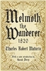
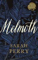
£12.99
Map No. 1190, Melchtal, in the topographic survey of Switzerland at 1:25, 000 from Bundesamt für Landestopographie (swisstopo), covering the whole country on 247 small format sheets, with special larger maps published for popular regions including some titles now available in hiking versions. Highly regarded for their superb use of graphic relief & hill shading, the maps give an almost 3-D picture of Switzerland`s mountainous terrain. Contours are at 10 m intervals, with 20m intervals in the mountainous areas. All the maps have a 1-km grid for Swiss national coordinates (datum CH 1903). * Small format sheets (Nos. 1011
- 1374)* Map legend in the language of the area covered by the map. Additional margin ticks show latitude & longitude in steps of 2`. The area covered by each map is 17 x 12 km (11 x 7 miles approx). * Special larger sheets (Nos. from 2501 onwards) – STANDARD editions:* No map legend is included but a separate leaflet can be provided instead. The area covered by each map is 25 x 17 km (15 x 11 miles approx).* Special larger sheets (Nos. from 2501 onwards) – HIKING editions:* An overprint highlights hiking, mountain & alpine paths, including regional & national long-distance trails. The maps also show bus routes with bus stops, plus inns in remote locations. The area covered by each map is 25 x 17 km (15 x 11 miles approx).
...
Archived Product
£11.50
Topographic survey of France at 1:25, 000 in IGN`s excellent TOP25 / Série Bleue series. All the maps are GPS compatible, with a 1km UTM grid plus latitude & longitude lines at 5’ intervals. Contours are at 5m intervals except for mountainous areas where the maps have contours at 10m intervals, vividly enhanced by hill shading & graphics for rocky terrain. Colouring with graphics indicates different types of vegetation or land use (deciduous or coniferous forests, moors, orchards, vineyards, etc). PLEASE NOTE: coverage of France at this scale is currently being revised – the format & the presentation of each title are indicated by the letters at the end of its Sheet Reference number (e.g. 0416ET, 3531ETR, 1923SB, etc.)MAPS WITH FULL TOURIST OVERPRINT & AN ENGLISH MAP LEGEND: all TOP25 maps & the SB editions of Série Bleue have an overprint highlighting waymarked walking trails including long-distance GR routes &, where appropriate, ski routes. Symbols indicate campsites, gîtes d’etape, refuges, equestrian centres & other recreational facilities or sites, tourist information centres, cultural heritage, etc. Towns & locations of particular interest are highlighted.- ET or OT = single-sided TOP25 map covering approx. 29x 21 km / 18x 13 miles.- ETR or OTR = waterproof & tear resistant TOP25 map covering the same area as the corresponding ET or OT number, but double-sided, printed on a smaller size sheet with a good overlap between the sides.- SB = Série Bleue map with full tourist overprint; these maps, first introduced in summer 2014, each cover approx. 29x 24km / 18x 15 miles.SÉRIE BLEUE maps with numbers ending in E (Est) or O (Ouest): most editions now indicate the GR routes, but do not show any other tourist information. Map legend is in French only. Each map covers approx. 14x 20km / 9x 12 miles. ...
Archived Product
£6.99
In this laugh-out-loud, riotous new book from picture book master Charlotte Voake, follow Melissa, her friends, & all their rather unsuitable pets! There are certain animals that make suitable pets, like a cat, a dog or a guinea pig. Then there are other animals that definitely make unsuitable pets, like an octopus, a warthog or an elephant. They are much too large, too messy &, well, just a tad free-spirited. They also have a tendency to break things.. .like floors, ceilings & tables. But can you guess what makes the most unsuitable pet ever? Here`s a clue.. .he has a long, scaly green tail & very sharp teeth. ...
Archived Product
£12.99
Topographic survey of France at 1:25, 000 in IGN`s excellent TOP25 / Série Bleue series. All the maps are GPS compatible, with a 1km UTM grid plus latitude & longitude lines at 5’ intervals. Contours are at 5m intervals except for mountainous areas where the maps have contours at 10m intervals, vividly enhanced by hill shading & graphics for rocky terrain. Colouring with graphics indicates different types of vegetation or land use (deciduous or coniferous forests, moors, orchards, vineyards, etc). PLEASE NOTE: coverage of France at this scale is currently being revised – the format & the presentation of each title are indicated by the letters at the end of its Sheet Reference number (e.g. 0416ET, 3531ETR, 1923SB, etc.)MAPS WITH FULL TOURIST OVERPRINT & AN ENGLISH MAP LEGEND: all TOP25 maps & the SB editions of Série Bleue have an overprint highlighting waymarked walking trails including long-distance GR routes &, where appropriate, ski routes. Symbols indicate campsites, gîtes d’etape, refuges, equestrian centres & other recreational facilities or sites, tourist information centres, cultural heritage, etc. Towns & locations of particular interest are highlighted.- ET or OT = single-sided TOP25 map covering approx. 29x 21 km / 18x 13 miles.- ETR or OTR = waterproof & tear resistant TOP25 map covering the same area as the corresponding ET or OT number, but double-sided, printed on a smaller size sheet with a good overlap between the sides.- SB = Série Bleue map with full tourist overprint; these maps, first introduced in summer 2014, each cover approx. 29x 24km / 18x 15 miles.SÉRIE BLEUE maps with numbers ending in E (Est) or O (Ouest): most editions now indicate the GR routes, but do not show any other tourist information. Map legend is in French only. Each map covers approx. 14x 20km / 9x 12 miles. ...
Archived Product
£16.99
Topographic survey of Sweden at 1:50, 000, the Terrängkartan, from the Lantmäteriet, covering most of the country in 244 double-sided maps. Please note: the mountainous regions of central & northern Sweden are not covered by this series but presented in a separate “ Fjällkartan
- Mountain Map” series also listed on our website. Each 1:50, 000 topographic survey map covers an area of 37.5 x 40km. The maps have contours at 5 metre intervals, plus relief shading & graphics for rocky outcrops & boulders. Further graphics and/or colouring show different types of land use or vegetation (forests, arable l&, orchards, marshes, peat bogs, etc). An unusual feature of this survey is the colouring indicating buildings below or above two storeys high & “leisure/holiday homes”. The maps indicate privately maintained roads & include all other information expected of topographic survey at this scale. The maps have a 1-km UTM grid, plus latitude & longitude lines 5’ intervals. Map legend

Includes::
English. For coverage of the country’s most visited hiking areas in central & northern Sweden please see Lantmäteriet’s Mountain Map series, listed separately on our website.


...
Archived Product
£8.99
When a young Dublin student goes to pay his last respects to his dying uncle, he never imagines that he might chance upon a terrifying family secret. Who is the sinister old man in the portrait & why is his uncle so anxious for him to burn it? Why is the Spanish man who saves him from drowning so frightened when he hears the name Melmoth? As he digs deeper into the mystery, an intricate & blood-chilling story begins to unfold. For the past two hundred years, the accursed Melmoth has been searching desperately for an escape from the infernal bargain he once made. Melmoth has traversed the globe leaving destruction & misery in his wake, from Inquisition-era Spain to a remote island in the Indian Ocean
- & there have been recent sightings of him in County Wicklow, where our narrator is still piecing the story together. This Victorian classic has captured the imaginations of readers since 1820 & inspired numerous other gothic masterpieces, including Oscar Wilde`s The Picture of Dorian Gray & Sarah Perry`s novel Melmoth.
...
Archived Product
£10.99
”1871. Cattle-dealer Solomon Meijer has made a reputation for himself as one of the few honest Jews in Endingen, a rare Swiss town in which Jews are allowed to reside. He leads a largely untroubled life, rewarded by his work & comforted at home by his wife & two daughters. But all of this is set to end when he answers a knock at the door in the middle of the night. On the doorstep stands his young distant cousin, Janki, half-dead & begging for refuge. The pitiful figure is invited in & given a coveted place in the bosom of the family, but when Janki recovers & regains his ambition & his fine-looks, he will change the Meijer family`s lives for generations to come... In the tradition of the great family romances of the nineteenth century, Melnitz is the saga of the Swiss-Jewish Meijer family, spanning five generations from the Franco-Prussian War to World War II. It is a novel of fate, fortune & great falls; a homage to the sunken world of yiddish culture & a celebration of the enduring spirit of biting Jewish humour.” ...
Archived Product
£15.99
This chocolate lollypop kit guaranties hours of yummy fun for the whole family: perfect for a kids party, a rainy day activity or just general fun at home with the family. Follow simple the instructions inside to make your own chocolate lollies. Adult supervision required. Suitable for children aged 5+. The box
Includes:: a chef's hat, milk chocolate buttons, animal moulds, sticks & full instructions.
...
Archived Product
£15.99
Create a grand day out in your very own kitchen with this melt & make chocolate London kit. Use the most delicious Belgian chocolate to build a Big Ben, a London taxi & a bus. Very simple to do with all you need in the box & perfect for a kids party, a rainy day activity or just general fun at home with the family. Adult supervision required. Suitable for children aged 6 +. The Make Your Own Chocolate London Kit
Includes:: a Chef's hat, milk Chocolate buttons for melting, a mould for Big Ben, London bus & taxi & full instructions.
...
Archived Product
£17.99
The 1:50 000 topographic map gives a more general picture of the ground features than a basic map. It shows settlements, houses, roads, cultivated areas, waterways, cutting areas, mires, rock exposures, & relief. One map sheet covers an area of 30 x 40 km & one centimetre corresponds to 500 metres on the ground. The 1:50, 000 topographic map is also an ideal complement to nautical charts as it provides useful information about the land areas adjacent to waterways. For example, all Finnish sea areas are covered by 1:50 000 topographic map sheets. ...
Archived Product

Melmoth

FROM THE 1 BESTSELLING AUTHOR OF THE ESSEX SERPENT`A beautiful, devastating, brilliant book` Marian Keyes`Astonishingly dark, rich storytelling, exquisitely balanced between gothic shocks and emotional truth` Francis Spufford`Mythic, ominous and sensitively human, Melmoth is haunting in all the best ways` Frances HardingeTwenty years ago Helen Franklin did something she cannot forgive herself for, and she has spent every day since barricading herself against its memory. But her sheltered life is about to change.A strange manuscript has come into her possession. It is filled with testimonies from the darkest chapters of human history, which all record sightings of a tall, silent woman in black, with unblinking eyes and bleeding feet: Melmoth, the loneliest being in the world.
Condemned to walk the Earth forever, she tries to beguile the guilty and lure them away for a lifetime wandering alongside her.Everyone that Melmoth seeks out must make a choice: to live with what they`ve done, or be led into the darkness. Helen can`t stop reading, or shake the feeling that someone is watching her. As her past finally catches up with her, she too must choose which path to take.Exquisitely written, and gripping until the very last page, this is a masterpiece of moral complexity, asking us profound questions about mercy, redemption, and how to make the best of our conflicted world.
RIP - This product is no longer available on our network. It was last seen on 25.09.2019

This page now acts as a permanent archive for this product. Add more information using the comments box below to ensure it can still be found by future generations.

Use our search facility to see if it is available from an alternative contributor.
  • Availability: Out Of Stock
  • Supplier: Stanfords
  • SKU: 9781788160650
Availability: In Stock
£16.99

Product Description

FROM THE 1 BESTSELLING AUTHOR OF THE ESSEX SERPENT`A beautiful, devastating, brilliant book` Marian Keyes` Astonishingly dark, rich storytelling, exquisitely balanced between gothic shocks & emotional truth` Francis Spufford` Mythic, ominous & sensitively human, Melmoth is haunting in all the best ways` Frances Hardinge Twenty years ago Helen Franklin did something she cannot forgive herself for, & she has spent every day since barricading herself against its memory. But her sheltered life is about to change.A strange manuscript has come into her possession. It is filled with testimonies from the darkest chapters of human history, which all record sightings of a tall, silent woman in black, with unblinking eyes & bleeding feet: Melmoth, the loneliest being in the world. Condemned to walk the Earth forever, she tries to beguile the guilty & lure them away for a lifetime wandering alongside her. Everyone that Melmoth seeks out must make a choice: to live with what they`ve done, or be led into the darkness. Helen can`t stop reading, or shake the feeling that someone is watching her. As her past finally catches up with her, she too must choose which path to take. Exquisitely written, & gripping until the very last page, this is a masterpiece of moral complexity, asking us profound questions about mercy, redemption, & how to make the best of our conflicted world.

Reviews/Comments

Add New

Intelligent Comparison

Oooops!
We couldn't find anything!
Perhaps this product's unique.... Or perhaps we are still looking for comparisons!
Click to bump this page and we'll hurry up.

Price History

Vouchers

No voucher codes found.
Do you know a voucher code for this product or supplier? Add it to Insights for others to use.

Facebook

Jargon Buster

LED - Light Emitting Diode - a small light source
Black - A colour which does not emit any colour of the spectrum. Black absorbs all frequencies of the spectrum.
Dark - A colour which absorbs visable ligt so apears less light than objects that reflect light
Human - A highly developed and adapted mamal and deminant species on earth
History - Anything that happens in the past. An acedemic subject.
World - A physical grouping, commonly used to describe earth and everything associated with ti
Earth - A planet third from the sun. Similar size to Venus but rich in water and complex life.
Day - The time it takes a planet or other space objects to complete one rotation.
LED - Light Emitting Diode. A bulb that is very efficient at producing light. Often small.
Memory - A way to describe the way in which the brain can remember things.

Supplier Information

Stanfords
Stanfords was established in 1853 and opened their iconic Covent Garden flagship store in 1901. They have become the top retailer of maps, travel books and accessories in the UK and arguably offer the largest selection of maps and travel books worldwide. Famous names such as Captain Robert Falcon Scott, Ranulph Fiennes and Michael Palin have purchased from Stanfords. They now have a shop in Bristol and both stores together with other venues operate a calendar of events including talks, book signings and exhibitions. As a specialist map retailer, the map selection is comprehensive and includes road maps, street maps and walking maps from worldwide destinations, as well as a selection of world atlases and wall maps. Books include travel guides and travel literature. Stanfords also stock globes, from miniatures made of blue marble to magnificent floor-standing globes. The website features a selection of interesting articles on travel topics.
Page Updated: 2023-11-12 20:15:36

Community Generated Product Tags

Oh No! The productWIKI community hasn't generated any tags for this product yet!
Menu