More From Contributor

£8.99
Melbourne in the Step by Step series by Insight Guides focuses on providing tailor made walks & tours around the city. The guide features fourteen route recommendations that link up better known sights & take you off of the more beaten track; they are written by local experts who have personally selected places to eat & drink en-route & who offer insider tips on culture, shopping & nightlife. The guide has an array of colour photographs which help bring to life the background & descriptive information provided for destinations & attractions. An overview chapter opens the guide & reviews geography, customs & culture, history, food & drink, shopping, culture & entertainment. Next feature the selected itineraries for walks and/or tours, each of which have a good amount of accompanying information & come with a simple route plan. A user friendly alphabetical directory lists practical information to do with day to day basics & listings of h&-picked hotels & restaurants are provided to suit different budgets & tastes. The publisher ...
Archived Product
£10.99
The southern coastal region of Australia between Melbourne & Adelaide on a road map from Hema in their “ City to City” series linking Australia’s main centres of population; plus more detailed coverage of the Great Ocean Road & extensive additional tourist information. The main map at 1:900, 000 covers the coast between Melbourne & Adelaide, extending north to Victoria’s northern border along the Murray River. The map highlights the three main intercity connections: the princes Highway, the Western & Duke Highways, & the Calder & Strut Highways. Road network indicates freeways, sealed & unsealed roads & tracks, presenting them as appropriate with road numbers and/or names. Driving distances are marked on main & many local routes. Topography is indicated by names of hill ranges, plus graphics for swamps, dry lakes, salt flats, etc. National park & other protected areas are prominently highlighted. Symbols show campsites & caravan parks, rest areas with overnight accommodation, 24hour fuel supplies, information centres, other places of interest, etc. Latitude & longitude lines are drawn at 1º intervals. The map is accompanied by two panels showing main roads across the suburbs of Melbourne & Adelaide, plus distance tables for the three main highway connections. On the reverse the Great Ocean Road between Geelong & Victoria’s border with South Australia is presented in greater detail at 1:450, 000, with descriptions of 24 points of special interest highlighted on the map. The reverse side also carries descriptions of other places of interest in the whole region covered by the main map, a list of accredited information centres, plus a table of facilities on local national parks. To see the list of other titles in Hema’s City to City series please click on the series link. ...
Archived Product
£10.99
The south-eastern corner of Australia between Melbourne & Sydney on an indexed road map at 1:900, 000 from Hema, with enlargements showing suburban roads in these two cities, distance tables for the Hume & Princes Highways, plus on the reverse extensive tourist information including a table of facilities in the national parks. Coverage inland extends to the Lachan Valley in NSW in the north-western corner of the map & in the Sydney region

Includes::
the Great Western Highway across the Blue Mountain National Park, with Bathurst on the northern edge of the map. Road network indicates sealed or unsealed roads & 4WD tracks, with driving distances marked on main routes. The two main routes between the two cities, the Hume & the Prices Highway are highlighted, with a distance table for each placed one next to the map. Icons indicate various facilities including camping areas & caravan parks, different types of rest areas, a selection of 24hr fuel stations, visitor centres, etc. Topography is very effectively presented by relief shading plus spot heights & names of mountain ranges, etc, plus colouring indicating national or state parks & other protected areas where the map also shows numerous hiking trails. Latitude & longitude lines are drawn at 1º intervals. The map is indexed &

Includes::
two additional panels presenting in greater detail through roads across the suburbs or Melbourne & Sydney. On the reverse is a table showing what facilities can be found in over 90 national parks, contact details for Visitor Information Centres, plus extensive notes about the region’s best sights, many illustrated with colour photos. To see the list of titles in this series please click on the series link.


...
Archived Product
£6.99
Melbourne City Pocket Map from UBD Gregpry’s combining street plans of Melbourne’s CDB districts, indexed for streets & selected buildings/institutions, with on the reverse a road map of the city with its outer suburbs. On one side is a very detailed street plan of the city’s Central Business District, extending south to the Government House. The plan highlights main traffic arteries & shows one way streets. Numerous individual buildings are named & streets are annotated with selected house numbers for easier identification of addresses. Symbols highlight various facilities & places of interest. The plan has both a street index & a separate extensive “ Building Index” listing hotels/motels, major banks, car parks, shopping complexes/markets, theatres/cinemas & tourist information offices. On the reverse is a road map of the city & its suburbs at 1:120, 000 with an index of localities & main streets, plus of Melbourne’s suburban highlights. To see a list of other street plans & directories from UBD Gregory`s please click on the series link. ...
Archived Product
£6.95
Melbourne in the Wallpaper* City Guide series, published by Phaidon & encompassing a collection of pocket-size guides dedicated to the best design elements in major cities. Compiled by experts at the Wallpaper* magazine, the guides are widely recognized for appealing to design-conscious travellers & are aimed at those interested in art, design & architecture. Each guide identifies the best bars, restaurants, hotels, places to shop, leisure activities & excursions with a unique emphasis on the finest examples of unusual architecture & design. Each Wallpaper* City Guide has the same layout, with separate tabs allowing readers & travellers to access individual sections easily. The tabs consist of Landmarks, Hotels, 24 Hours, Urban Life, Architour, Shopping, Sports & Escapes. High quality colour photographs appear alongside brief descriptions of each hotel, bar or attraction, highlighting distinctive & unusual styles of architecture & design. Extra pages are provided at the back of each guide, allowing readers to record their own notes & sketches. ...
Archived Product
£12.99
Map No. 1190, Melchtal, in the topographic survey of Switzerland at 1:25, 000 from Bundesamt für Landestopographie (swisstopo), covering the whole country on 247 small format sheets, with special larger maps published for popular regions including some titles now available in hiking versions. Highly regarded for their superb use of graphic relief & hill shading, the maps give an almost 3-D picture of Switzerland`s mountainous terrain. Contours are at 10 m intervals, with 20m intervals in the mountainous areas. All the maps have a 1-km grid for Swiss national coordinates (datum CH 1903). * Small format sheets (Nos. 1011
- 1374)* Map legend in the language of the area covered by the map. Additional margin ticks show latitude & longitude in steps of 2`. The area covered by each map is 17 x 12 km (11 x 7 miles approx). * Special larger sheets (Nos. from 2501 onwards) – STANDARD editions:* No map legend is included but a separate leaflet can be provided instead. The area covered by each map is 25 x 17 km (15 x 11 miles approx).* Special larger sheets (Nos. from 2501 onwards) – HIKING editions:* An overprint highlights hiking, mountain & alpine paths, including regional & national long-distance trails. The maps also show bus routes with bus stops, plus inns in remote locations. The area covered by each map is 25 x 17 km (15 x 11 miles approx).
...
Archived Product
£11.50
Topographic survey of France at 1:25, 000 in IGN`s excellent TOP25 / Série Bleue series. All the maps are GPS compatible, with a 1km UTM grid plus latitude & longitude lines at 5’ intervals. Contours are at 5m intervals except for mountainous areas where the maps have contours at 10m intervals, vividly enhanced by hill shading & graphics for rocky terrain. Colouring with graphics indicates different types of vegetation or land use (deciduous or coniferous forests, moors, orchards, vineyards, etc). PLEASE NOTE: coverage of France at this scale is currently being revised – the format & the presentation of each title are indicated by the letters at the end of its Sheet Reference number (e.g. 0416ET, 3531ETR, 1923SB, etc.)MAPS WITH FULL TOURIST OVERPRINT & AN ENGLISH MAP LEGEND: all TOP25 maps & the SB editions of Série Bleue have an overprint highlighting waymarked walking trails including long-distance GR routes &, where appropriate, ski routes. Symbols indicate campsites, gîtes d’etape, refuges, equestrian centres & other recreational facilities or sites, tourist information centres, cultural heritage, etc. Towns & locations of particular interest are highlighted.- ET or OT = single-sided TOP25 map covering approx. 29x 21 km / 18x 13 miles.- ETR or OTR = waterproof & tear resistant TOP25 map covering the same area as the corresponding ET or OT number, but double-sided, printed on a smaller size sheet with a good overlap between the sides.- SB = Série Bleue map with full tourist overprint; these maps, first introduced in summer 2014, each cover approx. 29x 24km / 18x 15 miles.SÉRIE BLEUE maps with numbers ending in E (Est) or O (Ouest): most editions now indicate the GR routes, but do not show any other tourist information. Map legend is in French only. Each map covers approx. 14x 20km / 9x 12 miles. ...
Archived Product
£6.99
In this laugh-out-loud, riotous new book from picture book master Charlotte Voake, follow Melissa, her friends, & all their rather unsuitable pets! There are certain animals that make suitable pets, like a cat, a dog or a guinea pig. Then there are other animals that definitely make unsuitable pets, like an octopus, a warthog or an elephant. They are much too large, too messy &, well, just a tad free-spirited. They also have a tendency to break things.. .like floors, ceilings & tables. But can you guess what makes the most unsuitable pet ever? Here`s a clue.. .he has a long, scaly green tail & very sharp teeth. ...
Archived Product
£12.99
Topographic survey of France at 1:25, 000 in IGN`s excellent TOP25 / Série Bleue series. All the maps are GPS compatible, with a 1km UTM grid plus latitude & longitude lines at 5’ intervals. Contours are at 5m intervals except for mountainous areas where the maps have contours at 10m intervals, vividly enhanced by hill shading & graphics for rocky terrain. Colouring with graphics indicates different types of vegetation or land use (deciduous or coniferous forests, moors, orchards, vineyards, etc). PLEASE NOTE: coverage of France at this scale is currently being revised – the format & the presentation of each title are indicated by the letters at the end of its Sheet Reference number (e.g. 0416ET, 3531ETR, 1923SB, etc.)MAPS WITH FULL TOURIST OVERPRINT & AN ENGLISH MAP LEGEND: all TOP25 maps & the SB editions of Série Bleue have an overprint highlighting waymarked walking trails including long-distance GR routes &, where appropriate, ski routes. Symbols indicate campsites, gîtes d’etape, refuges, equestrian centres & other recreational facilities or sites, tourist information centres, cultural heritage, etc. Towns & locations of particular interest are highlighted.- ET or OT = single-sided TOP25 map covering approx. 29x 21 km / 18x 13 miles.- ETR or OTR = waterproof & tear resistant TOP25 map covering the same area as the corresponding ET or OT number, but double-sided, printed on a smaller size sheet with a good overlap between the sides.- SB = Série Bleue map with full tourist overprint; these maps, first introduced in summer 2014, each cover approx. 29x 24km / 18x 15 miles.SÉRIE BLEUE maps with numbers ending in E (Est) or O (Ouest): most editions now indicate the GR routes, but do not show any other tourist information. Map legend is in French only. Each map covers approx. 14x 20km / 9x 12 miles. ...
Archived Product
£16.99
Topographic survey of Sweden at 1:50, 000, the Terrängkartan, from the Lantmäteriet, covering most of the country in 244 double-sided maps. Please note: the mountainous regions of central & northern Sweden are not covered by this series but presented in a separate “ Fjällkartan
- Mountain Map” series also listed on our website. Each 1:50, 000 topographic survey map covers an area of 37.5 x 40km. The maps have contours at 5 metre intervals, plus relief shading & graphics for rocky outcrops & boulders. Further graphics and/or colouring show different types of land use or vegetation (forests, arable l&, orchards, marshes, peat bogs, etc). An unusual feature of this survey is the colouring indicating buildings below or above two storeys high & “leisure/holiday homes”. The maps indicate privately maintained roads & include all other information expected of topographic survey at this scale. The maps have a 1-km UTM grid, plus latitude & longitude lines 5’ intervals. Map legend

Includes::
English. For coverage of the country’s most visited hiking areas in central & northern Sweden please see Lantmäteriet’s Mountain Map series, listed separately on our website.


...
Archived Product

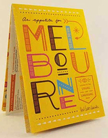
Melbourne: An Appetite For Melbourne Map/Guide

An Appetite for Melbourne in a series of City Map/Guides from Herb Lester Associates with 40 recommendations for how to get the best of the city, grouped into four sections: Easting & Drinking, Coffee, Shopping & Supplies, and Things to Do & See.Maps in this series are an eclectic selection of quirky titles designed to illuminate particular aspects of a city or a district. Each title lists publishers’ recommendations, ranging from the already famous attractions to little gems known only to the well informed locals, all with brief descriptions and, where appropriate, contact details.Accompanying maps are designed to highlight the locations of the recommended places rather than to provide an accurate presentation of the street network.To see other titles in this series please click
on the series link.
RIP - This product is no longer available on our network. It was last seen on 25.09.2019

This page now acts as a permanent archive for this product. Add more information using the comments box below to ensure it can still be found by future generations.

Use our search facility to see if it is available from an alternative contributor.
  • Availability: Out Of Stock
  • Supplier: Stanfords
  • SKU: 9781910023426
Availability: In Stock
£4.00

Product Description

An Appetite for Melbourne in a series of City Map/ Guides from Herb Lester Associates with 40 recommendations for how to get the best of the city, grouped into four sections: Easting & Drinking, Coffee, Shopping & Supplies, & Things to Do & See. Maps in this series are an eclectic selection of quirky titles designed to illuminate particular aspects of a city or a district. Each title lists publishers’ recommendations, ranging from the already famous attractions to little gems known only to the well informed locals, all with brief descriptions &, where appropriate, contact details. Accompanying maps are designed to highlight the locations of the recommended places rather than to provide an accurate presentation of the street network. To see other titles in this series please click on the series link.

Reviews/Comments

Add New

Intelligent Comparison

Oooops!
We couldn't find anything!
Perhaps this product's unique.... Or perhaps we are still looking for comparisons!
Click to bump this page and we'll hurry up.

Price History

Vouchers

No voucher codes found.
Do you know a voucher code for this product or supplier? Add it to Insights for others to use.

Facebook

Jargon Buster

Coffee - A popular brewed drink using roasted coffee beans
Network - A link and communication between things. Often computers or people.
Accurate - A measurement of precision when all elements are correct.

Supplier Information

Stanfords
Stanfords was established in 1853 and opened their iconic Covent Garden flagship store in 1901. They have become the top retailer of maps, travel books and accessories in the UK and arguably offer the largest selection of maps and travel books worldwide. Famous names such as Captain Robert Falcon Scott, Ranulph Fiennes and Michael Palin have purchased from Stanfords. They now have a shop in Bristol and both stores together with other venues operate a calendar of events including talks, book signings and exhibitions. As a specialist map retailer, the map selection is comprehensive and includes road maps, street maps and walking maps from worldwide destinations, as well as a selection of world atlases and wall maps. Books include travel guides and travel literature. Stanfords also stock globes, from miniatures made of blue marble to magnificent floor-standing globes. The website features a selection of interesting articles on travel topics.
Page Updated: 2023-11-12 20:15:36

Community Generated Product Tags

Oh No! The productWIKI community hasn't generated any tags for this product yet!
Menu