
 United Kingdom
 France
 Germany
 Netherlands
 Sweden
 USA
USA
 Italy
Italy
 Spain
Spain
More From Contributor


Tunisia F&B
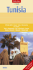
Tunisia at 1:700, 000 on a large indexed map from Freytag & Berndt with street plans of central Tunis and Sousse. The country’s topography is well presented by effective relief shading and numerous spot heights, enhanced by additional graphics for deserts, depressions, seasonal and perennial river and lakes, salt flats, wells, etc.Road network includes selected local roads and desert tracts, and shows driving distances on main routes. Railway lines are included and local airports are marked. The map also shows oil wells and pipelines and indicates internal administrative boundaries.National parks and other protected areas are prominently highlighted and symbols indicate various places of interest including archaeological sites, places of worship, etc. The map has a latitude and
longitude grid at intervals of 1°. The index of localities is on the reverse. Map legend includes English.Also provided is a street plan of central Tunis, plus a more basic plan of central Sousse naming just main streets.
longitude grid at intervals of 1°. The index of localities is on the reverse. Map legend includes English.Also provided is a street plan of central Tunis, plus a more basic plan of central Sousse naming just main streets.

Product Description
Reviews/Comments
Add New
Vouchers
No voucher codes found.
Do you know a voucher code for this product or supplier? Add it to Insights for others to use.
Do you know a voucher code for this product or supplier? Add it to Insights for others to use.
 Denmark