More From Contributor

£14.99
Waterproof & tear-resistant OS Active version of map No. 12 from the Ordnance Survey’s Landranger series at 1:50, 000, with contoured & GPS compatible topographic mapping plus tourist information.MOBILE DOWNLOADS: As well as the physical edition of the map, each Landranger title now

Includes::
a code for downloading after purchase its digital version onto your smartphone or tablet for viewing on the OS smartphone app.OS LANDRANGER SERIES: to see the list of all the titles in the OS Landranger series, both paper & waterproof versions, please click on the series link. Maps in the Landranger series provide plenty of recreational & tourist information, indicating the traditional public right of way paths (except in Scotland where different laws apply), including bridleways & byways restricted or open to motorized traffic. National Trails & selected other long-distance paths are marked, as well as on-road & traffic-free cycle routes with their National/ Regional Cycle Network numbers. National Trust/ National Trust for Scotland & Forestry Commission land is clearly marked, indicating open or restricted access. A range of symbols highlights camping & caravanning sites, youth hostels, tourist information offices & visitors’ centres, parking & picnicking places, World Heritage sites, sport & recreational facilities, etc. The maps provide detailed presentation of topography with contours at 10m intervals, numerous spot heights & additional colouring and/or graphics for different types of woodlands, orchards or parkl&, rock features including scree & cliffs, water features inland & along the sea shore with marshl&, dunes, s&, mud, shingle & the high water mark. All the standard information expected of survey mapping at this scale is included: finely graded road network, railway lines with stations, cuttings, embankments, etc; individual isolated buildings; archaeological & historical sites, etc. For GPS users the British National Grid is shown at 1km intervals, with latitude & longitude given by margin ticks at 1` & cross hairs on the map at 5`. Each map covers an area of 40 x 40km, (approx. 25 x 25 miles).

...
Archived Product
£8.99
Paper version of map No. 12 from the Ordnance Survey’s Landranger series at 1:50, 000, with contoured & GPS compatible topographic mapping plus tourist information.MOBILE DOWNLOADS: As well as the physical edition of the map, each Landranger title now

Includes::
a code for downloading after purchase its digital version onto your smartphone or tablet for viewing on the OS smartphone app.OS LANDRANGER SERIES: to see the list of all the titles in the OS Landranger series, both paper & waterproof versions, please click on the series link. Maps in the Landranger series provide plenty of recreational & tourist information, indicating the traditional public right of way paths (except in Scotland where different laws apply), including bridleways & byways restricted or open to motorized traffic. National Trails & selected other long-distance paths are marked, as well as on-road & traffic-free cycle routes with their National/ Regional Cycle Network numbers. National Trust/ National Trust for Scotland & Forestry Commission land is clearly marked, indicating open or restricted access. A range of symbols highlights camping & caravanning sites, youth hostels, tourist information offices & visitors’ centres, parking & picnicking places, World Heritage sites, sport & recreational facilities, etc. The maps provide detailed presentation of topography with contours at 10m intervals, numerous spot heights & additional colouring and/or graphics for different types of woodlands, orchards or parkl&, rock features including scree & cliffs, water features inland & along the sea shore with marshl&, dunes, s&, mud, shingle & the high water mark. All the standard information expected of survey mapping at this scale is included: finely graded road network, railway lines with stations, cuttings, embankments, etc; individual isolated buildings; archaeological & historical sites, etc. For GPS users the British National Grid is shown at 1km intervals, with latitude & longitude given by margin ticks at 1` & cross hairs on the map at 5`. Each map covers an area of 40 x 40km, (approx. 25 x 25 miles).

...
Archived Product
£2.50
Thurso street map from Nicolson Maps, Scotland’s premier cartographic publisher, including Brora, Castletown, Dunbeath, Golpsie, Halkirk, Helmsdale, Lybster, Wick, West Helmsdale. This title is part of the Street Guide Maps series, offering excellent & clear mapping of cities, towns & villages around the Great Britain. Please note, there is no actual written informative text, but the richness of symbology will provide visitors with ample information. The Street Guide Maps series from Nicolson Maps, Scotland’s premier cartographic publisher, offers excellent & clear mapping of cities, towns & villages around the UK. Most Nicolson’s maps are double-sided &, when applicable, cover additional locations on separate panels, each with a street index. The plans indicate, usually by different colours, primary routes plus A & B roads. Other roads, streets, tracks & paths are clearly shown as well as railway & bus stations. Symbols highlight location of various facilities, such as schools, libraries, places of worship, emergency services, petrol stations & car parks. Other places of interests like camping & caravan sites, historic buildings, museums, castles, information points etc. are also shown. ...
Archived Product
£18.99
Award-winning author Javier Marias examines a household living in the unhappy shadow of history, & explores the cruel, tender punishments we exact on those we love As a young man, Juan de Vere takes a job that will haunt him for the rest of his life. Eduardo Muriel is a famous film director
- urbane, discreet, irreproachable
- an irresistible idol to a young man. Muriel`s wife Beatriz is a soft, ripe woman who slips through her husband`s home like an unwanted ghost, finding solace in other beds. & on the periphery of all their lives stands Dr Jorge Van Vechten, a shadowy family friend implicated in unsavoury rumours that Muriel cannot bear to pursue himself
- rumours he asks Juan to investigate instead. But as Juan draws closer to the truth, he uncovers more questions, ones his employer has not asked & would rather not answer. Why does Muriel hate Beatriz? How did Beatriz meet Van Vechten? & what happened during the war? As Juan learns more about his employers, he begins to understand the conflicting pulls of desire, power & guilt that govern their lives
- & his own. Marias presents a study of the infinitely permeable boundaries between private & public selves, between observer & participant, between the deceptions we suffer from others & those we enact upon ourselves. ` No one else, anywhere, is writing quite like this` Daily Telegraph on The Infatuations


...
Archived Product
£8.99
Award-winning author Javier Marias weaves a darkly thrilling tale of love, betrayal & lives played out in the unhappy shadow of history As a young man, Juan de Vere takes a job that will haunt him for the rest of his life. Hi employer is Eduardo Muriel: a famous film director, sophisticated & discreet. Muriel`s wife Beatriz is a soft, ripe woman who slips through her husband`s home like an unwanted ghost, finding solace in other beds. & on the periphery of their lives stands Dr Jorge Van Vechten, a old family friend with a shadowy past. Juan enters eagerly into Muriel`s world of glamour & prestige, but as time passes he is troubled by many questions that seem to have no answer. Why does Muriel hate Beatriz? How did Beatriz meet Van Vechten? & what happened in the chaotic years after the war? As Juan learns more about his employers, his own innocence begins to fall away. Though he starts off as a mere observer, he is soon unable to stand on the side lines, compelled to interfere ever more dangerously in the dark interior of other people`s lives. Marias presents a study of the infinitely permeable boundaries between private & public selves, between observer & participant, between the deceptions we suffer from others & those we enact upon ourselves. ` No one else, anywhere, is writing quite like this` Daily Telegraph on The Infatuations ...
Archived Product
£14.99
Double-sided, waterproof & tear-resistant, contoured & GPS compatible map from Terra Quest, covering the whole of Kyrgyzstan at 1:1, 000, 000, with additional panels providing more detailed coverage for trekking at scales between 1:100, 000 & 1:125, 000 & covering the Karakol region, Ala-Archa, Inylchek area with Jengish Chokusu (Pobeda Peak) & Khan Tengri, plus the Lenin Peak (Peak Achiktash) border area. The map of Kyrgyzstan provides a very good presentation of the country’s geography through satellite-based relief & plenty of names of topographic features. National parks & other protected areas are highlighted. Road network shows distances on main routes. Symbols indicate various facilities & places of interest, including local airports, tourist information offices, etc. Latitude & longitude grid is at 10’ intervals. Multilingual map legend

Includes::
English. The map of Kyrgyzstan clearly shows which areas are presented in greater details on enlargements with contours at 50m intervals with numerous spot heights, relief shading, plus colouring for glaciers & forested areas. Trekking routes are marked, indicating more difficult sections & base camps. Symbols show locations with hotels & other tourist accommodation, restaurants & tourist information points. Latitude & longitude grid is at 1’ intervals. The map is laminated in a format similar to the old cloth-dissected maps so that sections of it can be easily folded back without damage.

...
Archived Product
£19.99
The easternmost part of Kyrgyzstan, between Lake Issyk-Kul & the Engilchek Glacier, on a contoured & GPS compatible, double-sided topographic map at 1:100, 000 from Goskartografiya in Bishkek, with most place names in the Latin alphabet & an English map legend. Coverage extends eastwards from Kyzyl-Suu, the easternmost part of Lake Issyk-Kul & Karakol to the Engilchek Glacier with the peaks of Jengish Chokusu (Pik Pobedy) & Khan Tengri. The map has contours at 40m intervals with numerous spot heights, plus colouring for forests, moraine & glaciers. Road network indicates paved, gravel & dirt roads. An overprint highlights trekking routes. Most place names, of both towns/settlements & of topographic features, have been transliterated into Latin alphabet. The map has a 2-km UTM grid. Map legend is in English.PLEASE NOTE: deliveries of titles published in Kyrgyzstan are infrequent
- no delivery time can be specified for any titles currently out of stock.
...
Archived Product
£6.50
Topographic coverage of the Canary Islands at 1:25, 000 published by the Instituto Geográfico Nacional – Centro Nacional de Información Geografica, the country’s civilian survey organization. The maps have contours at 10m intervals & colouring and/or graphics to show different types of vegetation or land use. Boundaries of national parks & other protected areas are marked. In addition to all the usual information shown on topographic mapping at this scale: detailed presentation of the road network with rural tracks & paths, etc, the maps also show campsites. The maps have a 1-km UTM grid, plus margin ticks for latitude & longitude at 1` intervals. The majority of the titles have been published since late 1990s. Map legend is in Spanish only.COVERAGE: each 25K map covers one quarter of the corresponding 1:50, 000 map, with the numbering system: I = NW quarter, II = NE quarter, III = SW quarter, & IV = SE quarter. To see other titles in this series please click on the series link. ...
Archived Product
£9.25
Indexed street plan of Tiberias (Teverya) from Israel’s national survey organization. Contours at 10m intervals, both above & below the sea level show the topography of the area. The plan covers the whole of the build-up area of the municipality, extending south to include the Swiss Forest & the Tiberias Hot Springs National Park. Symbols highlight various historical & archaeological sites, places of worship, shopping centres & other facilities, etc. The plan also shows the course of the Israel National Trail. All place names are in both Hebrew & Roman alphabets. Map legend &, on the reverse, & index of streets & institutions & facilities including hotels, is in Hebrew & English. ...
Archived Product
£11.99
One of the titles in a series of topographic maps covering much of north-west Africa, produced as part of the IMW* project in 1960’s. Each map covers an area spanning 6° in longitude & 4° in latitude. There is some variation in colouring & the depiction of terrain, but hill-shading, spot heights & contours are used to show the general relief. Additional graphics show features such as dunes, rock outcrops, cliffs, sand areas, escarpments, marshes, seasonal lakes & watercourses, & areas liable to flooding. Bathymetric contours are also included. Communications detail

Includes::
roads, major trails & railways, although there is some inconsistency in colouring & the extent of classification, e.g. not all maps distinguish seasonal roads. On most maps intermediate road distances are indicated on main routes. Symbols show airports, mosques, mines, oil & gas fields, lighthouses, ruins & significant isolated buildings. Administrative boundaries are marked & latitude & longitude lines are drawn at 1° intervals, with further margin ticks at 1’ intervals. The map legend is in French only on some sheets, & in English & French on others.* The International Map of the World was a project conceived in the early 20th century to compile a world map series at 1:1, 000, 000 through the efforts of participating nations. The value of the program has declined since 1970 & the IMW is no longer regarded as an active international series.

...
Archived Product

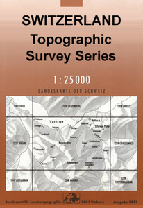
Thusis Swisstopo 1215

Map No. 1215, Thusis, in the topographic survey of Switzerland at 1:25, 000 from Bundesamt für Landestopographie (swisstopo), covering the whole country on 247 small format sheets, with special larger maps published for popular regions including some titles now available in hiking versions.Highly regarded for their superb use of graphic relief and hill shading, the maps give an almost 3-D picture of Switzerland`s mountainous terrain. Contours are at 10 m intervals, with 20m intervals in the mountainous areas. All the maps have a 1-km grid for Swiss national coordinates (datum CH 1903). *Small format sheets (Nos. 1011 - 1374)*Map legend in the language of the area covered by the map. Additional margin ticks show latitude and longitude in steps of 2`. The area covered by each map is
17 x 12 km (11 x 7 miles approx). *Special larger sheets (Nos. from 2501 onwards) – STANDARD editions:* No map legend is included but a separate leaflet can be provided instead. The area covered by each map is 25 x 17 km (15 x 11 miles approx).*Special larger sheets (Nos. from 2501 onwards) – HIKING editions:* An overprint highlights hiking, mountain and alpine paths, including regional and national long-distance trails. The maps also show bus routes with bus stops, plus inns in remote locations. The area covered by each map is 25 x 17 km (15 x 11 miles approx).
RIP - This product is no longer available on our network. It was last seen on 25.09.2019

This page now acts as a permanent archive for this product. Add more information using the comments box below to ensure it can still be found by future generations.

Use our search facility to see if it is available from an alternative contributor.
  • Availability: Out Of Stock
  • Supplier: Stanfords
  • SKU: 9783302012155
Availability: In Stock
£12.99

Product Description

Map No. 1215, Thusis, in the topographic survey of Switzerland at 1:25, 000 from Bundesamt für Landestopographie (swisstopo), covering the whole country on 247 small format sheets, with special larger maps published for popular regions including some titles now available in hiking versions. Highly regarded for their superb use of graphic relief & hill shading, the maps give an almost 3-D picture of Switzerland`s mountainous terrain. Contours are at 10 m intervals, with 20m intervals in the mountainous areas. All the maps have a 1-km grid for Swiss national coordinates (datum CH 1903). * Small format sheets (Nos. 1011
- 1374)* Map legend in the language of the area covered by the map. Additional margin ticks show latitude & longitude in steps of 2`. The area covered by each map is 17 x 12 km (11 x 7 miles approx). * Special larger sheets (Nos. from 2501 onwards) – STANDARD editions:* No map legend is included but a separate leaflet can be provided instead. The area covered by each map is 25 x 17 km (15 x 11 miles approx).* Special larger sheets (Nos. from 2501 onwards) – HIKING editions:* An overprint highlights hiking, mountain & alpine paths, including regional & national long-distance trails. The maps also show bus routes with bus stops, plus inns in remote locations. The area covered by each map is 25 x 17 km (15 x 11 miles approx).

Reviews/Comments

Add New

Intelligent Comparison

Oooops!
We couldn't find anything!
Perhaps this product's unique.... Or perhaps we are still looking for comparisons!
Click to bump this page and we'll hurry up.

Price History

Vouchers

No voucher codes found.
Do you know a voucher code for this product or supplier? Add it to Insights for others to use.

Facebook

Jargon Buster

Hiking - An outdoor activity envolving walking in nature
swiss - Short for Switzerland, one of the richest countries in the world
switzerland - A landlocked country in western Europe. One of the richest countries in the world
Language - the method of communication used in different areas. Humans and computers have many different languages.
Km - Kilometre. A unit of measurement equal to 1000 metres.
Small - something that takes up less space than normal.
Popular - Something that is admired and liked by many people.
Regional - An adjective to describe a set geographic area.
Language - The way humans communicate either written and spoken.

Supplier Information

Stanfords
Stanfords was established in 1853 and opened their iconic Covent Garden flagship store in 1901. They have become the top retailer of maps, travel books and accessories in the UK and arguably offer the largest selection of maps and travel books worldwide. Famous names such as Captain Robert Falcon Scott, Ranulph Fiennes and Michael Palin have purchased from Stanfords. They now have a shop in Bristol and both stores together with other venues operate a calendar of events including talks, book signings and exhibitions. As a specialist map retailer, the map selection is comprehensive and includes road maps, street maps and walking maps from worldwide destinations, as well as a selection of world atlases and wall maps. Books include travel guides and travel literature. Stanfords also stock globes, from miniatures made of blue marble to magnificent floor-standing globes. The website features a selection of interesting articles on travel topics.
Page Updated: 2023-11-12 20:15:36

Community Generated Product Tags

Oh No! The productWIKI community hasn't generated any tags for this product yet!
Menu