
 United Kingdom
 France
 Germany
 Netherlands
 Sweden
 USA
USA
 Italy
Italy
 Spain
Spain
More From Contributor


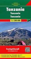
Tanzania F&B
Tanzania at 1:1, 300, 000 on an indexed map from Freytag & Berndt, prominently highlighting locations with various types of tourist accommodation, fuel supplies, places of interest, etc. The map presents the country’s road network including selected cart tracks, with driving distances marked on main routes and locations of petrol stations. Railway lines are included, domestic airports are marked, and the map also shows both coastal ferry connections and routes on Lake Victoria and Lake Tanganyika. Topography is presented by relief shading with spot heights. National park, games reserves and other protected areas are highlighted. Large icons prominently indicate various facilities and places of interest. Latitude and longitude lines are drawn at 1° intervals. The index is on the
reverse. Map legend includes English.
reverse. Map legend includes English.

Product Description
Reviews/Comments
Add New
Vouchers
No voucher codes found.
Do you know a voucher code for this product or supplier? Add it to Insights for others to use.
Do you know a voucher code for this product or supplier? Add it to Insights for others to use.
 Denmark