
 United Kingdom
 France
 Germany
 Netherlands
 Sweden
 USA
USA
 Italy
Italy
 Spain
Spain
More From Contributor

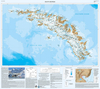

South Georgia Geological Map
South Georgia and its offshore islands in the South Atlantic presented by the British Antarctic Survey on a geological map at 1:250, 000 with geological units coloured in dark or light tints representing exposed (mountains or nunataks) and inferred geology (under ice, snow or vegetation). Please note: this is the 2011 version, full BSA ref. no. GEOMAP Series, Sheet4, Edition 1. A separate panel shows the Barff and Greene peninsulas in greater detail at 1:75, 000, and the map also includes four geological cross-sections and a list of references used in its compilation. PLEASE NOTE: to see other BAS maps of wider general interest please click on the series link. A separate series on our website presents BAS titles which are of interest mainly to scientific experts or academic staff:
larger scale topographic or geological/earth sciences maps of sections of the Antarctic and maps accompanied by detailed booklets/monographs.
larger scale topographic or geological/earth sciences maps of sections of the Antarctic and maps accompanied by detailed booklets/monographs.
Product Description
Reviews/Comments
Add New
Vouchers
No voucher codes found.
Do you know a voucher code for this product or supplier? Add it to Insights for others to use.
Do you know a voucher code for this product or supplier? Add it to Insights for others to use.
 Denmark