
 United Kingdom
 France
 Germany
 Netherlands
 Sweden
 USA
USA
 Italy
Italy
 Spain
Spain
More From Contributor


South Georgia Explorer
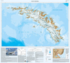
South Georgia at 1:250, 000 on a tourist map showing the island’s topography, with descriptions of places of interest, plus extensive text on its history and wildlife, biographies of main explorers, a time line from 1675 to 2001, etc.The main map presents the island at 1:250, 000, naming numerous peaks and glaciers, mountain ranges, bays and islets, etc. Historic sites, former whaling stations and scientific stations are marked with 22 places of special interest including wildlife breeding sites and geographical features prominently highlighted and accompanied by descriptions. Latitude and longitude lines are drawn at 20’ intervals. A small inset shows South Georgia with the South Shetland Islands, highlighting three more interesting sites.The reverse side provides an
introduction to the island, notes on its history and wildlife, a time line from the first sighting of South Georgia in 1675 to 2001, biographies of ten notable explorers connected with the island including Cook, Weddell and Shackleton. Also provided is a small map showing Shackleton’s route to and across South Georgia.
introduction to the island, notes on its history and wildlife, a time line from the first sighting of South Georgia in 1675 to 2001, biographies of ten notable explorers connected with the island including Cook, Weddell and Shackleton. Also provided is a small map showing Shackleton’s route to and across South Georgia.
Product Description
Reviews/Comments
Add New
Vouchers
No voucher codes found.
Do you know a voucher code for this product or supplier? Add it to Insights for others to use.
Do you know a voucher code for this product or supplier? Add it to Insights for others to use.
 Denmark