
 United Kingdom
 France
 Germany
 Netherlands
 Sweden
 USA
USA
 Italy
Italy
 Spain
Spain
More From Contributor


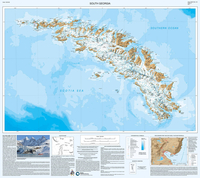
South Georgia BAS Wall Map
South Georgia and its offshore islands in the South Atlantic presented by the British Antarctic Survey on a double-sided map combining topographic mapping of the whole island at 1:200, 000 scale and detailed topographic mapping of the route of Shackleton’s crossing in May 1916 at 1:40, 000 scale.On one side is a map presenting the topography by contours at 100 m intervals with numerous trigonometric heights and spot heights. Colouring and graphics indicate ice-free terrain and moraine. Numerous glaciers, peaks, bays, etc, are named and the map shows locations of research stations and disused whaling stations.On the reverse side is a map covering the route which Sir Ernest Shackleton took during the first ever crossing of South Georgia from King Haakon Bay. This 1:40, 000 scale map
uses data created from VHR satellite imagery including contours at 50 m intervals and spot heights of the main peaks. This side also has 1:25, 000 scale insets of key areas along the crossing, and a cross section showing elevation along the route.Exploratory notes provide historical background on South Georgia and full technical specifications including data sources and references. Full BAS reference for this title is ”Sheets BAS (Misc) 12A and 12B”. This title is also available in a folded format.PLEASE NOTE: to see other BAS maps of wider general interest please click on the series link. A separate series on our website presents BAS titles which are of interest mainly to scientific experts or academic staff: larger scale topographic or geological/earth sciences maps of sections of
the Antarctic and maps accompanied by detailed booklets/monographs.

Product Description
Reviews/Comments
Add New
Vouchers
No voucher codes found.
Do you know a voucher code for this product or supplier? Add it to Insights for others to use.
Do you know a voucher code for this product or supplier? Add it to Insights for others to use.
 Denmark