More From Contributor

£15.99
The true Scot`s insider`s guide to the very best Scotland has to offer. Fully revised & updated in Pete Irvine`s own unique style.

Includes::
over 2000 recommendations for every type of adventure. Trusted for over 20 years, this fully comprehensive & independent guide to Scotland gives you only the very best recommendations, whatever your budget, from: * stunning scenery to historical highlights * Coastal walks to city strolls * Local cafes to regional restaurants * Wild camping to boutique hotels Peter Irvine is your personal guide to the very best of Scotl&, from the streets of Edinburgh to the Western Isles. He`s visited, rated & remarked on every one. The standard is high so you get the most out of the beloved country.

...
Archived Product
£12.99
Scotland in the Countries series from Time Out; comprehensive guides to a range of destinations, exploring the best places to stay, eat & explore. Based on their successful ‘ City Guides’ series, Time Out country guides have a similar format & cover an extensive range of activities, entertainment & sightseeing opportunities. Each guide is written by a team of experts who specialize in their locality, giving readers a detailed & thorough understanding of each region. An ‘ Editor’s Pick’ opening chapter summarizes some of the country’s ‘star destinations’ in categories including art & architecture, eating & drinking, historic sites, hotels, nightlife, outdoor activities, scenery, shopping, art & famous buildings. Each guide has a similar layout, allowing readers to plan their trip accordingly. Sections are thematically grouped & include categories such as rural idylls, cities, coast, small gems, mountains, rivers & wetlands & dramatic landscapes. Using Time Out’s extensive knowledge & experience of cities, this section is usually the most in-depth, including comprehensive listings for the best places to eat & drink, accommodation & local entertainment & nightlife. Individual features exploring specific facets of a local region or city are interlaced with the text & are compiled by knowledgeable local experts.A ‘ Need to Know’ chapter gives useful practical guidance on a range of matters including accommodation, age restrictions, airlines, customs, disabled travelers, driving, drugs, electricity, embassies & consulates, emergencies, health, language, money, opening hours, smoking, tax, telephones, time & seasons, tipping, trains, visas & weights & measures. There is also a calendar of local & national festivals & events that are held throughout the year, with website details where relevant. ...
Archived Product
£3.99
Scotland Touring Map from Collins presents the road network on a double sided sheet, with relevant associated motoring tourist material, at a scale of 1:316, 800 / 5 miles to 1. One side of the map covers northern Scotl&, whilst the reverse covers southern Scotl&. Enlargements of Inverness, Aberdeen, Glasgow, Dundee, Perth & Edinburgh town centres, as well as enlarged detail coverage of the Scottish Islands are provided. The map is indexed by both place name & by more than twenty categories of tourist information, including ancient monuments, castles, museums & botanical gardens, & showing the locations of over 2000 separate places of interest. Tourist information centres are shown according to whether they are open seasonally or year round. Motorway junctions with full & limited access, service areas (off road, full access & limited access) & distance markers are given. Car & passenger ferry routes are marked, as are canal routes, rail lines & stations, international & domestic airports. Spot heights are included & national parks/forests demarcated. Regional & county boundaries are illustrated. ...
Archived Product
£5.99
Scale: 1:316, 800 (5 miles to 1 inch). This popular touring map has a huge amount of detail with places of tourist interest plotted & named on the map. Fully updated for 2014. A clear, easy to follow road map with colour classified roads. The attractive hill shading shows the shape of the landscape & hundreds of places of tourist interest have been plotted & named on the map. There is a comprehensive index to both place names & places of tourist interest. This map
Includes:: the whole of Scotland on a double sided sheet at 5 miles to 1 inch. over 25 categories of tourist information shown on the map including youth hostels, picnic sites & ferries as well as the more obvious tourist sites such as castles, wildlife parks & museums. detailed town centre maps of Edinburgh, Glasgow, Aberdeen, Dundee, Inverness & Perth distances on the map along major routes. This best selling map contains everything for the holiday maker who wishes to explore this beautiful country.
...
Archived Product
£3.99
The Nicolson Scotlamd Tourist map is a 1:480, 000 scale road map suitable for touring. This map has clear, easy to read road mapping that shows all major & minor roads, tracks & paths. Also shown are railways & stations, tourist railway stations & disused railway lines, national cycle routes, & long distance footpaths. County boundaries are clearly marked, as are airports, hospitals, parking, hostels, visitor information centres, historic sites, peaks with height in meters, gardens, museums, heritage centres, viewpoints, nature reserves, picnic sites, camping grounds, caravan sites, golf courses, fishing spots & other places of interest. Natural features shown on the map include woodland areas, national/forest parklands, mud, shingle, beaches & dunes, rocks, & built up-areas. The map is fully indexed. ...
Archived Product
£19.99
Scotland in the National Geographic Traveler guide series, produced by America’s leading travel publishers, exploring a range of cities, regions & countries worldwide & using the expertise & tradition of National Geographic to provide a comprehensive survey of each destination. Each of the guides in the series draws upon National Geographic’s rich history of travel experience & is researched by authors familiar with the area. Whilst the content is influenced by an American editorial style, individual titles are still accessible to a non-American audience, with a combination of practical guidance & detailed information included in each guide. The series also relies upon the extensive image libraries of National Geographic to present a rich visual image of each destination. Individual National Geographic Traveler titles are organised uniformly, allowing readers to access information quickly & easily. Introductory sections provide information on Charting your Trip, with details of getting there & around & a History & Culture chapter profiling history, food & drink, land & landscape, flora & fauna & arts & literature. Chapter are arranged geographically by region, with notable cities & areas principally describing the main sites & attractions, with further information on directions, history & practicalities. There are also a number of individual features & insider tips throughout each guide covering subjects such as walking tours, local culture, driving tours, recommended local experiences & in-depth thematic short histories of the culture & histories of individual regions. A Travelwise section at the back of each guide provides essential practical information on when to go, what to take, further reading, getting there & around, local etiquette, media, holidays, money matters, religion, smoking, time differences, opening times, travellers with disabilities & accommodation. Restaurants & hotels are listed with brief descriptions & information on prices, location, contact details & facilities for the relevant regional chapters in the guide. ...
Archived Product
£16.99
The latest edition of National Geographic`s popular guidebook covers all the main cities, towns, & regions of Scotl&, helping travelers negotiate one of Europe`s more remote yet enduringly popular destinations. The book providesdetailed city walks in Edinburgh & Glasgow & drives into the highlands, complete with maps & reservation information. Also included are features on local subjects such as the whiskey-making traditions of Scotl&, as well as sidebars on a range of great activities to help you enjoy the rugged appeal of this truly beautiful l&. ...
Archived Product
£3.99
Scotland`s landscape is wildly diverse, ranging from towering mountains reflected in mirror-like lochs to ancient castles & bustling city streets. This wonderful book provides historic, geographic & arts-based text alongside captivating images of everywhere from the Borders in the south to Orkney in the north. The desirable, chunky format makes this an excellent travel companion for discovering both tourist destinations & lesser-known idyllic sites. ...
Archived Product
£9.99
A wall map of Scotland at 1:650, 000 from Global Mapping, 70 x 89cm (2ft 4” x 2ft 11”), showing the country’s network of main roads & railways on a base with relief shading & altitude colouring, with names of numerous peaks, valleys, coastal lochs, bays & sounds, etc. The map also shows county/unitary authorities names & borders, airports, ferry connections & various places of tourist interest: historical sites, castles & palaces, gardens, golf courses, etc. Latitude & longitude lines are marked at 1° intervals. ...
Archived Product
£13.00
Sample the whiskies, scratch off the map. An inspired fun gift! This Collect & Scratch print shows our selection of single malt Scotch whisky distilleries in Scotl&, each located by a nosing copita (tasting glass) icon. Scratch off the distilleries visited or whiskies sampled. Travel to find them, or just visit your local shop! Supplied in protective poster tube showcasing the product. Size A3 (297mm x 420mm). ...
Archived Product

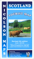
Scotland Tourist Map

Scotland’s road network on an indexed map at 1:480, 000 from Nicolson with symbols highlighting various places of interest, campsites, tourist information centres, etc. Coverage extends south-east to include Newcastle, Carlisle and the northern part of the Lake District. Current edition of this title was published in June 2015.Road network is presented on a base with colouring for woodlands and boundaries of national or forest parks, with plenty of names of mountain ranges, peaks and other topographic features. Narrow roads with passing places are indicated and driving distances are marked on main routes. The map also indicates selected national cycle routes and long-distance hiking trails. Symbols highlight various facilities and places of interest including campsites and caravan
parks, tourist information offices, historic buildings, golf courses, etc. The map has no geographical coordinates. The index is on the reverse.
RIP - This product is no longer available on our network. It was last seen on 25.09.2019

This page now acts as a permanent archive for this product. Add more information using the comments box below to ensure it can still be found by future generations.

Use our search facility to see if it is available from an alternative contributor.
  • Availability: Out Of Stock
  • Supplier: Stanfords
  • SKU: 9781860973901
Availability: In Stock
£4.99

Product Description

Scotland’s road network on an indexed map at 1:480, 000 from Nicolson with symbols highlighting various places of interest, campsites, tourist information centres, etc. Coverage extends south-east to include Newcastle, Carlisle & the northern part of the Lake District. Current edition of this title was published in June 2015. Road network is presented on a base with colouring for woodlands & boundaries of national or forest parks, with plenty of names of mountain ranges, peaks & other topographic features. Narrow roads with passing places are indicated & driving distances are marked on main routes. The map also indicates selected national cycle routes & long-distance hiking trails. Symbols highlight various facilities & places of interest including campsites & caravan parks, tourist information offices, historic buildings, golf courses, etc. The map has no geographical coordinates. The index is on the reverse.

Reviews/Comments

Add New

Intelligent Comparison

Oooops!
We couldn't find anything!
Perhaps this product's unique.... Or perhaps we are still looking for comparisons!
Click to bump this page and we'll hurry up.

Price History

Vouchers

No voucher codes found.
Do you know a voucher code for this product or supplier? Add it to Insights for others to use.

Facebook

Jargon Buster

Forest - A area with a high density of trees
Hiking - An outdoor activity envolving walking in nature
Network - A link and communication between things. Often computers or people.
Road - a manmade lane or a path that is used to speed up travel.
Golf - A sport played on a large outside grass course, the aim to hit a small ball with a club into small holes.

Supplier Information

Stanfords
Stanfords was established in 1853 and opened their iconic Covent Garden flagship store in 1901. They have become the top retailer of maps, travel books and accessories in the UK and arguably offer the largest selection of maps and travel books worldwide. Famous names such as Captain Robert Falcon Scott, Ranulph Fiennes and Michael Palin have purchased from Stanfords. They now have a shop in Bristol and both stores together with other venues operate a calendar of events including talks, book signings and exhibitions. As a specialist map retailer, the map selection is comprehensive and includes road maps, street maps and walking maps from worldwide destinations, as well as a selection of world atlases and wall maps. Books include travel guides and travel literature. Stanfords also stock globes, from miniatures made of blue marble to magnificent floor-standing globes. The website features a selection of interesting articles on travel topics.
Page Updated: 2023-11-12 20:15:36

Community Generated Product Tags

Oh No! The productWIKI community hasn't generated any tags for this product yet!
Menu