
 United Kingdom
 France
 Germany
 Netherlands
 Sweden
 USA
USA
 Italy
Italy
 Spain
Spain
More From Contributor


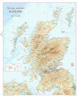
Scotland Wall Map
A wall map of Scotland at 1:650, 000 from Global Mapping, 70 x 89cm (2ft 4” x 2ft 11”), showing the country’s network of main roads and railways on a base with relief shading and altitude colouring, with names of numerous peaks, valleys, coastal lochs, bays and sounds, etc.The map also shows county/unitary authorities names and borders, airports, ferry connections and various places of tourist interest: historical sites, castles and palaces, gardens, golf courses, etc. Latitude and longitude lines are marked at 1° intervals.

Product Description
Reviews/Comments
Add New
Vouchers
No voucher codes found.
Do you know a voucher code for this product or supplier? Add it to Insights for others to use.
Do you know a voucher code for this product or supplier? Add it to Insights for others to use.
 Denmark