
 United Kingdom
 France
 Germany
 Netherlands
 Sweden
 USA
USA
 Italy
Italy
 Spain
Spain
More From Contributor


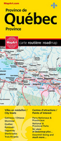
Québec Province MapArt
Quebec Province on an indexed, double-sided road map presenting its southern part in three panels. The main part of the province, from Montreal to Quebec City and Sherbooke, is covered at 1:500, 000. Two further panels at 1:1, 000, 000 extend coverage further west and east: westward to the Ontario border and eastwards to Saguenay and Rivière-du-Loup (so including Ottawa, Montreal and Quebec City) and northwards to the Assinica Nature Reserve, plus further eastwards along the St. Lawrence River beyond Rivière-du-Loup to include the Gaspé Peninsula and the northern coastline of the estuary.On the mapping at 1:500, 000 and 1, 000, 000 road and rail networks are presented on a base with colouring highlighting national/provincial parks. Road network indicates paved, loose surface and
unimproved roads, and shows driving distances on main and many local roads. Symbols show locations of campsites, visitor information centre, ski areas and various places of interest. The panels have no geographical coordinates and are covered by one combined index.Enlargements present in greater detail the environs of Montreal, Quebec City and Ottawa (all at 1:200, 000) plus at more detailed scales Sanguenay, Trois-Rivières, Sherbrooke and Ramouski. Also provided is a map of the whole Quebec Province indicating northern locations accessible by air transport, plus a distance table.To see the list of currently available Canadian province and regional maps form the MapArt / Canadian Cartographics Corporation / JDM Géo publishing group, including waterproof and tear-resistant
FastTrack titles, please click on the series link.

Product Description
Reviews/Comments
Add New
Vouchers
No voucher codes found.
Do you know a voucher code for this product or supplier? Add it to Insights for others to use.
Do you know a voucher code for this product or supplier? Add it to Insights for others to use.
 Denmark