
 United Kingdom
 France
 Germany
 Netherlands
 Sweden
 USA
USA
 Italy
Italy
 Spain
Spain
More From Contributor


Paris Red Maps
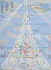
Central Paris plus Montmartre on a tourist street plan from Red Maps presented in a handy concertina format and printed on thick high quality paper, with thematic indexes for sights, hotels, shopping, etc.The plan covers Paris from Monet’s Marmottan Museum near the Bois de Boulogne to the Bastille Opera House and north/south from the St. Lazare station to the top of the Luxembourg Gardens. Rather than show its map scale as the traditional ratio, the publishers indicate coverage eat/west as 8.25 km/ 5.1 miles and north/south 4 km/2.5 miles (effectively 1:17, 625 approx). On the reverse a separate panel shows the Montmartre area.The plan names tourist sights and important buildings, entertainment venues, selected hotels, etc. Also highlighted are main shopping streets with names of
selected individual stores. Metro/RER stations and connections are very clearly indicated.Next to the main plan and on the reverse are thematic lists of sights and important buildings, hotels, etc. A special panel provides area-by-area recommendation of (mainly fashion) shops. A brief index lists a selection of neighbourhoods and streets/squares and a handful of metro or rail stations.To see other street plans from Red Maps with similar presentation please click on the series link.
selected individual stores. Metro/RER stations and connections are very clearly indicated.Next to the main plan and on the reverse are thematic lists of sights and important buildings, hotels, etc. A special panel provides area-by-area recommendation of (mainly fashion) shops. A brief index lists a selection of neighbourhoods and streets/squares and a handful of metro or rail stations.To see other street plans from Red Maps with similar presentation please click on the series link.

Product Description
Reviews/Comments
Add New
Vouchers
No voucher codes found.
Do you know a voucher code for this product or supplier? Add it to Insights for others to use.
Do you know a voucher code for this product or supplier? Add it to Insights for others to use.
 Denmark