More From Contributor

£3.99
Paris Pop-Out Map from Compass Maps in a series designed to provide two street plans, the city centre plus a wider area around it, in a handy format to fit neatly all but the smallest pockets, with, as appropriate, transport network diagrams, additional useful maps, etc. Each title ...
Archived Product
£9.95
This book contains 20 detachable postcards featuring leading fashion illustrator Jason Brooks stunning work from his Paris ...
Archived Product
£17.99
In this stunning volume of historical postcards featuring the City of Light, Leonard Pitt takes us deep into the art & heart ...
Archived Product
£17.99
Paris is the mecca of style. It is the Grand Dame of elegance. It is also an intimate fusion of culture & creativity. As the many movies & books tell us, Parisians know how to eat, drink & shop. Here`s your chance to find out where they go to eat, drink & shop.. .and maybe begin your own love affair with Paris! This book reveals the best eating, drinking & shopping across 15 Parisian precincts. Each precinct chapter

Includes::
an interview of a prominent Parisian from that precinct focussing on their favourite things to eat, drink & buy. Precinct maps make this a handy & useful guidebook, while the hardback cover creates a beautiful keepsake.

...
Archived Product
£11.99
DUE OUT MARCH 2014
- Paris in the Michelin Red Guides series; hotel & restaurant guides that have an unparalleled reputation for
...
Archived Product
£10.99
Paris in the Michelin Red Guides series; hotel & restaurant guides that have an unparalleled reputation for reliability & consistency, making extensive use of keyed information to provide detailed & concise reviews. Guides are predominantly intended for the markets they are reviewing &, as such, are more often than not written in the native language (s) of their featured destination, that said, most foreign language guides do come with a range of English language introductory & explanatory information such as thorough details on how to use the guide & a description of its symbol classifications. The obvious exceptions to this structure are locations which already have English as their official language. Guides feature hundreds of hotels and/or restaurants & rate them according to the time honoured Michelin standards. Reviews are arranged alphabetically by location & introduce places & establishments, providing you with details of other relevant Michelin publications, situating the businesses & detailing facilities & services, as well as the all important price range. Establishment descriptions look at the atmosphere, d ...
Archived Product
£9.99
Central Paris plus Montmartre on a tourist street plan from Red Maps presented in a handy concertina format & printed on thick high quality paper, with thematic indexes for sights, hotels, shopping, etc. The plan covers Paris from Monet’s Marmottan Museum near the Bois de Boulogne to the Bastille Opera House & north/south from the St. Lazare station to the top of the Luxembourg Gardens. Rather than show its map scale as the traditional ratio, the publishers indicate coverage eat/west as 8.25 km/ 5.1 miles & north/south 4 km/2.5 miles (effectively 1:17, 625 approx). On the reverse a separate panel shows the Montmartre area. The plan names tourist sights & important buildings, entertainment venues, selected hotels, etc. Also highlighted are main shopping streets with names of selected individual stores. Metro/RER stations & connections are very clearly indicated. Next to the main plan & on the reverse are thematic lists of sights & important buildings, hotels, etc. A special panel provides area-by-area recommendation of (mainly fashion) shops. A brief index lists a selection of neighbourhoods & streets/squares & a handful of metro or rail stations. To see other street plans from Red Maps with similar presentation please click on the series link. ...
Archived Product
£5.59
Paris Rediscovered in the Encounter Guide Series from Lonely Planet, exploring a range of cities & regions worldwide in a handy, pocket-sized format designed to introduce visitors to the distinctive neighbourhoods of the destination. Frank & informal in style, the guides are renowned for their appeal to independent travellers & are written & researched by local authors. Each guide is organised into 5 distinct sections
- Highlights, Diary, Itineraries, Neighbourhoods & Snapshots
- recommending a series of essential encounters for visitors to the region. Each guide opens with a

...
Archived Product
£10.99
Take an insiders tour of one of the worlds greatest culinary centres or browse through the mouthwatering restaurant options in this handy guide. Based on the opinions of thousands of avid restaurant-goers, this guide

Includes::
ratings & reviews for 1, 000 of the best restaurants in & around the French capital. The trademark reviews & corresponding ratings for Food, Decor, Service & Cost are organized alphabetically in a user-friendly format. Use the indexes arranged by cuisine, neighborhood & special features like In Places, Winning Wine Lists or Romantic Places to find the perfect restaurant for any occasion.

...
Archived Product

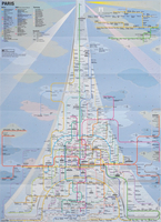
Paris Railway System Map

The inspiration for the design of Paris Railway System came from the Eiffel Tower, a Parisian symbol. On this map, the Seine sketches the arch and silhouette of the Eiffel Tower, upon which the Parisian railway combination of Metro, RER and Tram are laid, filling in the body of the Eiffel Tower. The beams of searchlights zooming out from the very top of the Eiffel Tower and the clouds representing the zone system mingle with the railway map to complete the nightscape of Paris.City Railway System is a new approach to projecting the identity of a city onto its subway map. Whereas conventional subway maps aim at conveying information as clearly and concisely as possible, the City Railway System by Zero Per Zero instinctively incorporates symbolic elements of each city into its map while
preserving clarity. As a special consideration for tourists, major landmarks and tourist attractions are indicated on the subway maps, so that tourists can easily figure out the fastest way to get to the destination at a glance. The railway map itself is also good as a souvenir.
RIP - This product is no longer available on our network. It was last seen on 25.09.2019

This page now acts as a permanent archive for this product. Add more information using the comments box below to ensure it can still be found by future generations.

Use our search facility to see if it is available from an alternative contributor.
  • Availability: Out Of Stock
  • Supplier: Stanfords
  • SKU: 9786000514389
Availability: In Stock
£8.99

Product Description

The inspiration for the design of Paris Railway System came from the Eiffel Tower, a Parisian symbol. On this map, the Seine sketches the arch & silhouette of the Eiffel Tower, upon which the Parisian railway combination of Metro, RER & Tram are laid, filling in the body of the Eiffel Tower. The beams of searchlights zooming out from the very top of the Eiffel Tower & the clouds representing the zone system mingle with the railway map to complete the nightscape of Paris. City Railway System is a new approach to projecting the identity of a city onto its subway map. Whereas conventional subway maps aim at conveying information as clearly & concisely as possible, the City Railway System by Zero Per Zero instinctively incorporates symbolic elements of each city into its map while preserving clarity. As a special consideration for tourists, major landmarks & tourist attractions are indicated on the subway maps, so that tourists can easily figure out the quickest way to get to the destination at a glance. The railway map itself is also good as a souvenir.

Reviews/Comments

Add New

Intelligent Comparison

Oooops!
We couldn't find anything!
Perhaps this product's unique.... Or perhaps we are still looking for comparisons!
Click to bump this page and we'll hurry up.

Price History

Vouchers

No voucher codes found.
Do you know a voucher code for this product or supplier? Add it to Insights for others to use.

Facebook

Jargon Buster

Tram - A large vehicle common in cities for public transport, also known as a cable car.
Design - A drawing or styles that shows the look and functionality of something before its made.
Combination - The process of two of more things being mixed or combined together.

Supplier Information

Stanfords
Stanfords was established in 1853 and opened their iconic Covent Garden flagship store in 1901. They have become the top retailer of maps, travel books and accessories in the UK and arguably offer the largest selection of maps and travel books worldwide. Famous names such as Captain Robert Falcon Scott, Ranulph Fiennes and Michael Palin have purchased from Stanfords. They now have a shop in Bristol and both stores together with other venues operate a calendar of events including talks, book signings and exhibitions. As a specialist map retailer, the map selection is comprehensive and includes road maps, street maps and walking maps from worldwide destinations, as well as a selection of world atlases and wall maps. Books include travel guides and travel literature. Stanfords also stock globes, from miniatures made of blue marble to magnificent floor-standing globes. The website features a selection of interesting articles on travel topics.
Page Updated: 2023-11-12 20:15:36

Community Generated Product Tags

Oh No! The productWIKI community hasn't generated any tags for this product yet!
Menu