
 United Kingdom
 France
 Germany
 Netherlands
 Sweden
 USA
USA
 Italy
Italy
 Spain
Spain
More From Contributor


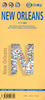
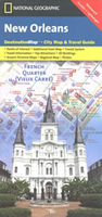
New Orleans
New Orleans on a light, waterproof and tear-resistant tourist map from the National Geographic combining a street plan of the city’s central districts with road maps of the environs and the Louisiana plantations, plan of the airport, tourist information, etc.On one side is a street plan of the city’s central districts, including the French Quarter, Central Business District with the Louisiana Superdome, the Warehouse / Arts district and the Garden district. Important public buildings and numerous hotels are highlighted and named. Tramway lines are shown with stops and also indicated is the route of Vieux Carré shuttle and the ferry across the Mississippi. The index on the reverse lists districts, streets, parks and cemeteries, piers and wharfs, hotels, and public
buildings.The reverse side also includes two road maps: the environs of the city, plus a wider region extending beyond Baton Rouge and highlighting Louisiana’s Old South plantations. Accompanying notes provide more information about the plantations as well as about the sights within the city. Also provided is a plan showing road access to and the layout of the Louis Armstrong International Airport with notes on transport to the city centre.
buildings.The reverse side also includes two road maps: the environs of the city, plus a wider region extending beyond Baton Rouge and highlighting Louisiana’s Old South plantations. Accompanying notes provide more information about the plantations as well as about the sights within the city. Also provided is a plan showing road access to and the layout of the Louis Armstrong International Airport with notes on transport to the city centre.

Product Description
Reviews/Comments
Add New
Vouchers
No voucher codes found.
Do you know a voucher code for this product or supplier? Add it to Insights for others to use.
Do you know a voucher code for this product or supplier? Add it to Insights for others to use.
 Denmark