
 United Kingdom
 France
 Germany
 Netherlands
 Sweden
 USA
USA
 Italy
Italy
 Spain
Spain
More From Contributor


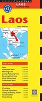
Laos Periplus Travel Map
Laos at 1:2, 000, 000 from Periplus with more detailed enlargements of several most visited areas, plus indexed street plans of the country’s main cities: Vientiane Luang Prabang, Savannakhet, Vang Vieng and Pakxe.On one side is a general map of the whole country showing its road and rail networks. Local airports are marked and numerous places of interest, including historical sites and national parks, are highlighted. The map also shows the country’s internal administrative boundaries with names of the provinces. Coverage extends to the Gulf of Tonkin to include a large part of northern and central Vietnam with Hanoi and Da Nang. Latitude and longitude lines are drawn at intervals of 1º.The map is accompanied by more detailed enlargements of the county’s most visited areas:
the areas around Vientiane and Savannakhet (both at 1:100, 000), the areas around Luang Prabang and Vang Vieng (both at 1:1:150, 000), plus the Pain of Jars and the Mekong Falls (both at 1:200, 000). Neither the main map nor the enlargements are indexed.On the reverse are indexed street plan of the country’s five main cities: Vientiane Luang Prabang, Savannakhet, Vang Vieng and Pakxe, all extensively annotated with accommodation, various tourist facilities and places of interest. Central Vientiane is also presented on a separate, more detailed plan.
the areas around Vientiane and Savannakhet (both at 1:100, 000), the areas around Luang Prabang and Vang Vieng (both at 1:1:150, 000), plus the Pain of Jars and the Mekong Falls (both at 1:200, 000). Neither the main map nor the enlargements are indexed.On the reverse are indexed street plan of the country’s five main cities: Vientiane Luang Prabang, Savannakhet, Vang Vieng and Pakxe, all extensively annotated with accommodation, various tourist facilities and places of interest. Central Vientiane is also presented on a separate, more detailed plan.

Product Description
Reviews/Comments
Add New
Vouchers
No voucher codes found.
Do you know a voucher code for this product or supplier? Add it to Insights for others to use.
Do you know a voucher code for this product or supplier? Add it to Insights for others to use.
 Denmark