
 United Kingdom
 France
 Germany
 Netherlands
 Sweden
 USA
USA
 Italy
Italy
 Spain
Spain
More From Contributor


Kazakhstan (Geographical Edition)
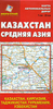
Kazakhstan at 1:3, 000, 000 from Gizi Map with bold altitude colouring providing an excellent picture of the country’s topography, an index of localities on the reverse, and good coverage of the adjoining regions: the map extends well beyond Kazakhstan’s borders to include the other four Central Asian countries (Uzbekistan, Kyrgyzstan, Tajikistan and Turkmenistan), as well as part of western China, Pakistan north of Islamabad/Rawalpindi/Peshawar, the northern half of Afghanistan with Kabul, a large part of Iran with Teheran and Isfahan, the whole of the Caspian Sea, plus the border region of Russia from Volgograd to Novosibirsk. All place names are in the Latin alphabet.The map shows the region’s rail and road networks, including dirt tracks, and gives driving distances
on major routes. Local airports are marked and the map shows names and boundaries of Kazakhstan’s administrative provinces. Vivid presentation of the topography through bold altitude colouring includes graphics for deserts, swamps and salt flats, with plenty of names of mountain ranges, peaks, etc. National parks are highlighted, as are the various routes of the Silk Road. Latitude and longitude lines are drawn at 2° intervals. The index, separate for each country covered by the map, is on the reverse. Map legend includes English.PLEASE NOTE: the same map but with slightly reduced coverage of western China is also available in a political edition where the altitude colouring has been replaced by a different colour for each country. The political version also includes a street
plan of Astana. Both the geographical and the political versions are also available as wall maps.
 "Pin It")
Product Description
Reviews/Comments
Add New
Vouchers
No voucher codes found.
Do you know a voucher code for this product or supplier? Add it to Insights for others to use.
Do you know a voucher code for this product or supplier? Add it to Insights for others to use.
 Denmark