
 United Kingdom
 France
 Germany
 Netherlands
 Sweden
 USA
USA
 Italy
Italy
 Spain
Spain
More From Contributor

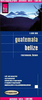
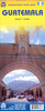
Guatemala And Belize
Guatemala and Belize at 1:500, 000 on an indexed, waterproof and tear-resistant road map with topographic and tourist information, published by Reise Know-How as part of their highly acclaimed World Mapping Project. The map is double-sided to provide the best balance between a good scale and a convenient size sheet.The map divides the region north/south, with the whole of Belize on one side. On the southern side coverage includes much of El Salvador with San Salvador, and the westernmost part of Honduras. Topography is presented by altitude colouring and spot heights with names of mountain ranges, peaks, etc. Swamp areas, seasonal rivers and lakes, and along the coast coral reefs are also indicated. National parks and other protected areas are highlighted.Road network indicates
toll routes, includes selected local roads and tracks, and shows border crossings and distances on main routes. Railway lines are included and local airports are marked. Internal administrative boundaries are shown with names of the provinces. Symbols indicate numerous places of interest, including UNESCO world heritage sites, archaeological sites, caves, beaches, etc. The map has a latitude and longitude grid at intervals of 30
toll routes, includes selected local roads and tracks, and shows border crossings and distances on main routes. Railway lines are included and local airports are marked. Internal administrative boundaries are shown with names of the provinces. Symbols indicate numerous places of interest, including UNESCO world heritage sites, archaeological sites, caves, beaches, etc. The map has a latitude and longitude grid at intervals of 30
Product Description
Reviews/Comments
Add New
Vouchers
No voucher codes found.
Do you know a voucher code for this product or supplier? Add it to Insights for others to use.
Do you know a voucher code for this product or supplier? Add it to Insights for others to use.
 Denmark