
 United Kingdom
 France
 Germany
 Netherlands
 Sweden
 USA
USA
 Italy
Italy
 Spain
Spain
More From Contributor


Chile - Patagonia Nelles
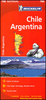
Chile at 1:2, 500, 000 from Nelles Verlag, on a double-sided map with coverage including southern Argentina. The map also provides six street plans and enlargements for the environs of Santiago, Torres del Paine and Peninsula Valdes.The northern part of the map starts at Arequipa and La Paz and extends south beyond Santiago to Talca, covering the adjoining parts of Peru, Bolivia and Argentina; on the reverse is the whole of the Chilean and Argentinian Patagonia. Bold relief shading with plenty of names of various peaks and glaciers, plus additional spot heights shows the topography. Numerous national parks and other protected area are highlighted.Road network distinguishes between mainly and partly surfaced highways, and shows distances on main routes. Railway lines and local
airports are included, as are the shipping routes from Puerto Montt down the Patagonian fjords. The map also shows internal administrative boundaries in both counties. Various places of interest are prominently marked. Latitude and longitude margin ticks are at 2° intervals. The map has no index of localities. Map legend includes English.Enlargements show in greater details the environs of Santiago and Torres del Paine, plus Peninsula Valdes in Argentina. Also included are street plans, additionally annotated with selected hotels, covering central Santiago, Arica, Antofagasta, Iquique, La Serena and Punta Arenas, plus a map of the Easter Island.
airports are included, as are the shipping routes from Puerto Montt down the Patagonian fjords. The map also shows internal administrative boundaries in both counties. Various places of interest are prominently marked. Latitude and longitude margin ticks are at 2° intervals. The map has no index of localities. Map legend includes English.Enlargements show in greater details the environs of Santiago and Torres del Paine, plus Peninsula Valdes in Argentina. Also included are street plans, additionally annotated with selected hotels, covering central Santiago, Arica, Antofagasta, Iquique, La Serena and Punta Arenas, plus a map of the Easter Island.

Product Description
Reviews/Comments
Add New
Vouchers
No voucher codes found.
Do you know a voucher code for this product or supplier? Add it to Insights for others to use.
Do you know a voucher code for this product or supplier? Add it to Insights for others to use.
 Denmark