
 United Kingdom
 France
 Germany
 Netherlands
 Sweden
 USA
USA
 Italy
Italy
 Spain
Spain
More From Contributor
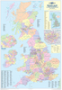
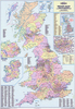

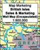


British Isles: Map Marketing Sales & Marketing Wall Map PAPER
Sales and Marketing Wall Map of the British Isles, size 83 x 120cm (33” x 47” approx) – paper version, from Map Marketing showing county and unitary authorities names and boundaries, plus additional information for the United Kingdom on postcode areas, TV coverage, etc.The map shows the UK at 1:800, 000, with the whole of Ireland included as an inset at half the scale (1:1, 600, 000). Boundaries and names of counties and unitary authorities are overprinted on a base showing the network of motorways and A roads, with domestic and international airports also marked. London area is presented in greater detail on an enlargement.Additional maps and lists provide information only for the United Kingdom (i.e. the Republic of Ireland is not covered):- a map plus a list of postcode
areas- a map showing TV regions listing the number of homes in each area- a list of counties and unitary authorities with population figuresPLEASE NOTE: this map is also available encapsulated
areas- a map showing TV regions listing the number of homes in each area- a list of counties and unitary authorities with population figuresPLEASE NOTE: this map is also available encapsulated

Product Description
Reviews/Comments
Add New
Vouchers
No voucher codes found.
Do you know a voucher code for this product or supplier? Add it to Insights for others to use.
Do you know a voucher code for this product or supplier? Add it to Insights for others to use.
 Denmark