
 United Kingdom
 France
 Germany
 Netherlands
 Sweden
 USA
USA
 Italy
Italy
 Spain
Spain
More From Contributor

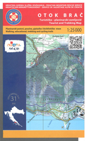
Brac Island
The island of Brac on the Adriatic coast of Croatia on a contoured and GPS compatible map at 1:25, 000 from the Croatian Mountain Rescue Service, highlighting recommended cycling routes, with 26 routes profiles. The island is shown on both sides of the map with similar cartography (contours at 10m intervals enhanced by relief shading to provide excellent presentation of the terrain) but with different cycling information. On one side, additional colouring and graphics show the vegetation. Recommended cycle routes are prominently highlighted and indicate distances. Symbols show various facilities and places of interest: tourist accommodation including campsites, restaurants, bike rental and repair, cultural monuments and nature highlights, etc. The map has a 1km UTM grid. On the
reverse the same map is shown with contours and relief shading but, for greater clarity, without the vegetation colouring, cycling distances and tourist symbols. The routes are still highlighted but instead are annotated in several places with icons showing the degree of difficulty and required technical skills.26 panels on both sides of the map provide details of each trail and their route profiles. Map legend and all the text include English.To see the list of titles in this series please click on the series link.
reverse the same map is shown with contours and relief shading but, for greater clarity, without the vegetation colouring, cycling distances and tourist symbols. The routes are still highlighted but instead are annotated in several places with icons showing the degree of difficulty and required technical skills.26 panels on both sides of the map provide details of each trail and their route profiles. Map legend and all the text include English.To see the list of titles in this series please click on the series link.

Product Description
Reviews/Comments
Add New
Vouchers
No voucher codes found.
Do you know a voucher code for this product or supplier? Add it to Insights for others to use.
Do you know a voucher code for this product or supplier? Add it to Insights for others to use.
 Denmark