
 United Kingdom
 France
 Germany
 Netherlands
 Sweden
 USA
USA
 Italy
Italy
 Spain
Spain
More From Contributor


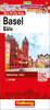
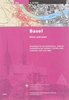

Basel Pocket Street Plan
Basel on a handy size, indexed street plan from Orell Füssli, covering the city’s inner districts at 1:12, 000 with the historic centre shown in greater detail. On the reverse are multilingual notes about the city and its main sights.Tram and bus routes are shown with stops and line numbers and S-Bahn lines and stations are clearly marked. Symbols mark locations of various sights, cultural institutions, car parks, places of worship, etc. The city centre in shown in greater detail at 1:8, 000.Street index is on the reverse together with brief notes about the city and its main sights. Map legend and the text include English.

Product Description
Reviews/Comments
Add New
Vouchers
No voucher codes found.
Do you know a voucher code for this product or supplier? Add it to Insights for others to use.
Do you know a voucher code for this product or supplier? Add it to Insights for others to use.
 Denmark