More From Contributor

£8.99
Mannheim on a topographic map at 1:200, 000 from the Bundesamt für Kartographie und Geodäsie, Germany’s federal mapping agency. The map covers an area of Approx. 100 x 90km. This map is belongs to a series of 58 topographic maps from Bundesamt für Kartographie und Geodäsie, the federal cartographic agency of Germany responsible for topographic mapping at 1:200, 000 & maps at smaller scales (the more detailed topographic & leisure maps are prepared & published by the survey organizations of the individual states). Cartography is from the 200K topographic survey & the maps have very elegant, modern look whilst retaining the traditional German presentation of names of smaller towns & villages in italics. Contours are at 12, 5m intervals, enhanced by relief shading, with colouring for woodlands, moors, marches, vineyards & hop plantations. Waterways & rivers are also described in detail, with currents, waterfalls, dams, & jetties clearly marked. Road network, graded into five types, highlights in colour national & regional roads; no driving distances are marked Railway network is also shown in detail, with stations, goods only lines, etc. The maps show administrative boundaries of states & counties, & have a UTM grid plus margin ticks for latitude & longitude at 2’ intervals. Map legend is in German only. PLEASE NOTE: maps in this series provide an excellent presentation of the areas covered by them, with plenty of place names & detailed representation of the road network, & will appeal to anyone who likes quality cartography, but they are not necessarily the best option for holiday & business travel. To see other titles in this series please click on the series link. ...
Archived Product
£9.50
One of the titles in a series of double-sided topographic maps with hiking routes & tourist information. Cartography is identical to the standard topographic survey of Germany, with contours at 10m intervals. Extensive overprint highlights numerous local footpaths & long-distance hiking routes, indicating waymarking. Cycling routes, mountain bike centres & trails, & cross-country ski routes are also marked. Extensive range of symbols highlight sport & leisure facilities, various types of accommodation, places of interest, tourist railways, etc. Boundaries of national parks & nature reserves are marked. The maps have a 2km UTM grid. Map legend

Includes::
English. The maps also have lists of contact details of various organizations & facilities within the region, plus brief descriptions in German only.

...
Archived Product
£5.50
ADAC, Germany's equivalent of the British Automobile Association publishes an extensive series of street plans which provide detailed high-quality mapping of all the major towns & cities, including their outer suburbs. The plans name all the individual streets & indicate all the main landmarks & public buildings. All public transport facilities are shown: buses, trams, underground & overland rail lines. One way streets & car parks are indicated. Plans of larger cities include an enlargement for the city centre. The plans also show the administrative & postal divisions & have an extensive street index which, where appropriate, shows individual postal codes for each street. On the reverse, each plan has a road map at 1:100, 000, covering a very wide area around the city. Map legend

Includes::
English.

...
Archived Product
£7.99
Falk, one of Germany`s leading publishers of street plans, produce their town plans in two different formats. Falk Extra plans are folded in a standard way, where the whole map can be opened to view the entire area it covers. For larger cities, the same mapping is also published with a special folding system designed to show only a small section of the map at one time. The whole map can be opened but it will be cut in several places. Many find these street plans very user-friendly & easier to handle than conventional maps. The plans, which cover towns with their outer suburbs, indicate main landmarks & public buildings & show all the public transport facilities, one way streets & car parks. Plans of lager cities include a separate map of the town centre at a more detailed scale & a diagram of the underground & the suburban rail network. The plans also show the postal divisions & have an extensive street index which, where appropriate, shows individual postal codes for each street. Map legend

Includes::
English. Falk Extra plans also include on the reverse a road map of the surrounding area.

...
Archived Product
£9.99
Street plan of the Mannheim
- Ludwigshafen conurbation in Falk’s Special Fold format, designed to show only a small section of
...
Archived Product
£2.95
Manningtree & Mistley in 1896 in a fascinating series of reproductions of old Ordnance Survey plans in the Alan Godfrey Editions, ideal for anyone interested in the history of their neighbourhood or family. Selected towns in Great Britain & Ireland are covered by maps showing the extent of urban development in the last decades of the 19th & early 20th century. In this title: the map covers the two villages of Manningtree & Mistley, with coverage stretching from Lawford Hill & Marsh Row eastward to New Mistley. Features include the village centres of both communities, a stretch of the GER Harwich branch with Mistley station, Brunswick House (lunatic asylum), Mistley Green, St Mary's church Mistley, Baltic Wharf, Furze Hill, Dairy House, Hopping Bridge, numerous mathouses in both villages, Mistley Hall, Barnfield House, Manningtree Channel, Middlebridge Creek, Mistley Park. Stretches of the River Stour & Irelandhole Reach are shown, surrounded by mud. Directories for both villages are given on the back. About the Alan Godfrey Editions of the 25 ...
Archived Product
£14.99
This is a unique, practical, hands-on guide to boat manoeuvring
- ideal for cockpit use or as an aide-memoire. Manoeuvring a
...
Archived Product
£7.99
Manon Lescaut is a ground-breaking novel of passion & immorality, & one of the most famous love stories of all time. The Chevalier des Grieux is still a young man, but already life & bitter experience have worn him to a shell. The kindness of a stranger persuades him to reveal his troubles, the story of his helpless & ill-starred love for Manon, & the mutually destructive affair which has given him, in turn, the joy of sexual love & the misery of betrayal & moral degradation. First published in 1731, Prevost`s story proved to be hugely influential, its passionate & tragic mode inspiring a number of operas & ballets, while the compelling character of Manon prefigures a host of nineteenth-century Romantic heroines. ...
Archived Product
£3.50
Manorhamilton in 1908 in a fascinating series of reproductions of old Ordnance Survey plans in the Alan Godfrey Editions, ideal for anyone interested in the history of their neighbourhood or family. The map is double-sided. Most of the town of Manorhamilton is shown, & coverage extends eastward to Curley Bridge & the station. The main map covers the Main Street area of town, where features also include church, ruined church, Sycamore Lodge, Owenmore River, St Clare`s Hall, Workhouse, railway with station, engine shed & full track layout, part of Donagh More district, Ramooney district, Curley Bridge. On the reverse is part of the adjacent sheet 7.16 extending coverage north, & this

Includes::
Fair Green, ruined castle, St Clare`s RC church, Sheela More`s Bridge, Bee Park, etc. Skreeny House is just cut off by the margin. Also included is a trade directory for Manorhamilton in c.1910. About the Alan Godfrey Editions of the 25” OS Series: Selected towns in Great Britain & Ireland are covered by maps showing the extent of urban development in the last decades of the 19th & early 20th century. The plans have been taken from the Ordnance Survey mapping & reprinted at about 15 inches to one mile (1:4, 340). On the reverse most maps have historical notes & many also include extracts from contemporary directories. Most maps cover about one mile (1.6kms) north/south, one & a half miles (2.4kms) across; adjoining sheets can be combined to provide wider coverage.FOR MORE INFORMATION & A COMPLETE LIST OF ALL AVAILABLE TITLES PLEASE CLICK ON THE SERIES LINK.

...
Archived Product
£12.99
Topographic survey of France at 1:25, 000 in IGN`s excellent TOP25 / Série Bleue series. All the maps are GPS compatible, with a 1km UTM grid plus latitude & longitude lines at 5’ intervals. Contours are at 5m intervals except for mountainous areas where the maps have contours at 10m intervals, vividly enhanced by hill shading & graphics for rocky terrain. Colouring with graphics indicates different types of vegetation or land use (deciduous or coniferous forests, moors, orchards, vineyards, etc). PLEASE NOTE: coverage of France at this scale is currently being revised – the format & the presentation of each title are indicated by the letters at the end of its Sheet Reference number (e.g. 0416ET, 3531ETR, 1923SB, etc.)MAPS WITH FULL TOURIST OVERPRINT & AN ENGLISH MAP LEGEND: all TOP25 maps & the SB editions of Série Bleue have an overprint highlighting waymarked walking trails including long-distance GR routes &, where appropriate, ski routes. Symbols indicate campsites, gîtes d’etape, refuges, equestrian centres & other recreational facilities or sites, tourist information centres, cultural heritage, etc. Towns & locations of particular interest are highlighted.- ET or OT = single-sided TOP25 map covering approx. 29x 21 km / 18x 13 miles.- ETR or OTR = waterproof & tear resistant TOP25 map covering the same area as the corresponding ET or OT number, but double-sided, printed on a smaller size sheet with a good overlap between the sides.- SB = Série Bleue map with full tourist overprint; these maps, first introduced in summer 2014, each cover approx. 29x 24km / 18x 15 miles.SÉRIE BLEUE maps with numbers ending in E (Est) or O (Ouest): most editions now indicate the GR routes, but do not show any other tourist information. Map legend is in French only. Each map covers approx. 14x 20km / 9x 12 miles. ...
Archived Product

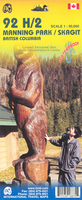
Manning Park - Skagit River ITMB

Manning Park - Skagit River at 1:50, 000 in a series of topographic survey maps of selected areas of British Columbia and the Canadian Rockies from ITMB with cartography from Canada’s national survey organization. Most sheets are printed on light, waterproof and tear- resistant plastic paper.Whilst the Canadian Department of Natural Resources (previously Canada Map Office) decides whether to provide updated pre-printed editions of its survey mapping or switch to print-on-demand only, in 2007 it began co-operating with ITMB on this new series of maps with cartography of the Canadian topographic survey and additional tourist and recreational information provided by ITMB. The maps are double-sided, with either two 1:50, 000 maps combined in one title, or a 1:250, 000 map supplemented by
more detailed coverage at 1:50, 000. *In this title:* contours at 100 feet intervals, with a UTM grid and margin ticks for latitude and longitude. Overprint highlights Trans-Canada trail and other paths, as well as various areas and facilities for horse riding, skiing, canoeing and climbing. Also indicated are accommodation facilities, shelters, RV sites and campsites, and wilderness camps. The map is printed on light, waterproof and tear-resistant plastic paper.
RIP - This product is no longer available on our network. It was last seen on 25.09.2019

This page now acts as a permanent archive for this product. Add more information using the comments box below to ensure it can still be found by future generations.

Use our search facility to see if it is available from an alternative contributor.
  • Availability: Out Of Stock
  • Supplier: Stanfords
  • SKU: 9781553418870
Availability: In Stock
£9.99

Product Description

Manning Park
- Skagit River at 1:50, 000 in a series of topographic survey maps of selected areas of British Columbia & the Canadian Rockies from ITMB with cartography from Canada’s national survey organization. Most sheets are printed on light, waterproof & tear- resistant plastic paper. Whilst the Canadian Department of Natural Resources (previously Canada Map Office) decides whether to provide updated pre-printed editions of its survey mapping or switch to print-on-demand only, in 2007 it began co-operating with ITMB on this new series of maps with cartography of the Canadian topographic survey & additional tourist & recreational information provided by ITMB. The maps are double-sided, with either two 1:50, 000 maps combined in one title, or a 1:250, 000 map supplemented by more detailed coverage at 1:50, 000. * In this title:* contours at 100 feet intervals, with a UTM grid & margin ticks for latitude & longitude. Overprint highlights Trans-Canada trail & other paths, as well as various areas & facilities for horse riding, skiing, canoeing & climbing. Also indicated are accommodation facilities, shelters, RV sites & campsites, & wilderness camps. The map is printed on light, waterproof & tear-resistant plastic paper.

Reviews/Comments

Add New

Intelligent Comparison

Oooops!
We couldn't find anything!
Perhaps this product's unique.... Or perhaps we are still looking for comparisons!
Click to bump this page and we'll hurry up.

Price History

Vouchers

No voucher codes found.
Do you know a voucher code for this product or supplier? Add it to Insights for others to use.

Facebook

Jargon Buster

Paper - A thin sheet mainly used for writing. Available in a variety of colours. Made mainly from wood pulp.
Plastic - A generic term for a synthetic product used in the manufacture of products
Waterproof - Resistant to water, usualy specified by depth in metres
Office - A room where people work
Natural - not manmade
Resistant - Something that can repel against something.
Horse - A large animal with four legs that tends to be ridden.
Accommodation - A room in which someone can live in, for example in a hotel
Print - A mechanical process of putting text onto paper. It can also relate to a pattern on an item.

Supplier Information

Stanfords
Stanfords was established in 1853 and opened their iconic Covent Garden flagship store in 1901. They have become the top retailer of maps, travel books and accessories in the UK and arguably offer the largest selection of maps and travel books worldwide. Famous names such as Captain Robert Falcon Scott, Ranulph Fiennes and Michael Palin have purchased from Stanfords. They now have a shop in Bristol and both stores together with other venues operate a calendar of events including talks, book signings and exhibitions. As a specialist map retailer, the map selection is comprehensive and includes road maps, street maps and walking maps from worldwide destinations, as well as a selection of world atlases and wall maps. Books include travel guides and travel literature. Stanfords also stock globes, from miniatures made of blue marble to magnificent floor-standing globes. The website features a selection of interesting articles on travel topics.
Page Updated: 2023-11-12 20:15:36

Community Generated Product Tags

Oh No! The productWIKI community hasn't generated any tags for this product yet!
Menu