
 United Kingdom
 France
 Germany
 Netherlands
 Sweden
 USA
USA
 Italy
Italy
 Spain
Spain
More From Contributor


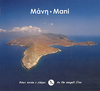


Mani Anavasi 8.4
The Mani Peninsula at 1:50, 000 on light, waterproof and tear-resistant, contoured and GPS compatible map from Anavasi, showing local footpaths including descriptions for eight specially selected routes, etc. The map is double-sided, dividing the peninsula north/south with a very generous overlap between the sides.Topography is vividly presented by contours at 20m intervals, plus relief shading and sport heights. Road network indicates dirt roads in poor condition, driving distances on minor roads, and locations of petrol station. Also marked are stops of the local bus services. The marking for country tracks and footpaths distinguishes between well defined and narrow or faint routes. Eight recommended hiking trails are prominently highlighted and cross-referenced to brief
descriptions.Symbols highlight locations of hotels, campsites, tavernas, beaches, archaeological remains and various other places of interest. The map has a 1km UTN grid plus cross-hairs for latitude and longitude at intervals of 1’. Map legend and the text include English.To see the list of other titles in this series please click on the series link.
descriptions.Symbols highlight locations of hotels, campsites, tavernas, beaches, archaeological remains and various other places of interest. The map has a 1km UTN grid plus cross-hairs for latitude and longitude at intervals of 1’. Map legend and the text include English.To see the list of other titles in this series please click on the series link.

Product Description
Reviews/Comments
Add New
Vouchers
No voucher codes found.
Do you know a voucher code for this product or supplier? Add it to Insights for others to use.
Do you know a voucher code for this product or supplier? Add it to Insights for others to use.
 Denmark