More From Contributor
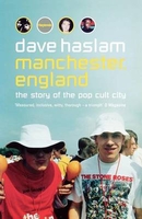
£8.99
Manchester Central in the Cassini Past & Present map series which covers town & cities of England & Wales & offers a unique way of tracing their history & expansion by showing four different periods of their development using Ordnance Survey mapping from the mid-19th century, the late 19th century, the 1920s & the present day. Coverage

Includes::
Droylesden, Eccles, Failsworth, Pendlebury, Prestwich, Reddish, Sale, Salford & Stretford. Each Past & Present map consists of four panels, all centred on a city or a town & covering exactly the same 15km x 15km area. Three of the panels reproduce Ordnance Survey

...
Archived Product
£3.50
Manchester’s city centre in 1849 in a series of exceptionally detailed reproductions of old Ordnance Survey street plans for areas of larger cities which have undergone substantial redevelopment in the late 19th or the early 20th century, published in the Alan Godfrey Editions. The plans, printed in back & white, have been taken from the original Ordnance Survey mapping at 1:1, 056 & reproduced at 1:1, 760 – the equivalent of 36 inches (or one yard) to a mile. The maps provide an unrivalled, house-by-house picture of streets & individual buildings with inner courtyards, outbuildings, pavements, covered passages, etc. Many important institutions are named; within the National Galley on Trafalgar Square even the individual rooms (the map is from 1871, so no French Impressionists as yet!). On the reverse are historical notes about the area covered by the map, plus extracts from contemporary street directories. These maps provide a fascinating addition to Alan Godfrey’s huge series of some 2, 000 titles presenting reproductions of street plans at taken from the Ordnance Survey mapping at 1:2, 500 (25” to 1 mile) & reprinted at about 15 inches to one mile (1:4, 340). ...
Archived Product
£2.95
Manchester Clayton 1932 in a fascinating series of reproductions of old Ordnance Survey plans in the Alan Godfrey Editions, ideal for anyone interested in the history of their neighbourhood or family. Selected towns in Great Britain & Ireland are covered by maps showing the extent of urban development in the last decades of the 19th & early 20th century. In this title: the map covers an area on the east side of Manchester which

Includes::
Philips Park & Clayton. Coverage stretches from Forge Lane eastward to Edge Lane, & from Oldfield Street northward to Rose Bank Road. The LMS line runs across the northern part of the map, including Park station & Clayton Bridge station. Other features include the mineral line south to electricity generating station, Manchester & Ashton Canal, River Medlock, Bradford Colliery, Bradford Iron Works, Clayton Finishing Works, Clayton Hall, St Cross church, Clayton Aniline Chemical Works, tramways, Culcheth, Victoria Rubber Works, Bank Bridge Works, Philips Park, Philips Park Cemetery, Avro Aeroplane Works, Park Engineering Works, etc. On the reverse are street directory entries for Bank Street, Berry Brow, Clayton Lane & Street, Forge Lane, Melbourne Street, Stuart Street. About the Alan Godfrey Editions of the 25

...
Archived Product
£3.50
Manchester Clayton 1932 in a fascinating series of reproductions of old Ordnance Survey plans in the Alan Godfrey Editions, ideal for anyone interested in the history of their neighbourhood or family. The map covers an area on the east side of Manchester which

Includes::
Philips Park & Clayton. Coverage stretches from Forge Lane eastward to Edge Lane, & from Oldfield Street northward to Rose Bank Road. The LMS line runs across the northern part of the map, including Park station & Clayton Bridge station. Other features include the mineral line south to electricity generating station, Manchester & Ashton Canal, River Medlock, Bradford Colliery, Bradford Iron Works, Clayton Finishing Works, Clayton Hall, St Cross church, Clayton Aniline Chemical Works, tramways, Culcheth, Victoria Rubber Works, Bank Bridge Works, Philips Park, Philips Park Cemetery, Avro Aeroplane Works, Park Engineering Works, etc. On the reverse are street directory entries for Bank Street, Berry Brow, Clayton Lane & Street, Forge Lane, Melbourne Street & Stuart Street. About the Alan Godfrey Editions of the 25” OS Series: Selected towns in Great Britain & Ireland are covered by maps showing the extent of urban development in the last decades of the 19th & early 20th century. The plans have been taken from the Ordnance Survey mapping & reprinted at about 15 inches to one mile (1:4, 340). On the reverse most maps have historical notes & many also include extracts from contemporary directories. Most maps cover about one mile (1.6kms) north/south, one & a half miles (2.4kms) across; adjoining sheets can be combined to provide wider coverage.FOR MORE INFORMATION & A COMPLETE LIST OF ALL AVAILABLE TITLES PLEASE CLICK ON THE SERIES LINK.

...
Archived Product
£10.99
The 20 rides in this guide bring you the chance to discover what superb opportunities Greater Manchester offers for exploring ...
Archived Product
£2.95
Manchester Harpurhey & Collyhurst in 1891 in a fascinating series of reproductions of old Ordnance Survey plans in the Alan Godfrey Editions, ideal for anyone interested in the history of their neighbourhood or family. Selected towns in Great Britain & Ireland are covered by maps showing the extent of urban development in the last decades of the 19th & early 20th century. In this title: the map covers the Collyhurst, Smedley & Harpurhey area on the north side of Manchester. Coverage stretches from Paley Street northward to Pickering Street & from St Luke's church Cheetham eastward to Monsall Hospital. Features include railways with Miles Platting station, Brewery Siding, Newton Heath Loop, west end of Newton Heath depot, wagon works, Cheetham Hill Junction with carriage shed; Queen's Park, old quarries, brick works, Monsall Hospital, Moston Bottoms, Manchester General Cemetery, St Oswald's church, Moss Brook Works, Smedley Old Hall, Green Mount Dye Works, Hendham Vale Chemical Works, several other works on the River Irk, Junction Iron Works etc. On the reverse isa selection of street directory entries, including Alfred Street, Churnet Street, Grimshaw Lane, Hendham Vale, Monsall Street, St Oswald Street. About the Alan Godfrey Editions of the 25 ...
Archived Product
£3.50
Manchester Harpurhey & Collyhurst in 1891 in a fascinating series of reproductions of old Ordnance Survey plans in the Alan Godfrey Editions, ideal for anyone interested in the history of their neighbourhood or family. The map covers the Collyhurst, Smedley & Harpurhey area on the north side of Manchester. Coverage stretches from Paley Street northward to Pickering Street & from St Luke`s church Cheetham eastward to Monsall Hospital. Features include railways with Miles Platting station, Brewery Siding, Newton Heath Loop, west end of Newton Heath depot, wagon works, Cheetham Hill Junction with carriage shed; Queen`s Park, old quarries, brick works, Monsall Hospital, Moston Bottoms, Manchester General Cemetery, St Oswald`s church, Moss Brook Works, Smedley Old Hall, Green Mount Dye Works, Hendham Vale Chemical Works, several other works on the River Irk, Junction Iron Works, etc. On the reverse is a selection of street directory entries, including Alfred Street, Churnet Street, Grimshaw Lane, Hendham Vale, Monsall Street & St Oswald Street. About the Alan Godfrey Editions of the 25” OS Series: Selected towns in Great Britain & Ireland are covered by maps showing the extent of urban development in the last decades of the 19th & early 20th century. The plans have been taken from the Ordnance Survey mapping & reprinted at about 15 inches to one mile (1:4, 340). On the reverse most maps have historical notes & many also include extracts from contemporary directories. Most maps cover about one mile (1.6kms) north/south, one & a half miles (2.4kms) across; adjoining sheets can be combined to provide wider coverage.FOR MORE INFORMATION & A COMPLETE LIST OF ALL AVAILABLE TITLES PLEASE CLICK ON THE SERIES LINK. ...
Archived Product
£3.50
New Cross area of Manchester in 1849 in a series of exceptionally detailed reproductions of old Ordnance Survey street plans for areas of larger cities which have undergone substantial redevelopment in the late 19th or the early 20th century, published in the Alan Godfrey Editions. The plans, printed in back & white, have been taken from the original Ordnance Survey mapping at 1:1, 056 & reproduced at 1:1, 760 – the equivalent of 36 inches (or one yard) to a mile. The maps provide an unrivalled, house-by-house picture of streets & individual buildings with inner courtyards, outbuildings, pavements, covered passages, etc. Many important institutions are named; within the National Galley on Trafalgar Square even the individual rooms (the map is from 1871, so no French Impressionists as yet!). On the reverse are historical notes about the area covered by the map, plus extracts from contemporary street directories. These maps provide a fascinating addition to Alan Godfrey’s huge series of some 2, 000 titles presenting reproductions of street plans at taken from the Ordnance Survey mapping at 1:2, 500 (25” to 1 mile) & reprinted at about 15 inches to one mile (1:4, 340). ...
Archived Product
£3.50
Manchester North East in 1891 in a fascinating series of reproductions of old Ordnance Survey plans in the Alan Godfrey Editions, ideal for anyone interested in the history of their neighbourhood or family. Two versions have been published for this area. The maps cover a major part of Manchester, stretching from Smithfield Market eastward to Bradford Iron Works, & from Newton Street northward to Collyhurst Street. Features include the eastern approaches to Victoria Station (though not that station), Oldham Road Goods Station, the Ardwick Branch, Beswick Goods station, Rochdale Road Gas Works, stretches of Rochdale Road & Oldham Road, Rochdale Canal, part of Miles Platting, northern part of Ancoats, Ancoats Hospital, Holt Town, several works beside canal, Reservoir Mill, New Cross, Jersey Street Mills, Rodney Street Mills, Lloydsfield Mill, tramways, St Patrick`s RC church, Victoria Mills, many smaller works & mills, St Catherine`s church, Travis Isle Mill, Bradford Road Gas Works, etc. On the reverse is a selection of street directory entries; those on the 1915 map include Jersey Street & Oldham Road. About the Alan Godfrey Editions of the 25” OS Series: Selected towns in Great Britain & Ireland are covered by maps showing the extent of urban development in the last decades of the 19th & early 20th century. The plans have been taken from the Ordnance Survey mapping & reprinted at about 15 inches to one mile (1:4, 340). On the reverse most maps have historical notes & many also include extracts from contemporary directories. Most maps cover about one mile (1.6kms) north/south, one & a half miles (2.4kms) across; adjoining sheets can be combined to provide wider coverage.FOR MORE INFORMATION & A COMPLETE LIST OF ALL AVAILABLE TITLES PLEASE CLICK ON THE SERIES LINK. ...
Archived Product
£2.95
Manchester North East in 1915 in a fascinating series of reproductions of old Ordnance Survey plans in the Alan Godfrey Editions, ideal for anyone interested in the history of their neighbourhood or family. Selected towns in Great Britain & Ireland are covered by maps showing the extent of urban development in the last decades of the 19th & early 20th century. In this title: two versions have been published for this area. The maps cover a major area of Manchester, stretching from Smithfield Market eastward to Bradford Iron Works, & from Newton Street northward to Collyhurst Street. Features include the eastern approaches to Victoria Station (though not that station), Oldham Road Goods Station, the Ardwick Branch, Beswick Goods station, Rochdale Road Gas Works, stretches of Rochdale Road & Oldham Road, Rochdale Canal, part of Miles Platting, northern part of Ancoats, Ancoats Hospital, Holt Town, several works beside canal, Reservoir Mill, New Cross, Jersey Street Mills, Rodney Street Mills, Lloydsfield Mill, tramways, St Patrick's RC church, Victoria Mills, many smaller works & mills, St Catherine's church, Travis Isle Mill, Bradford Road Gas Works, etc. On the reverse is a selection of street directory entries; those on the 1915 map include Jersey Street & Oldham Road. About the Alan Godfrey Editions of the 25 ...
Archived Product

Manchester England

The definitive account of the pop cult capital of the UK by Dave Haslam, one of Manchester`s top DJs and journalists. Manchester, a predominantly working-class city, away from the nation`s capital, has been at the margins of English culture for centuries. The explosion of music and creativity in Manchester can be traced back from Victorian music hall and the jazz age, to Northern Soul and rock and roll, through to acid house and Oasis. But its roots are in Manchester`s history as a melting pot of popular idealism and dissent, from the industrial revolution on, via film, theatre, comedy and TV. And for Manchester, read England and the world. Dave Haslam is uniquely placed to tell this story - Manchester, England is as witty, erudite and passionate as you would expect from a man
who can say, again and again, ”I was there”. Like Jon Savage`s England`s Dreaming, this is the last word on the abiding centre of 40 years of UK pop culture.
RIP - This product is no longer available on our network. It was last seen on 25.09.2019

This page now acts as a permanent archive for this product. Add more information using the comments box below to ensure it can still be found by future generations.

Use our search facility to see if it is available from an alternative contributor.
  • Availability: Out Of Stock
  • Supplier: Stanfords
  • SKU: 9781841151465
Availability: In Stock
£7.99

Product Description

The definitive account of the pop cult capital of the UK by Dave Haslam, one of Manchester`s top DJs & journalists. Manchester, a predominantly working-class city, away from the nation`s capital, has been at the margins of English culture for centuries. The explosion of music & creativity in Manchester can be traced back from Victorian music hall & the jazz age, to Northern Soul & rock & roll, through to acid house & Oasis. But its roots are in Manchester`s history as a melting pot of popular idealism & dissent, from the industrial revolution on, via film, theatre, comedy & TV. & for Manchester, read England & the world. Dave Haslam is uniquely placed to tell this story
- Manchester, England is as witty, erudite & passionate as you would expect from a man who can say, again & again, ”I was there”. Like Jon Savage`s England`s Dreaming, this is the last word on the abiding centre of 40 years of UK pop culture.

Reviews/Comments

Add New

Intelligent Comparison

Oooops!
We couldn't find anything!
Perhaps this product's unique.... Or perhaps we are still looking for comparisons!
Click to bump this page and we'll hurry up.

Price History

Vouchers

No voucher codes found.
Do you know a voucher code for this product or supplier? Add it to Insights for others to use.

Facebook

Jargon Buster

TV - A shortened term for television
Jazz - A music genre from the begining of the 20th century
UK - United Kingdom - An island nation in Europe
England - A country within the United Kingdom.
History - Anything that happens in the past. An acedemic subject.
World - A physical grouping, commonly used to describe earth and everything associated with ti
Hall - A room at the inside of an entrance of a house.
Popular - Something that is admired and liked by many people.
Jazz - A genre of music that regularly involves saxophones and clarinets

Supplier Information

Stanfords
Stanfords was established in 1853 and opened their iconic Covent Garden flagship store in 1901. They have become the top retailer of maps, travel books and accessories in the UK and arguably offer the largest selection of maps and travel books worldwide. Famous names such as Captain Robert Falcon Scott, Ranulph Fiennes and Michael Palin have purchased from Stanfords. They now have a shop in Bristol and both stores together with other venues operate a calendar of events including talks, book signings and exhibitions. As a specialist map retailer, the map selection is comprehensive and includes road maps, street maps and walking maps from worldwide destinations, as well as a selection of world atlases and wall maps. Books include travel guides and travel literature. Stanfords also stock globes, from miniatures made of blue marble to magnificent floor-standing globes. The website features a selection of interesting articles on travel topics.
Page Updated: 2023-11-12 20:15:36

Community Generated Product Tags

Oh No! The productWIKI community hasn't generated any tags for this product yet!
Menu