
 United Kingdom
 France
 Germany
 Netherlands
 Sweden
 USA
USA
 Italy
Italy
 Spain
Spain
More From Contributor


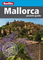
Mallorca Pocket Guide
Mallorca is a beautiful island. Long sandy beaches and isolated rocky coves are framed by sapphire seas and backed by dramatic mountain peaks, while olive groves and vineyards are found in the interior. The largest of Spain`s Balearic Islands, Mallorca also offers a wealth of attractions, ranging from watersports to wine-tasting.Berlitz Pocket Guide Mallorca is a concise, full-colour travel guide that gives you reliable, user-friendly information on the island, alongside vivid photography.Berlitz Mallorca Pocket Guide:- Where To Go details all the key sights on the island, from the lovely town of Deia to inland Valldemossa, while handy maps on the cover flaps help you find your way around, and are cross-referenced to the text.- Top 10 Attractions gives a run-down of the best
sights to take in on your trip, including the Coves del Drac, Sineu Market and Fundacío Pilar i Joan Miró.- Perfect Day provides an itinerary for one day on the island.- What To Do is a snapshot of ways to spend your spare time, including arts, shopping, and the best tapas.- Essential information on Mallorca`s culture, including a brief history of the island.- Eating Out covers the island`s best cuisine.- Curated listings of the best hotels and restaurants.- A-Z of all the practical information you`ll need.
sights to take in on your trip, including the Coves del Drac, Sineu Market and Fundacío Pilar i Joan Miró.- Perfect Day provides an itinerary for one day on the island.- What To Do is a snapshot of ways to spend your spare time, including arts, shopping, and the best tapas.- Essential information on Mallorca`s culture, including a brief history of the island.- Eating Out covers the island`s best cuisine.- Curated listings of the best hotels and restaurants.- A-Z of all the practical information you`ll need.

Product Description
Reviews/Comments
Add New
Vouchers
No voucher codes found.
Do you know a voucher code for this product or supplier? Add it to Insights for others to use.
Do you know a voucher code for this product or supplier? Add it to Insights for others to use.
 Denmark