
 United Kingdom
 France
 Germany
 Netherlands
 Sweden
 USA
USA
 Italy
Italy
 Spain
Spain
More From Contributor


Mallorca F&B
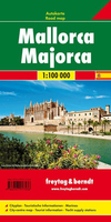
Majorca at 1:50, 000 on a large, double-sided, contoured map from Freytag & Berndt, with highlighting for scenic roads and tourist routes, plus a booklet with a GPS-annotated index, street plan of central Palma, and multilingual descriptions of the island’s best sights.Topography is shown by contours at 100m intervals, with numerous spot height, relief shading and boundaries of protected areas. Road network includes local tracks, indicates location of motorway services, and shows driving distances on main routes, toll roads, steep gradients, and roads closed to motorized traffic. Scenic roads and special tourist routes are highlighted. Railway lines are shown with stations and the map indicates car ferry connections. The map also shows long-distance GR hiking trails.
Locations worth visiting are highlighted, indicating which sites have descriptions in the accompanying booklet, and wide range of icons mark other places of interest. The map has a 10km UTM grid, plus latitude and longitude crosshairs at 5’ intervals.The accompanying 70-page booklet attached to the map cover includes an index with all the locations annotated with their GPS coordinates, a street plan of the historic heart of Palma de Mallorca, plus multilingual descriptions of Mallorca’s best sights. Map legend and all the text include English.PLEASE NOTE: the same mapping is also used in the publishers’ 2-map set, covering Mallorca on two more-handy size double-sided maps which additionally highlight recommended cycling and mountain bike routes. The set comes with a booklet
which, in addition to the features described above, also provides descriptions of the GR221 hiking trail, 10 cycling routes, plus four mountain biking circuits.

Product Description
Reviews/Comments
Add New
Vouchers
No voucher codes found.
Do you know a voucher code for this product or supplier? Add it to Insights for others to use.
Do you know a voucher code for this product or supplier? Add it to Insights for others to use.
 Denmark