More From Contributor
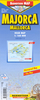
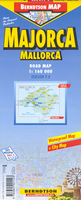
£15.99
This is the latest addition to the Major & Mrs Holt's Battlefield Guide series, & the first to concentrate on World War Two. Since Saving Private Ryan was filmed, interest in the D-Day landings has never been greater on both sides of the Atlantic. No one knows the Normandy Campaign & countryside as it stands today better than Major & Mrs Holt, the pioneers of battlefield touring.NEW, FULLY UPDATED EDITIONPACKAGED WITH A FREE, FULL COLOUR FOLD-OUT MAP ...
Archived Product
£16.99
Arranged around four itineraries this is the definitive guide to the battlefields of the Somme. Each itinerary takes in war memorials, cemeteries & battle sites. History & anecdote are mixed with directions, photographs & maps. Two suggested approaches to the Somme area are detailed. Background information on war graves organisations & Picardy in general is included. The Guide is supplied with a fold out map showing the front lines, ground held & divisional & corps boundaries. Symbols show the locations of various Memorials, cemeteries, museums, craters, preserved trenches, bunkers, etc. ...
Archived Product
£16.99
The 100th Anniversary of the most publically aware battle of WW1
- the battle of the Somme, will be on 1 July 2016 & every media
...
Archived Product
£16.99
Operation Market Garden was the name given to the US, UK & Polish airborne assault on the Arnhem, Nijmegen & Eindhoven bridges & the ill-fated 30 Corps advance to relieve the hard-pressed paras. While everyone knows that Arnhem was `a bridge too far`, few understand the true reasons for the catastrophic failure to link up. There have been numerous guide books to the fighting around Arnhem in particular but this is the first to tell the whole story as it happened. As the many thousands of satisfied Holt`s Guide readers know, the authors have an uncanny knack of getting to the nub of the story, explaining the action clearly & directing the visitor to the key sites in order that he/she gets the most from any visit. With its full colour touring map The Holt`s Battlefield Guide to Market Garden will prove as big a success as its forerunners, on both sides of the Atlantic & the Channel. ...
Archived Product
£8.99
Major Ernest Pettigrew is perfectly content to lead a quiet life in the sleepy village of Edgecombe St Mary, away from the meddling of the locals & his overbearing son. But when his brother dies, the Major finds himself seeking companionship with the village shopkeeper, Mrs Ali. Drawn together by a love of books & the loss of their partners, they are soon forced to contend with irate relatives & gossiping villagers. The perfect gentleman, but the most unlikely hero, the Major must ask himself what matters most: family obligation, tradition or love? Funny, comforting & heart-warming, Major Pettigrew`s Last Stand proves that sometimes, against all odds, life does give you a second chance. ...
Archived Product
£9.95
Majorca at 1:75, 000 on a large, double-sided contoured map from Kompass with a selection of hiking & cycling routes & extensive overprint highlighting various places of interest, plus a street plan of central Palma de Mallorca. Contours at 100-m intervals, spot-height, hill shading & colouring to indicate wooded areas & vineyards provide an excellent representation of the terrain. Road network

Includes::
farm roads & forest tracts & indicates toll routes & traffic restrictions. Railways are shown with stations & ferry connections between locations on the island are marked. An overprint highlights waymarked hiking routes, indicating steep & climbing sections. Also shown are cycle paths & mountain bike routes. A wide range of symbols highlight numerous places of interest, sport & recreational facilities, landmarks, protected areas, beaches, campsites & youth hostels, etc. The map has a UTM grid. Map legend

Includes::
English. Also provided is street plan of Palma, indicating main places of interest, plus a map showing ferry links from the mainland to the Balearic Islands. The map is part of Kompass


...
Archived Product
£9.99
Majorca & Palma de Mallorca on a clear & informative, waterproof & tear-resistant map from Berndtson, with both the road map & the street plan indexed & highlighting the island’s 15 top rated sites & other places of interest, as well as providing general tourist information. On one side a map of the island shows its road network, including selected cart tracks & footpaths, indicating locations of petrol stations. Road numbering reflects the change to the local system of “ Ma” numbers. Scenic routes are highlighted. A wide range of symbols mark various places of interest, including beaches, campsites, viewpoints, windmills, sport & recreational facilities, etc. 15 of the island’s main sights are marked, with a separate panel providing brief descriptions. Topography is shown by subtle relief shading. The index has a separate list of places of interest & beaches. The map has no geographical coordinates. On the reverse is a street plan of Palma de Mallorca at 1:7, 000, covering the city’s historic centre & the adjoining districts. One way streets, car parks, places of interest & selected hotels are highlighted. Street index

Includes::
lists of sights, consulates, parks, etc. Also included is a diagram of the metro line. The map also provides panels with climate details month by month & other useful tourist information. The map is printed on light, waterproof & tear-resistant plastic paper. Map legend

Includes::
English. All descriptions & notes are in English only.


...
Archived Product
£4.99
Majorca in a series of handy holiday pocket maps from Freytag & Berndt covering popular islands & other seaside destinations in Europe. Each map is laminated, so waterproof & tear-resistant, & highlights the publishers’ recommendations of five best choices in five categories: adventure, culture, food, nature & sights. On one side is a road map with icons highlighting numerous places of interest, including campsites & youth hostels, sport & recreational facilities, marinas & beaches, architectural & historical sites, etc. The maps have no geographical coordinates. Most titles also include a small street plan of the central area in the main town. The map &, if appropriate, the street plan are annotated with colour-coded markers highlighting the publishers’ recommendations of five best choices in five categories: adventure, culture, food, nature & sights, all listed on the reverse of the map with brief notes in several languages. Also provided is a Fact Box with phone numbers for tourist offices, car hire & emergency services. Map legend & notes on the recommendations include English. To see other titles in this series please click on the series link. ...
Archived Product
£5.99
Majorca in the Everyman Map Guide series; comprising a range of practical guide books incorporating large scale maps to a number of international cities & regions. Including a unique binding method, each district, neighbourhood, area or region has an accompanying fold-out page with a large scale overview map which is fully indexed. Each Map Guide also has details of more than 100 shops, restaurants, bars, clubs, markets & other local attractions, in addition to more practical guidance, listed underneath & on the reverse of the fold-out map. All of the main attractions also have accompanying illustrations, & there are also transport maps & a street index to help visitors find their way around. ...
Archived Product
£18.95
Makalu Barun region in the Newgrove Consultants’ series covering the course of Great Himalaya Trail High Route at 1:100, 000 on nine maps printed on light, waterproof & tear-resistant plastic paper. The map is single-sided & covers the High Route across the Makalu Barun National Park between the easternmost part of the Sagarmatha National Park with the Pheriche Pass & Island Peak & the western edge of the Kanchenjunga Conservation Area. The base map, derived from satellite imagery, has contours at 200m intervals enhanced by relief shading & colouring to show glaciers, the snow line at 6000m, barren l&, forests, etc. Numerous spot heights are marked in the high-laying areas, but not very many & in places none on the south side of the trail. Important peaks & mountain passes are prominently marked. Boundaries of national parks & other protected areas are also shown. The High Route of the GHT is clearly highlighted & adjoining local routes are divided into main trails & footpaths. Icons indicate locations of campsites & hotels/lodges, health posts, stupas, gompas & mani walls both along the GHT itself & in other locations on the map. Settlements are graded into large towns, towns, villages & small villages. The maps have latitude & longitude lines at intervals of 5’. All information is in English. Seven of the maps are double-sided, with the last three maps covering the easternmost part of the country from Rolwaling Himal & Mt Everest to Kanchenjunga on single-sided maps. PEASE NOTE: Sheet No. 1, Far West, covers an area outside the course of the High Route. It shows the route of the Lower Great Himalaya Trail. According to the publishers’ notes: “ The maps have been created & published by Newgrove Consultants on behalf of The Great Himalaya Trail Development Programme which is funded by the UK Department for International Development & managed by SNV Netherland’s Development Organization. United Nations World Tourism Organization through its “ Sustainable Tourism – Eliminating Poverty” programme ahs played a key role in bringing the project into fruition. The maps are based on data from the National Geographic Information Infrastructure Programme (NGIIP) of Nepal. The International Centre for Integrated Mountain Development (ICIMOD) also provided low scale data. Trekkers & guides have been consulted on current routes.” ...
Archived Product

Majorca

Tourist road map of the island on laminated waterproof paper, showing many attractions and landmarks, with a clear street plan of Palma on the reverse. Road detail includes some minor roads, with intermediate driving distances indicated on many routes, and high passes and closed roads shown in the mountainous regions. PLEASE NOTE: current edition of this map, published in 2006, shows the old road numbers.A small inset extends the map coverage to include Isla Cabrera. General relief is portrayed by hill-shading with some additional spot heights marked for selected peaks. A range of symbol depicts many landmarks and tourist features eg. petrol stations, antiquities, windmills, beaches, viewpoints, caves and chapels. National parks and reserves are also marked.The street plan of
Palma de Mallorca at 1:7, 000 extends well beyond the old town centre and shows one-way streets, pedestrian zones, hotels, consulates, hospitals, car parks, public buildings, notable buildings and sites of interest. Both maps are indexed for place names, streets, districts and selected locations of interest and buildings, as appropriate to the scale and level of detail. A small panel presents some basic statistics and climate information and there is a small map showing Spain
RIP - This product is no longer available on our network. It was last seen on 25.09.2019

This page now acts as a permanent archive for this product. Add more information using the comments box below to ensure it can still be found by future generations.

Use our search facility to see if it is available from an alternative contributor.
  • External links may include paid for promotion
  • Availability: Out Of Stock
  • Supplier: Stanfords
  • SKU: 9783866093331
Availability: In Stock
£5.99

Product Description

Tourist road map of the island on laminated waterproof paper, showing many attractions & landmarks, with a clear street plan of Palma on the reverse. Road detail

Includes::
some minor roads, with intermediate driving distances indicated on many routes, & high passes & closed roads shown in the mountainous regions. PLEASE NOTE: current edition of this map, published in 2006, shows the old road numbers.A small inset extends the map coverage to include Isla Cabrera. General relief is portrayed by hill-shading with some additional spot heights marked for selected peaks. A range of symbol depicts many landmarks & tourist features eg. petrol stations, antiquities, windmills, beaches, viewpoints, caves & chapels. National parks & reserves are also marked. The street plan of Palma de Mallorca at 1:7, 000 extends well beyond the old town centre & shows one-way streets, pedestrian zones, hotels, consulates, hospitals, car parks, public buildings, notable buildings & sites of interest. Both maps are indexed for place names, streets, districts & selected locations of interest & buildings, as appropriate to the scale & level of detail. A small panel presents some basic statistics & climate information & there is a small map showing Spain

Reviews/Comments

Add New

Price History

Vouchers

No voucher codes found.
Do you know a voucher code for this product or supplier? Add it to Insights for others to use.

Facebook

Jargon Buster

Paper - A thin sheet mainly used for writing. Available in a variety of colours. Made mainly from wood pulp.
Spain - A country within the EU.
Waterproof - Resistant to water, usualy specified by depth in metres
Car - A machine used for transport which runs on roads
Small - something that takes up less space than normal.
Road - a manmade lane or a path that is used to speed up travel.
Laminated - A thin layer of plastic that gives a coating and shine to a material.

Supplier Information

Stanfords
Stanfords was established in 1853 and opened their iconic Covent Garden flagship store in 1901. They have become the top retailer of maps, travel books and accessories in the UK and arguably offer the largest selection of maps and travel books worldwide. Famous names such as Captain Robert Falcon Scott, Ranulph Fiennes and Michael Palin have purchased from Stanfords. They now have a shop in Bristol and both stores together with other venues operate a calendar of events including talks, book signings and exhibitions. As a specialist map retailer, the map selection is comprehensive and includes road maps, street maps and walking maps from worldwide destinations, as well as a selection of world atlases and wall maps. Books include travel guides and travel literature. Stanfords also stock globes, from miniatures made of blue marble to magnificent floor-standing globes. The website features a selection of interesting articles on travel topics.
Page Updated: 2023-11-12 20:15:36

Community Generated Product Tags

Oh No! The productWIKI community hasn't generated any tags for this product yet!
Menu