
 United Kingdom
 France
 Germany
 Netherlands
 Sweden
 USA
USA
 Italy
Italy
 Spain
Spain
More From Contributor


Madeira F&B
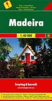
Madeira on a large, indexed, touring and sightseeing map from Freytag & Berndt at 1:40, 000 with prominent highlighting for scenic roads, hiking routes, picturesque locations and places of interest, plus a street plan of central Funchal and a booklet with descriptions of best sights, etc. Place names and road numbers are in larger size font than found on other maps of the island. Topography is presented by contours enhanced by relief shading, with numerous spot heights and names of geographical features. Boldly presented road network includes local roads or tracks, gives distances on main routes, and shows gradients on steep sections. Scenic routes are prominently marked. Hiking trails are also highlighted and where appropriate annotated with their official waymarking route
numbers. The map indicates picturesque towns and villages, with the islands’ best sights described in the accompanying booklet attached to the cover and clearly marked on the map itself by large icons. A wide range of other icons indicate various places of interest. A separate inset at the same scale as the main map shows Porto Santo with similar presentation. For GPS, the map has a UTM grid, plus latitude and longitude margin ticks at intervals of 2’. The booklet provides an index which also gives for each location its GPS waypoints. Also provided is a street plan showing main sights in Funchal. Map legend and the descriptions in the booklet include English.Please note: the same map is also published by Freytag & Berndt enlarged to 1:30, 000 and presented on smaller size,
double-sided sheet. Accompanying booklet includes descriptions of seven hiking routes.

Product Description
Reviews/Comments
Add New
Vouchers
No voucher codes found.
Do you know a voucher code for this product or supplier? Add it to Insights for others to use.
Do you know a voucher code for this product or supplier? Add it to Insights for others to use.
 Denmark