More From Contributor
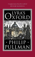
£20.50
Lyon à pied, FFRP topo-guide Ref. No. VI08, with six thematic walks within the city centre & across the suburbs, all marked on detailed street plans cross-referenced to the descriptions. Current edition of this title was published in November 2013.ABOUT THE FFRP (Fédération française de la randonée pédestre) TOPOGUIDES: published in a handy A5 paperback format, the guides are the best companions for hiking in France. In addition to their topo-guides to the long-distance GR routes FFRP also publish an extensive range of guides with local day walks. Each walk in presented on a colour extract from IGN`s 1:50, 000 or 1:25, 000 topographic survey mapping overprinted with the route, with important points cross-referenced to the accompanying text, in French only, placed on the adjoining page. For each walk the guides also indicate the degree of difficulty & provide information on length, time & change in altitude, waymarking signs, access by road & parking facilities. An “info practiques” section of the guide indicates where shops, restaurants & accommodation can be found. The guides are published on high quality paper & include descriptions of the most interesting aspects of the surrounding region: historical & cultural sites, local specialties, fauna & flora, etc, all illustrated with colour photos. ...
Archived Product
£6.99
This is the savvy city breakers' pocket guide to seeing & doing more in Lyon
- France's gastronomic centre
- with a fun-seeking

...
Archived Product
£8.99
Detail regional road map of Lyon & its surrounding area at 1:50, 000, with coverage extending north to south from Trevoux to Vienne, & east to west from Mountains of Lyon to Bourgoin-Jallieu. Detailed mapping of regional & minor local roads is combined with very clear presentation of motorways & main national routes. The map indicates road width & the number of lanes, access restrictions, unmaintained sections of minor local roads, etc. Sections in construction, both on main routes & local roads are displayed. The map also shows the railway network with stations. Topography is shown with relief shading & contour lines & intervals of 20metres, basic terrain variations denoted by simple use of colours. A wide range of symbols highlight numerous places of interest & local facilities. Map legend

Includes::
English.

...
Archived Product
£6.95
Lyon in the Wallpaper* City Guide series, published by Phaidon & encompassing a collection of pocket-size guides dedicated to the best design elements in major cities. Compiled by experts at the Wallpaper* magazine, the guides are widely recognized for appealing to design-conscious travellers & are aimed at those interested in art, design & architecture. Each guide identifies the best bars, restaurants, hotels, places to shop, leisure activities & excursions with a unique emphasis on the finest examples of unusual architecture & design. Each Wallpaper* City Guide has the same layout, with separate tabs allowing readers & travellers to access individual sections easily. The tabs consist of Landmarks, Hotels, 24 Hours, Urban Life, Architour, Shopping, Sports & Escapes. High quality colour photographs appear alongside brief descriptions of each hotel, bar or attraction, highlighting distinctive & unusual styles of architecture & design. Extra pages are provided at the back of each guide, allowing readers to record their own notes & sketches. ...
Archived Product
£6.50
Lyon & its Environs in a series of detailed road maps at 1:80, 000 from the IGN, designed to highlight places of interest & recreational possibilities, with a city centre street plan & an enlargement of a selected hiking in area. Cartography is an enlargement from 1:100, 000 to 1:80, 000 of the publisher ...
Archived Product
£12.99
Set in 1950s Sudan, Lyrics Alley is the story of the powerful & sprawling Abuzied dynasty. With Mahmood Bey at its helm, the family can do no wrong. But when Mahmood's son, Nur
- the brilliant, charming heir to his business empire
- suffers a near-fatal accident, his hopes of university & a glittering future are dashed. Subsequently, his betrothal to his cousin & sweetheart, Soraya is broken off, another tragedy that he is almost unable to bear. As British rule is coming to an end, & the country is torn between modernising influences & the call of traditions past, the family is divided. Mahmood's second wife, Nabilah, longs to return to Egypt & leave behind her the dust of 'backward-looking' Sudan. His first wife, Waheeba, lives traditionally behind veils & closed doors & resents Nabilah's influence on Mahmood. Meanwhile, Nur must find a way to live again in the world & find peace. Moving from the villages of Sudan to cosmopolitan Cairo & a decimated post-colonial Britain, this is a sweeping tale of loss, faith & reconciliation.

...
Archived Product
£22.95
Map No. 10009, Lysebotn, in the new topographic survey of Norway at 1:50, 000 covering the country on 195 double-sided sheets & first published by Nordeca in 2011
- 2012; fully GPS compatible, indicating waymarked footpaths, campsites, tourist huts, illuminated ski runs, etc. The maps, now published by Nordeca, the successors to Statens Kartverk & its subsequent owners the Ugland Group, are printed on light, waterproof & tear-resistant synthetic paper. Each map covers an area of 62x 45 kilometres (39 x 28 miles approx.), with a 2-km overlap between the sheets. The maps have contours at 20m intervals (10m glacier contours), plus colouring & graphics to show cultivated areas, bogs, forests, etc. In addition to all the information expected of topographic mapping at this scale the maps distinguish between waymarked & unmarked footpaths & show campsites, tourist huts (serviced/self service/no supplies), country hotels & restaurants, & illuminated ski trails. The series uses EUREF89 (WGS84) datum & the maps have a 1-km UTM grid. Map legend is in Norwegian & English. Each title comes in a sturdy protective card envelope.
...
Archived Product
£23.99
Lysefjorden area in Norway in a series of GPS compatible recreational maps at 1:50, 000 with cartography from Norway’s topographic survey & additional tourist information. Contours lines are drawn at 20m intervals. The overprint varies from title to title, but

Includes::
local footpaths, in some cases distinguishing between easy & more difficult trails, as well as mountain huts & campsites. Many titles also indicate cycle or ski routes, other accommodation possibilities, sport & recreational facilities, including alpine skiing slopes, places of interest, etc. The maps have a UTM grid & margin ticks giving latitude & longitude. Map legend

Includes::
English. Several titles have on the reverse additional tourist information, although in most cases in Norwegian only. To see the list of Turkart maps at 1:50, 000 & links to Turkart series at 25K, 100K & Hiking Sets please click on the series link above.


...
Archived Product
£25.99
Topo 3000 Lysefjorden by Nordeca is a detailed map covering an area of 64 x 47 km (over 3000 km 2). Here you will find the hiking routes easily, over the mountains, through the forest & along the roads. Lodgings are clearly marked to facilitate your planning. ...
Archived Product
£16.99
Topographic survey of Sweden at 1:50, 000, the Terrängkartan, from the Lantmäteriet, covering most of the country in 244 double-sided maps. Please note: the mountainous regions of central & northern Sweden are not covered by this series but presented in a separate “ Fjällkartan
- Mountain Map” series also listed on our website. Each 1:50, 000 topographic survey map covers an area of 37.5 x 40km. The maps have contours at 5 metre intervals, plus relief shading & graphics for rocky outcrops & boulders. Further graphics and/or colouring show different types of land use or vegetation (forests, arable l&, orchards, marshes, peat bogs, etc). An unusual feature of this survey is the colouring indicating buildings below or above two storeys high & “leisure/holiday homes”. The maps indicate privately maintained roads & include all other information expected of topographic survey at this scale. The maps have a 1-km UTM grid, plus latitude & longitude lines 5’ intervals. Map legend

Includes::
English. For coverage of the country’s most visited hiking areas in central & northern Sweden please see Lantmäteriet’s Mountain Map series, listed separately on our website.


...
Archived Product

Lyra`s Oxford

This is a wonderful new episode from the world of Philip Pullman`s bestselling trilogy, His Dark Materials. In Lyra`s Oxford the reader shares the huge excitement of discovering a small bundle of material that has somehow slipped between Lyra`s universe and our own. The book includes a wonderful new story by Philip Pullman, fully illustrated intricate maps and other ephemera from Lyra`s universe.The text is illustrated throughout in beautiful black and white wood-blocks by the highly acclaimed engraver, John Lawrence, together with specially printed three-colour pull out maps of Lyra`s Oxford. This publication could have come from a parallel universe. The short story contained within Lyra`s Oxford finds Lyra with her daemon Pantalaimon a couple of years after the end of The Amber
Spyglass.Sitting on the roofs of Oxford she sees a bird, the daemon of a witch, a storm petrel flying towards her pursued by a huge and angry flock of starlings. Birds play a big part in this story. And gradually a mystery unfolds...
RIP - This product is no longer available on our network. It was last seen on 25.09.2019

This page now acts as a permanent archive for this product. Add more information using the comments box below to ensure it can still be found by future generations.

Use our search facility to see if it is available from an alternative contributor.
  • External links may include paid for promotion
  • Availability: Out Of Stock
  • Supplier: Stanfords
  • SKU: 9780857535573
Availability: In Stock
£7.99

Product Description

This is a wonderful new episode from the world of Philip Pullman`s bestselling trilogy, His Dark Materials. In Lyra`s Oxford the reader shares the huge excitement of discovering a small bundle of material that has somehow slipped between Lyra`s universe & our own. The book

Includes::
a wonderful new story by Philip Pullman, fully illustrated intricate maps & other ephemera from Lyra`s universe. The text is illustrated throughout in beautiful black & white wood-blocks by the highly acclaimed engraver, John Lawrence, together with specially printed three-colour pull out maps of Lyra`s Oxford. This publication could have come from a parallel universe. The short story contained within Lyra`s Oxford finds Lyra with her daemon Pantalaimon a couple of years after the end of The Amber Spyglass. Sitting on the roofs of Oxford she sees a bird, the daemon of a witch, a storm petrel flying towards her pursued by a huge & angry flock of starlings. Birds play a big part in this story. & gradually a mystery unfolds...

Reviews/Comments

Add New

Intelligent Comparison

Oooops!
We couldn't find anything!
Perhaps this product's unique.... Or perhaps we are still looking for comparisons!
Click to bump this page and we'll hurry up.

Price History

Vouchers

No voucher codes found.
Do you know a voucher code for this product or supplier? Add it to Insights for others to use.

Facebook

Jargon Buster

Black - A colour which does not emit any colour of the spectrum. Black absorbs all frequencies of the spectrum.
Amber - Fosilised tree resin appreciated for its colour
Amber - A yellowy orange colour
White - A colour combining all colours
Dark - A colour which absorbs visable ligt so apears less light than objects that reflect light
World - A physical grouping, commonly used to describe earth and everything associated with ti
Wood - A hard material found in trees. Used for tool making, fuel and construction.
Colour - The categorised spectrum of light visable to humans
Small - something that takes up less space than normal.
Parallel - Two objects that run symmetrically alongside each other.
Universe - Every matter and space, thought to be around 10 billion years old.
Wonderful - Another word for describing something that is extremely good, marvellous.

Supplier Information

Stanfords
Stanfords was established in 1853 and opened their iconic Covent Garden flagship store in 1901. They have become the top retailer of maps, travel books and accessories in the UK and arguably offer the largest selection of maps and travel books worldwide. Famous names such as Captain Robert Falcon Scott, Ranulph Fiennes and Michael Palin have purchased from Stanfords. They now have a shop in Bristol and both stores together with other venues operate a calendar of events including talks, book signings and exhibitions. As a specialist map retailer, the map selection is comprehensive and includes road maps, street maps and walking maps from worldwide destinations, as well as a selection of world atlases and wall maps. Books include travel guides and travel literature. Stanfords also stock globes, from miniatures made of blue marble to magnificent floor-standing globes. The website features a selection of interesting articles on travel topics.
Page Updated: 2023-11-12 20:15:36

Community Generated Product Tags

Oh No! The productWIKI community hasn't generated any tags for this product yet!
Menu