
 United Kingdom
 France
 Germany
 Netherlands
 Sweden
 USA
USA
 Italy
Italy
 Spain
Spain
More From Contributor


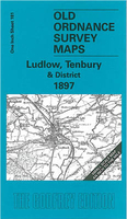
Ludlow, Tembury And Dirtrict 1897
Ludlow, Tembury and District 1897 in a series of reproductions of Ordnance Survey’s famous ”Inch to the Mile” maps published in the Alan Godfrey Editions to provide a historical record of England and Wales in the second half of 19th and early 20th century.In this title coverage stretches from Leintwardine eastward to Tenbury Wells, and from Bromfield southward to the outskirts of Leominster. Other locations include: in HEREFORDSHIRE Adforton, Aston, Aymestrey, Burrington, Collington, Downton on the Rock, Elton, Eye, Eyton, Hatfield, Kimbolton, Kingsland, Leinthall Starkes, Little Hereford, Lucton, Middleton on the Hill, Orleton, Pudleston, Richards Castle, Rochford, Shobdon, Thornbury, Wigmore and Yarpole; in SHROPSHIRE Ashford Bowdler, Ashford Carbonell,
Bitterley, Boraston, Burford, Caynham, Corley, Greet, Hope Baggot, Hopton Waters, Milson, Neen Sollars and Whitton; plus in WORCESTERSHIRE Hanley Child and Stoke Bliss. On the reverse is a detailed map of Woofferton Junction including part of Brimfield.About the Alan Godfrey Editions of the OS Inch to the Mile Maps: the maps provide an invaluable overview of a wider area, typically 18 x 12 miles (29 x 19 kms approx.), and offer historical mapping for small towns and villages not covered by the more detailed series for which the Godfrey Editions are better known. On the reverse all the maps have historical notes and most titles also include a more detailed, large scale map of a small town or a village in the area.To see other titles in this series please click on the series
link.

Product Description
Reviews/Comments
Add New
Vouchers
No voucher codes found.
Do you know a voucher code for this product or supplier? Add it to Insights for others to use.
Do you know a voucher code for this product or supplier? Add it to Insights for others to use.
 Denmark