More From Contributor
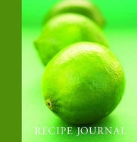
£14.99
This handy ANWB map full of great cycling routes, spread across the province & neighboring regions. Each guide contains 14 separate routes, printed on a card in A4 format. The route map contains clear route descriptions, sights, current cycling junctions long-distance routes, street names & all ANWB Hospitable Points. There is also a sheet with ANWB Node Cards & a brochure with the user manual & tips for each route map. With a scale of 1: 100, 000 (1 cm = 1 km) the cards are very readable. The ANWB Fietsgids is available in a series of 11 parts, in which all provinces are described in detail. ...
Archived Product
£11.50
Limburg North: Eindhoven
- Roermond area in a series of cycling maps from Sportoena covering Belgium & the adjoining regions of
...
Archived Product
£15.25
The eastern part of the Limburg province, along the Meuse, in a series of cycling maps of selected areas of Belgium with each title presented as box containing eight separate, waterproof & tear-resistant maps, each showing a day route. All the text is in Dutch only. Each title is a set of eight, handy size (30x 42cm) maps printed on waterproof & tear-resistant plastic. On one side is a detailed map with the route clearly overprinted on the local road network. The maps are not contoured & have no GPS coordinates; topographic information is limited to rivers & other waterways, plus colouring for woodlands & built-up areas. On the reverse the whole route is shown as a list of directional instructions. Also provided are a list of cycle-friendly local caf ...
Archived Product
£15.25
The northern part of the Limburg province in a series of cycling maps of selected areas of Belgium with each title presented as box containing eight separate, waterproof & tear-resistant maps, each showing a day route. All the text is in Dutch only. Each title is a set of eight, handy size (30x 42cm) maps printed on waterproof & tear-resistant plastic. On one side is a detailed map with the route clearly overprinted on the local road network. The maps are not contoured & have no GPS coordinates; topographic information is limited to rivers & other waterways, plus colouring for woodlands & built-up areas. On the reverse the whole route is shown as a list of directional instructions. Also provided are a list of cycle-friendly local caf ...
Archived Product
£11.50
Limburg South: Hasselt
- Maastricht area in a series of cycling maps from Sportoena covering Belgium & the adjoining regions of
...
Archived Product
£7.50
Limerick on an indexed street plan at 1:13, 000 from the Ordnance Survey of Irel&. An enlargement shows the city centre in greater detail, highlighting 28 places of interest and/or facilities. The index is in a separate booklet attached to the map cover. The index is in a separate booklet attached on the map cover.OSI street plans highlight main traffic arteries in each town: national primary & secondary routes, regional roads & main streets, with one way & pedestrianized streets. Colouring indicates public buildings, highlighting the more important ones, railway/bus stations & medical centres. A range of symbols indicate various facilities, including An ...
Archived Product
£8.25
Map No. 65, Limerick North-East in the Discovery series from the OSI, the Ordnance Survey of Irel&, which presents the country on detailed topographic maps at 1:50, 000, with additional overprint highlighting campsites & caravan parks, youth hostels, etc. The maps have contours at 10m intervals, with plenty of spot heights & additional altitude colouring. Graphics indicate different types of woodlands. An overprint highlights waymarked or unmarked walking trails as well as cycle routes. National or forest parks & nature reserves are marked & a range of symbols provide tourist information: campsites, caravan parks, youth hostels (An ...
Archived Product
£8.25
Map No. 64, Limerick North-West in the Discovery series from the OSI, the Ordnance Survey of Irel&, which presents the country on detailed topographic maps at 1:50, 000, with additional overprint highlighting campsites & caravan parks, youth hostels, etc. The maps have contours at 10m intervals, with plenty of spot heights & additional altitude colouring. Graphics indicate different types of woodlands. An overprint highlights waymarked or unmarked walking trails as well as cycle routes. National or forest parks & nature reserves are marked & a range of symbols provide tourist information: campsites, caravan parks, youth hostels (An ...
Archived Product
£7.50
Limerick on an indexed street plan at 1:13, 000 from the Ordnance Survey of Irel&, with an enlargement showing the city centre in greater detail plus reproductions of historical mapping from 1840 & 1870. OSI street plans highlight main traffic arteries in each town: national primary & secondary routes, regional roads & main streets, with one way & pedestrianized streets. Colouring indicates public buildings, highlighting the more important ones, railway/bus stations & medical centres. A range of symbols indicate various facilities, including An Óige or independent hostels, tourist offices, museums & galleries, shopping centres, sport grounds, etc. The city centre enlargement highlights 28 places of interest and/or facilities. The index is on the reverse where this 5th edition of this title also

Includes::
reproductions of an Ordnance Survey map of Limerick from 1840 & a plan of the King John’s Castle surveyed in 1870.

...
Archived Product
£11.99
Topographical survey of Belgium at 1:50, 000 from the country’s national survey organization, Nationaal Geografisch Instituut / Institut Géographique National. Contour interval varies according to the terrain, from 2.5 metres in the coastal areas to 10 metres in the Ardennes. The maps provide all the information expected of topographic mapping at this scale & in addition have an unusually large amount of vegetation and/or land use information (different types of woodlands, gardens, orchards, heath, etc). Each standard sheet covers Approx. 32 x 20 km / 20 x 12 miles, with larger maps published for the border or coastal areas. The maps have a 1-km UTM grid, with margin ticks for latitude & longitude at intervals of 1`. Map legend & a glossary of terms used on the maps include English.PLEASE NOTE: the Long-Distance Footpaths Map of Belgium at 1:300, 000 is overprinted with the grid for the 1:50, 000 topographic survey, showing the exact coverage of each sheet. Stanfords keeps as regular stock 50K maps for the World War I battlefields around the Ypres, Messines & Passchendaele, & for the area of the Battle of Waterloo. Maps for other regions can be supplied as special orders – to see the list of all the titles in this series please click on the series link. ...
Archived Product

Lime Recipe Journal

Always wondering where to write down those favourite recipes that you collect from friends, family, magazines etc. Featuring a cloth bound spine this beautifully packaged journal is the answer. This recipe journal has six section dividers for easy access - Soups & Starters, Seafood, Meat & Poultry, Pasta & Rice, Vegetables & Salads and Sweet Treats. An added bonus is the pocket at the back to store your recipes when you haven`t time to write them out.
RIP - This product is no longer available on our network. It was last seen on 25.09.2019

This page now acts as a permanent archive for this product. Add more information using the comments box below to ensure it can still be found by future generations.

Use our search facility to see if it is available from an alternative contributor.
  • External links may include paid for promotion
  • Availability: Out Of Stock
  • Supplier: Stanfords
  • SKU: 9781741108552
Availability: In Stock
£9.99

Product Description

Always wondering where to write down those favourite recipes that you collect from friends, family, magazines etc. Featuring a cloth bound spine this beautifully packaged journal is the answer. This recipe journal has six section dividers for easy access
- Soups & Starters, Seafood, Meat & Poultry, Pasta & Rice, Vegetables & Salads & Sweet Treats. An added bonus is the pocket at the back to store your recipes when you haven`t time to write them out.

Reviews/Comments

Add New

Intelligent Comparison

Oooops!
We couldn't find anything!
Perhaps this product's unique.... Or perhaps we are still looking for comparisons!
Click to bump this page and we'll hurry up.

Price History

Vouchers

No voucher codes found.
Do you know a voucher code for this product or supplier? Add it to Insights for others to use.

Facebook

Jargon Buster

Lime - A greenish yellow sour citrus fruit
Lime - A yellowy green colour
Friends - A close associate or a popular US based sitcom about a group of friends
Pocket - A bag shaped insert in clothing used to carry items
Family - A group of people that live together made up from parents and children.

Supplier Information

Stanfords
Stanfords was established in 1853 and opened their iconic Covent Garden flagship store in 1901. They have become the top retailer of maps, travel books and accessories in the UK and arguably offer the largest selection of maps and travel books worldwide. Famous names such as Captain Robert Falcon Scott, Ranulph Fiennes and Michael Palin have purchased from Stanfords. They now have a shop in Bristol and both stores together with other venues operate a calendar of events including talks, book signings and exhibitions. As a specialist map retailer, the map selection is comprehensive and includes road maps, street maps and walking maps from worldwide destinations, as well as a selection of world atlases and wall maps. Books include travel guides and travel literature. Stanfords also stock globes, from miniatures made of blue marble to magnificent floor-standing globes. The website features a selection of interesting articles on travel topics.
Page Updated: 2023-11-12 20:15:36

Community Generated Product Tags

Oh No! The productWIKI community hasn't generated any tags for this product yet!
Menu