
 United Kingdom
 France
 Germany
 Netherlands
 Sweden
 USA
USA
 Italy
Italy
 Spain
Spain
More From Contributor


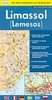

Limassol
Indexed street plan of Limassol from Selas, with a plan of the Eastern Limassol Beach holiday complex and a road map of the Limassol district. The street plan, with one way streets and locations of petrol stations, highlights tourist accommodation, public buildings and various facilities, which are listed in a separate index, cross-referenced to the plan. The main street index is on the reverse.Also included is a plan at 1:10, 500 of the Eastern Limassol Beach area, highlighting tourist accommodations and a road map of the Limassol district at 1:250, 000, showing places of interest, locations of petrol stations, villages with restaurants, etc. All place names are in Latin alphabet only.
Product Description
Reviews/Comments
Add New
Intelligent Comparison
Archived Product

Limassol Stanfords
£8.99
Vouchers
No voucher codes found.
Do you know a voucher code for this product or supplier? Add it to Insights for others to use.
Do you know a voucher code for this product or supplier? Add it to Insights for others to use.
 Denmark