
 United Kingdom
 France
 Germany
 Netherlands
 Sweden
 USA
USA
 Italy
Italy
 Spain
Spain
More From Contributor


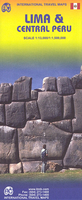
Lima & Central Peru ITMB
Central Lima at 1:13.000 on a clear, indexed street plan from ITMB plus, on the reverse a road map of central Peru at 1:1, 500, 000 with coverage of the country’s most visited sites including Cuzco and Machu Picchu, Cordillera Blanca and Huayhuash, Nazca, etc.On once side is an indexed street plan of central Lima, including its historic town centre. Public transport stations are clearly marked and main traffic arteries are highlighted. The plan also shows various public buildings and services, places of interest, etc. Also provided are a road map of the city’s environs and a diagram of the railway/BRT network.On the reverse is a road map of central Peru, with coverage including Cordillera Blanca and Huayhuash and extending north beyond Trujillo and Cajamarca, plus south
beyond Nazca. Altitude colouring with spot heights, plus graphics for active volcanoes and swamps, etc. shows the topography. Places of interest including World Heritage sites such as Machu Picchu or the Nazca Lines, Inca sites, beaches and bird watching areas, etc. are highlighted. The map has latitude and longitude lines at intervals of 1° and is indexed.
beyond Nazca. Altitude colouring with spot heights, plus graphics for active volcanoes and swamps, etc. shows the topography. Places of interest including World Heritage sites such as Machu Picchu or the Nazca Lines, Inca sites, beaches and bird watching areas, etc. are highlighted. The map has latitude and longitude lines at intervals of 1° and is indexed.

Product Description
Reviews/Comments
Add New
Vouchers
No voucher codes found.
Do you know a voucher code for this product or supplier? Add it to Insights for others to use.
Do you know a voucher code for this product or supplier? Add it to Insights for others to use.
 Denmark