More From Contributor

£8.25
Map No. 74, Tipperary South in the Discovery series from the OSI, the Ordnance Survey of Irel&, which presents the country on detailed topographic maps at 1:50, 000, with additional overprint highlighting campsites & caravan parks, youth hostels, etc. Current 4th edition of this map was published in January 2013. Maps in the Discovery series have contours at 10m intervals, with plenty of spot heights & additional altitude colouring. Graphics indicate different types of woodlands. An overprint highlights waymarked or unmarked walking trails as well as cycle routes. National or forest parks & nature reserves are marked & a range of symbols provide tourist information: campsites, caravan parks, youth hostels (An Óige & independent), tourist offices, parking & picnic places, & viewpoints. Golf courses indicate the number of holes. The maps also highlight antiquities & historical sites such as megalithic tombs, standing stones, battlefields, etc. Road network grades third class roads according to their widths &

Includes::
local tracks. Railways are shown with stations & the maps include other details expected of topographic mapping at this scale. Where appropriate, place names are given in both Irish & English. Each map covers an area of 40 x 30km (25 x 19 miles approximately) & has a 1km ITM (Irish Transverse Mercator) grid, plus latitude & longitude margin ticks at 1` intervals. Map legend is in Irish & English. To see the list of all the titles in this series please click on the series link.

...
Archived Product
£9.50
The waterproof Footprint map-guide to the Cumbria Way
- the 73 mile (117km) route between Ulverstone & Carlisle. It generally follows
...
Archived Product
£9.99
D-Day: Tales from the Front Line is the gripping account of the build-up to & aftermath of the single most decisive battle of the Second World War, as told by participants ranging from generals to frontline soldiers, statesmen & civilians. Compelling first-hand accounts in the form of interviews, letters & diaries, make this a superlative “living history” of a seminal day, & a homage to the bravery & skill of the extraordinary participants – most of them no more than high school age boys – who through their actions shaped modern history, many at the forfeit of their lives. D-day took place almost exactly four years after the date of Churchill’s famous “ We shall fight them on the beaches” speech, & has, as Bastable points out, to this day maintained its ‘mythic resonance’ in the catalogue of military victories: “ For the peoples of the many nations who took part – not just Britons & Americans & Canadians, but Frenchmen, Belgians, Poles, Norwegians, Dutchmen, Danes & some free Germans – D-Day says something meaningful about who they are as a nation, & about what they are capable of at their best.” It is this singular status in modern history that this book pays testament to. A victory which took place in the teeth of the worst storm in thirty years raging across the south of England & which saw nearly 3000 men killed on the three-mile strip of Omaha Beach alone. Bastable’s narrative is chock full of poignant human interest as well as fascinating historical details, such as the M15 visit to a bemused physics teacher who compiled the Daily Telegraph crossword in his spare time, only to be told that he had been inadvertently drawing public attention to highly sensitive military code words, or the fact that Churchill & King George VI initially planned to watch the invasion from a cruiser squadron (much to Eisenhower’s disapproval), before the King had second thoughts & managed to persuade Churchill only after a couple of personal, pleading letters: “I am a younger man than you, I am a sailor, & as King I am the head of all these Services. There is nothing I would like better than to go to sea, but I have agreed to stay at home; is it fair that you should then do exactly what I should have liked to do myself? You said yesterday afternoon that it would be a fine thing for the King to lead his troops into battle, as in the old days; if the King cannot do this, it does not seem to me right that his Prime Minister should take his place.” The book vividly brings to life its cast of modern historical heroes, men as flawed & as great as their classical forebears & certainly as, if not more, eccentric. One such was Lord Lovat who would ‘walk calmly with his head held high while all the rest of us would be ducking & diving to avoid shells’, commanding his personal piper to play Highland Laddie as they stepped off the ramp (“ Whenever I hear that song I remember walking through the surf”, Bill Mullin the piper remarked in later years). Yet another was General Hobart, who Churchill had brought out of obscure demotion to design what became known as “ Hobart’s funnies” – decidedly odd-looking but astonishingly innovative & effective new tanks, such as a the Duplex Drive, which looked “like a strange dinghy” but could function on both land & water, & the Crab, which crawled slowly along flogging the ground with chains on either side, thus setting off any mines in its path. (The Americans, perturbed by the appearance of these innovations, widely disdained their use, & suffered higher casualties as a result.) & lest the British claim all the eccentricity for themselves, what about Theodore Roosevelt, son of the former President & distant cousin of the serving one, who insisted on being present despite having suffered a heart attack & walking with a stick, & refused to wear a helmet because he thought they were uncomfortable? But Bastable’s book gives equal weight, equal value, to the experiences of the ordinary, non-decorated soldiers for, as General Bradley is"ed as saying, anyone who was on the beach on D-Day was a hero. From the heartrending words of a young boy’s letter to his mother written on the 5th of June, surely written not knowing if they would be the last she would ever receive from him, to the responses of civilians as they heard the news of the invasion broken to them – in the middle of school lessons, church sermons or on the radio at work in the factories, Tales From the Front Line does honour to the full spectrum of actions & reactions on that stormy day in the summer of 1944. Thanks to what must surely be the most annoying darkroom assistant’s error anywhere, ever, only eight of Robert Capa’s 106 pictures of the invasion (he was in the first wave of American arrivals) survived, & while these remain an extraordinary visual record of the conditions endured by the allied forces on D-Day, in the absence of any other form of documentary footage of the battle, Jonathan Bastable’s book must surely be the closest thing we can have to a collection of first-hand & eye-witness accounts, & thereby command the awed attention of anybody at all with any interest in the events of that day. As Joan Carr-Jones, a Wren in Southampton, whose fiancé returned that evening from his naval duty of transporting troops across the Channel, remarked, “A sense of living with destiny, & a fierce & joyful pride. There never was a day like it.” ...
Archived Product
£4.99
The Frog in Your Throat original strong lozenges for immediate refreshment, tried & trusted since 1921. Made with natural ingredients by Simpkins, the supplier of glucose products to Hilary & Tenzing`s team on the ascent of Mount Everest, nowadays the company still uses the same recipe & techniques, ensuring the confection continues to be the finest available. ...
Archived Product
£17.95
Hornsey is a generally prosperous part of north London. The Highgate & Hornsey village sections are mainly Victorian, but much of the rest is well-built late Victorian or Edwardian, which appealed to people who wanted to escape overcrowded central London. They also found that they had marvellous views out over the capital, all the way to the Thames & beyond. ...
Archived Product
£3.50
Toxteth in 1906 in a fascinating series of reproductions of old Ordnance Survey plans in the Alan Godfrey Editions, ideal for anyone interested in the history of their neighbourhood or family. The map is double-sided & covers an area of south Liverpool, largely comprising the western half of Toxteth. Coverage of the main map stretches from the docks eastward to Maud Street & Park Hill Road, & from Parliament Street southward to Beresford Road. Features include Coburg Dock, Brunswick Dock, Toxteth Dock, part of Harrington Dock, Overhead Railway with several stations, Brunswick Goods station, South Docks Goods station, Brunswick Docks goods station, engine sheds & many sidings etc, tramways, countless streets of terraced houses, City Hospital, section of Cheshire Lines Railway, public baths, South End Mills, schools & chapels, Royal Southern Hospital, Mersey Brewery & bottling stores, etc. On the reverse is the adjacent sheet 113.06, extending coverage southward to include Herculaneum Dock, Park Hill Hospital, Petroleum Stores & Dingle Bank. A street directory for Caryl Street & Grafton Street is also included. About the Alan Godfrey Editions of the 25” OS Series: Selected towns in Great Britain & Ireland are covered by maps showing the extent of urban development in the last decades of the 19th & early 20th century. The plans have been taken from the Ordnance Survey mapping & reprinted at about 15 inches to one mile (1:4, 340). On the reverse most maps have historical notes & many also include extracts from contemporary directories. Most maps cover about one mile (1.6kms) north/south, one & a half miles (2.4kms) across; adjoining sheets can be combined to provide wider coverage.FOR MORE INFORMATION & A COMPLETE LIST OF ALL AVAILABLE TITLES PLEASE CLICK ON THE SERIES LINK. ...
Archived Product
£11.99
The Coast Near Livorno at 1:50, 000 in a series of hiking maps from Edizioni Multigraphic covering Tuscany, parts of Umbria, & the adjoining areas. The cartography is rather old fashioned & sometimes not as clear as in the other map series but for many areas, especially for parts of Tuscany, these are the only hiking maps available. Most maps have contours at 25-metre intervals, with some relief shading & colouring for forests. An overprint highlights hiking paths, including all the popular hiking routes such as the Grandi Sentieri della Provincia di Siena, etc. The overprint also shows campsites &, where appropriate, mountain refuges & other types of alpine accommodation. Some of the maps indicate latitude & longitude at the map corners, but with longitude sometimes based on Rome rather than Greenwich. Map legends vary, most maps include English. Many maps include street plans & additional notes on the region. For more details see individual descriptions.* In this title: double-sided map covering the coast of Tuscany from north of Livorno to Piombino & Follonica & extending about 35km inl&, The map has contours, although no interval is given, & spot heights. Local footpaths & towns & villages of particular interest are highlighted. Geographical coordinates at the map corners have longitude based on Greenwich. Map legend

Includes::
English.

...
Archived Product
£15.99
Texas in the Countries & Regions series from Lonely Planet, market-leading comprehensive guides aimed at independent travellers & serving a large range of international destinations. Frank & informal in style, the guides explore an extensive range of sights, activities, accommodation, restaurants & nightlife & are designed for practical use while travelling on the road. Written & researched by a team of experts, each book is independent in its recommendations & suggestions, often offering individual takes on individual destinations. Widely recognised for their reliability, each Lonely Planet country & region guide has the same layout. Introductory sections profile the destination with individual chapters on particular highlights, getting started, (including when to go) itineraries, history, culture, arts, food & drink & the environment. Each guide is organised geographically by region, with individual sections detailing an extensive range of sights, places of interest, attractions, restaurants, nightlife, accommodation & any local activities. The guides have detailed explanations of historical context where relevant. There is also practical guidance on ‘getting there & around’, allowing visitors to plan their trip accordingly. Information boxes throughout the text give insights into local culture & customs as well as offering suggestions for restaurants & bars & notable shopping opportunities. There are dedicated sections on major cities & towns within each region, with relevant information on orientation, sights, activities, eating & drinking, tours, courses, festivals & events. Accommodation is divided into budget, mid-range & top-end in order to cater for a wide range of budgets. All places highlighted in the text are cross-referenced to black & white overview maps showing their respective locations. ‘ Don’t Miss’ information boxes give bullet-pointed lists of notable local attractions & their relevant page numbers in the guide. An extensive Directory section gives important practical guidance on accommodation, activities, business hours, children, climate charts, customs, dangers & annoyances, embassies, insurance, internet access, maps, money, photography, shopping, solo travellers, transport, travellers with disabilities, visas, volunteering & women travellers, among other useful information. ...
Archived Product
£4.99
With Lonely Planet`s Tibetan Phrasebook, let no barriers
- language or culture
- get in your way. Grab this phrasebook & trek

...
Archived Product

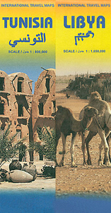
Libya - Tunisia ITMB

Libya and Tunisia at 1:1, 650, 000 and 1: 800, 000 respectively, on a double-sided, indexed road map from ITMB including street plans of Tunis and Tripoli and a glossary of geographical terms.The map displays Libya on one side and Tunisia on the other, each accompanied by its capital city plan and a separate index. Road networks include main paved, secondary and unsurfaced minor roads and tracks, with intermediate distances on major roads. Symbols clearly indicate petrol stations, international and local airports, and railways and ferry routes are also shown. Topography is represented by altitude colouring and graphics indicate deserts, swamps, salt flats, oasis, water wells and seasonal rivers, etc. Numerous spot heights are marked and mountain ranges named, and other
geographical features are present. Symbols mark locations of various places of interest including towns with tourist accommodation, campsites, historic ruins and archaeological sites, beaches, ports, etc. The map also shows gas and oil wells and pipelines. International boundaries and border crossing are marked. The map is annotated with historical and tourist information of places of interest and illustrated with colour pictures. It includes street plans of central Tunis and Tripoli and a glossary of geographical terms used on the map. The map is indexed and all place names are shown transliterated only. Latitude and longitude lines are drawn at intervals of 2°.
RIP - This product is no longer available on our network. It was last seen on 25.09.2019

This page now acts as a permanent archive for this product. Add more information using the comments box below to ensure it can still be found by future generations.

Use our search facility to see if it is available from an alternative contributor.
  • Availability: Out Of Stock
  • Supplier: Stanfords
  • SKU: 9781553413028
Availability: In Stock
£9.99

Product Description

Libya & Tunisia at 1:1, 650, 000 & 1: 800, 000 respectively, on a double-sided, indexed road map from ITMB including street plans of Tunis & Tripoli & a glossary of geographical terms. The map displays Libya on one side & Tunisia on the other, each accompanied by its capital city plan & a separate index. Road networks include main paved, secondary & unsurfaced minor roads & tracks, with intermediate distances on major roads. Symbols clearly indicate petrol stations, international & local airports, & railways & ferry routes are also shown. Topography is represented by altitude colouring & graphics indicate deserts, swamps, salt flats, oasis, water wells & seasonal rivers, etc. Numerous spot heights are marked & mountain ranges named, & other geographical features are present. Symbols mark locations of various places of interest including towns with tourist accommodation, campsites, historic ruins & archaeological sites, beaches, ports, etc. The map also shows gas & oil wells & pipelines. International boundaries & border crossing are marked. The map is annotated with historical & tourist information of places of interest & illustrated with colour pictures. It

Includes::
street plans of central Tunis & Tripoli & a glossary of geographical terms used on the map. The map is indexed & all place names are shown transliterated only. Latitude & longitude lines are drawn at intervals of 2°.

Reviews/Comments

Add New

Intelligent Comparison

Oooops!
We couldn't find anything!
Perhaps this product's unique.... Or perhaps we are still looking for comparisons!
Click to bump this page and we'll hurry up.

Price History

Vouchers

No voucher codes found.
Do you know a voucher code for this product or supplier? Add it to Insights for others to use.

Facebook

Jargon Buster

Oil - A hydrophobic liquid with high carbon and hydrogen content. Has many variations including; cooking oils, petrochemical oils, essential oils.
water - A chemical substance. Chemical formula H2O.
Graphics - A general term for visual aspects of an item/display
Railways - A set of tracks that have been laid for the purpose of trains to travel up and down them
Colour - The categorised spectrum of light visable to humans
Road - a manmade lane or a path that is used to speed up travel.
Altitude - Something that can be quite high in relation to sea or ground level.
Accommodation - A room in which someone can live in, for example in a hotel

Supplier Information

Stanfords
Stanfords was established in 1853 and opened their iconic Covent Garden flagship store in 1901. They have become the top retailer of maps, travel books and accessories in the UK and arguably offer the largest selection of maps and travel books worldwide. Famous names such as Captain Robert Falcon Scott, Ranulph Fiennes and Michael Palin have purchased from Stanfords. They now have a shop in Bristol and both stores together with other venues operate a calendar of events including talks, book signings and exhibitions. As a specialist map retailer, the map selection is comprehensive and includes road maps, street maps and walking maps from worldwide destinations, as well as a selection of world atlases and wall maps. Books include travel guides and travel literature. Stanfords also stock globes, from miniatures made of blue marble to magnificent floor-standing globes. The website features a selection of interesting articles on travel topics.
Page Updated: 2023-11-12 20:15:36

Community Generated Product Tags

Oh No! The productWIKI community hasn't generated any tags for this product yet!
Menu