
 United Kingdom
 France
 Germany
 Netherlands
 Sweden
 USA
USA
 Italy
Italy
 Spain
Spain
More From Contributor


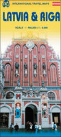
Latvia & Riga ITMB
Road map of Latvia at 1:460, 000 with street plans of Riga at 1:8, 000 and its Old Town in greater detail at 1:4, 000, plus an enlargement of the capital’s environs on a double-sided map from ITMB.On one side is the plan of Riga, indexed, highlighting locations of numerous hotels, restaurants, cultural institutions, etc. Tram, bus and trolleybus routes are shown with stops and line numbers. The Vecriga, the capital’s Old Town and a UNESCO World heritage site, is shown in greater detail on a large inset at 1:4, 000. ITMB acknowledges the contribution of the Latvian publishers Jana Seta (well represented on Stanfords’ website) in preparation of this plan. Also provided is a diagram of the city’s tram routes and a road map of Riga’s environs at 1:300, 000.On the reverse is
an indexed map at 1:460, 000 showing Latvia’s road and rail networks. National parks and numerous nature reserves are highlighted. The map has latitude and longitude lines are drawn at 30’ intervals.
an indexed map at 1:460, 000 showing Latvia’s road and rail networks. National parks and numerous nature reserves are highlighted. The map has latitude and longitude lines are drawn at 30’ intervals.

Product Description
Reviews/Comments
Add New
Vouchers
No voucher codes found.
Do you know a voucher code for this product or supplier? Add it to Insights for others to use.
Do you know a voucher code for this product or supplier? Add it to Insights for others to use.
 Denmark