
 United Kingdom
 France
 Germany
 Netherlands
 Sweden
 USA
USA
 Italy
Italy
 Spain
Spain
More From Contributor
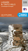


Lanark And Upper Nithsdale
Map No. 71, Lanark and Upper Nithsdale, in the Ordnance Survey Landranger series at 1:50, 000, including Cumnock, Darvel, Caldermill, Drumclog, Strathaven, Blackwood, Lesmahagow, Coalburn, Douglas, Roberton, Glespin, Muirkirk, Sorn, Crawfordjohn, Abington, Wanlockhead, Dalblair, New Cumnock, Lirkconnel and Sanquhar, with the Tinto Hills, Lowther Hills, Glen Afton, the peaks of Enoch Hill, Blackcraig Hill, Kirkland Hill, Wellgrain Dod, Cairn Table, Wardlow Hill and Blackside, Glenbuck Loch, Logan Reservoir, Glengavel Reservoir, and the Southern Upland Way. Edition B3; Publication Date: June 2011 This title is also available on our website in a waterproof and tear-resistant version.Maps in this series are only published folded. Stanfords can also print flat
versions of Ordnance Survey maps through the OS Select system, centring the map on a location of your choice and with a picture provided by you on the cover. For more information please click on the link at the bottom of this description.About Ordnance Survey
versions of Ordnance Survey maps through the OS Select system, centring the map on a location of your choice and with a picture provided by you on the cover. For more information please click on the link at the bottom of this description.About Ordnance Survey
Product Description
Reviews/Comments
Add New
Intelligent Comparison
Archived Product
Lanark And Upper Nithsdale WATERPROOF Stanfords
£10.39
Archived Product
Lanark And Upper Nithsdale OS ACTIVE Map Stanfords
£9.09
Vouchers
No voucher codes found.
Do you know a voucher code for this product or supplier? Add it to Insights for others to use.
Do you know a voucher code for this product or supplier? Add it to Insights for others to use.
 Denmark