
 United Kingdom
 France
 Germany
 Netherlands
 Sweden
 USA
USA
 Italy
Italy
 Spain
Spain
More From Contributor


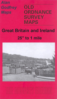
Lamberhead Green And Orrell Mount 1907
Lamberhead Green and Orrell Mount in 1907 in a fascinating series of reproductions of old Ordnance Survey plans in the Alan Godfrey Editions, ideal for anyone interested in the history of their neighbourhood or family. The map covers the western part of Pemberton, including Lamberhead Green, and parts of Orrell and Winstanley. Coverage stretches from Enfield Street westward to Orrell station and from Orrell Mount southward to Rylance Mill. Features include a stretch of the Lancashire & Yorkshire Railway (Orrell station is split by the west margin), Winstanley Colliery Railway, Favourite Pony Dick inn, Rylance Mill, moat of Winstanley Hall, Orrell Brick Works, Edge Wood Hall, Orrell Mount, Orrell Council Offices, Orrell Lodge, St John`s church, Lamberhead Green area, St
Matthew`s church Highfield (split by east margin), Rose Hill area, tramways and depot, Duke`s Woods, old shafts, Highfield Farm, Highfield House, Sumner`s Hall, Pingot House, etc. On the reverse is a directory of Orrell in 1918.About the Alan Godfrey Editions of the 25” OS Series:Selected towns in Great Britain and Ireland are covered by maps showing the extent of urban development in the last decades of the 19th and early 20th century. The plans have been taken from the Ordnance Survey mapping and reprinted at about 15 inches to one mile (1:4, 340). On the reverse most maps have historical notes and many also include extracts from contemporary directories. Most maps cover about one mile (1.6kms) north/south, one and a half miles (2.4kms) across; adjoining sheets can be
combined to provide wider coverage.FOR MORE INFORMATION AND A COMPLETE LIST OF ALL AVAILABLE TITLES PLEASE CLICK ON THE SERIES LINK.

Product Description
Reviews/Comments
Add New
Vouchers
No voucher codes found.
Do you know a voucher code for this product or supplier? Add it to Insights for others to use.
Do you know a voucher code for this product or supplier? Add it to Insights for others to use.
 Denmark