More From Contributor

£13.99
Lake Geneva
- Chablais
- Faucigny area of the French Alps at 1:60, 000 on a contoured & GPS compatible map from Didier Richard

...
Archived Product
£10.99
Selected tourist regions of the France on GPS compatible, contoured TOP 75 maps at 1:75, 000 from the IGN, highlighting local & long-distance hiking paths, cycling routes & sites for other recreational activities. Each title

Includes::
five large panels with mapping at 1:25, 000 to cover its most popular areas in greater detail. Cartography of the main map at 1:75, 000 is a direct enlargement of the mapping used in the IGN’s TOP100 series. Contours are at 40m intervals, enhanced by relief shading; additional colouring shows different types of vegetation (woods, brushwood, vineyards/orchards). Boundaries of national parks & other protected areas are marked. An overprint highlights long-distance GR hiking routes & cycling trails. Symbols
- more numerous than on the TOP100 maps
- indicate various places of interest including mountain refuges & gîtes d’etape (but not campsites, see below), areas for other recreational pursuits such as climbing, hand gliding or water & winter sports, historic or cultural sites, etc. The maps have a UTM grid & an index of communes. Map legend

Includes::
English. Each title also contains five enlargements of popular areas which benefit from presentation at a more detailed scale of 1:25, 000. These are extracts from IGN’s topographic survey maps & in addition to the GR routes also highlight local hiking paths & provide more information on tourist facilities including campsites.


...
Archived Product
£10.95
Lake Geneva to Mont-Blanc area in a series of GPS compatible, contoured TOP75 maps at 1:75, 000 from the IGN, highlighting GR routes, cycling trails & sites for other recreational activities. Enlargements at 1:25, 000 are included in each map. Cartography of the main map at 1:75, 000 is a direct enlargement of the mapping used in the IGN ...
Archived Product
£9.95
Lake Llanquihue & Surrounding Region at 1:150, 000/1:50, 000 in a series of contoured, GPS compatible trekking & exploration maps at various scales form Trekkingchile. The maps are annotated with tourist information & most titles include a street plan of the region ...
Archived Product
£11.99
Lake Llanquihue & Surrounding Region at 1:150, 000/1:50, 000 on a waterproof & tear-resistant map in a series of contoured, GPS compatible trekking & exploration maps at various scales form Trekkingchile. The main map at 1:150, 000 covers the lake & the area to the east of it, extending south to Puerto Montt. Contours are at 100m intervals. Road network

Includes::
4WD tracks & local paths. Symbols highlight various accommodation facilities (hotels, B& Bs, cabins, campsites, refuges), sport & recreational sites, various tourist services & facilities, etc. The map has a UTM grid, plus margin ticks for latitude & longitude at 20’ & 10’ respectively. On the reverse the principal trekking areas are shown in greater detail at 1:50, 000: Volcán Calbuco, Volcán Osorno & the trek between Lago Rupanco, & Lago Todos los Santos. Also provided is a street plan highlighting main tourist facilities in Puerto Varas. Maps in the Trekkingchile series use satellite imagery as a base, with contour lines & colouring to indicate different types of terrain & habitats. Unless indicated to the contrary in the individual descriptions, the maps have a UTM grid, plus margin ticks for latitude & longitude. The maps are annotated with tourist information & most titles include a street plan of the region’s main town. Many are illustrated with drawings of local fauna or flora. Map legends & other text include English. To see the other titles in this series please click on the series link.

...
Archived Product
£10.50
Lake Louise
- Yoho in a series of detailed hiking maps of the Canadian Rockies, covering the most popular areas of the Banff,
...
Archived Product
£14.95
Lake Louise
- Yoho area at 1:50, 000 on a waterproof & tear-resistant map in a series from Gem Trek covering the most visited
...
Archived Product
£19.99
Lake Lucerne area at 1:50, 000 in a series from Hallwag covering Switzerland’s popular hiking regions on light, waterproof & tear-resistant maps highlighting long-distance paths: the nine national routes plus special regional routes, as well as other local hiking trails. Cartography is similar to that used both in Hallwag’s hiking atlases & in the walking series from Kümmerly + Frey at 1:60, 000 covering the whole country. The maps have contours at 50m or 25m intervals according to the terrain, enhanced by graphic relief & shading. A special feature of this series is an overprint indicating the nine national long-distance routes, plus regional long-distance trails. The overprint also shows other local paths, distinguishing between sign-posted hiking paths, mountain paths where proper walking shoes are necessary, & alpine paths requiring special equipment for glacier traverses & light climbing. Mountain huts are marked, plus various types of accommodation: campsites, youth hostels, “ Friends of Nature” houses, & secluded hotels & restaurants. Road network indicates local bus routes with stops. Railways, narrow gauge mountain railways, cable car lines, & chair lifts are shown, with various symbols highlighting places of interest, viewpoints, picnic sites, swimming pools, etc. The maps have a 1km grid for Swiss national coordinates (datum CH1903 Bessel), with latitude & longitude shown as margin ticks at 5’. * Map legend

Includes::
English.* On the reverse, an index of towns & villages

Includes::
names of geographical features such as mountains, alpine passes, glaciers, lakes, rivers, as well as places of interest. Also provided is a small road map at 1:301, 000 of a wider region around the area covered by each title.of interest. Also provided is a road map at 1:301, 000 of a wider region around the area covered by each title.* In this title:* four national routes, Via Alpina (1), Trans Swiss Trail (2), Alpine Panorama Route (3), & Via Jacobi (4), plus seven regional routes: Pragelpass Route (29), Via Sbrinz (40), Obwaldner High Route (57), Schwyzer High Route (63), Via Gottardo (77), Nidwaldner High Route (88) & Weg der Schweiz (99)


...
Archived Product
£19.99
Lake Lucerne (Vierwaldstättersee) area at 1:60, 000 in Kümmerly + Frey’s hiking series of Switzerl&, with most titles now printed on light, waterproof & tear-resistant plastic paper. The series offers a popular alternative to Swiss survey maps & cartography which many walkers find easier to follow. Coverage of the whole country is designed so that each title presents a popular hiking area. The maps have contours at 50 or 25-metre intervals according to the terrain, enhanced by graphic relief & shading. An overprint distinguishes between sign-posted hiking paths, mountain path where proper walking shoes are necessary, & alpine paths requiring special equipment. Most titles now also indicate national & regional long-distance hiking routes, each annotated with its official number. Mountain huts are marked, plus various types of accommodation: campsites, youth hostels, “ Friends of Nature” houses, & secluded hotels & restaurants. Road network indicates local bus routes with stops. Railways, narrow gauge mountain railways, cable car lines, & chair lifts are shown, with various symbols highlighting places of interest, viewpoints, picnic sites, swimming pools, etc. Each title covers an area of Approx. 60 x 42 km (37 x 26 miles). The maps have a 1km Swiss national grid, plus latitude & longitude margin ticks at 5’ intervals. * Map legend

Includes::
English.* On the reverse, an index of towns & villages

Includes::
names of geographical features such as mountains, alpine passes, glaciers, lakes, rivers, as well as places of interest. Also provided is an overview road map of surrounding region.


...
Archived Product
£20.99
Lake Lucerne area, map No. 5008, in the standard topographic survey of Switzerland at 1:50, 000 from Swisstopo, i.e. without the special overprint highlighting walking trails, local bus stops, etc, presented in Swisstopo’s hiking editions of the 50K survey. Highly regarded for their superb use of graphic relief & hill shading, the maps give an almost 3-D picture of Switzerland`s mountainous terrain. Contours are at 20m intervals. All the maps have a 1-km grid with the Swiss national coordinates. This standard version of the 50K survey covers the whole country on 78 small format sheets, with special larger format maps published for several popular tourist destinations. Small format sheets cover an area of 35 x 24 km (21 x 15 miles approx) & have map legend in the language of the area covered by the map. The special larger sheets cover 50 x 35 km (31 x 22 miles approx) & have no map legend, but a separate leaflet can be provided instead.PLEASE NOTE: the hiking editions of the 1:50, 000 Swisstopo survey are listed on our website in a separate series. ...
Archived Product

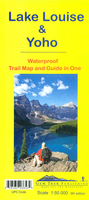
Lake Louise & Yoho Gem Trek Map

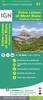
Lake Louise - Yoho area at 1:50, 000 on a waterproof and tear-resistant map in a series from Gem Trek covering the most visited parts of the Banff, Jasper, Kootenay and Yoho National Parks, as well as Waterton Lakes NP further south and the adjoining Goat Haunt area of Montana. The map covers the Lake Louise area of the Banff NP and the adjoining parts of the Yoho NP with Lake O’Hara. Contours are at 25m intervals, enhanced by relief shading plus coloring and/or graphics for rock/alpine areas, tree cover, glaciers, etc. Spot heights are in metres and feet. Extensive overprint highlights hiking and/or mountain biking trails, different types of tourist accommodation, riding stables, canoe rentals, etc. The map has a 1-km UTM grid and margin ticks at 5’. On the reverse
enlargements at 1:25, 000 show the Lake Louise - Chateau Lake Louise and the Lake O`Hara areas in greater detail. The rest of the reverse side is covered by extensive notes with descriptions of 28 recommended hiking trails, including where appropriate accommodation details, access by public transports, etc. Also included is more general information about the area and its facilities.To see the list of titles in this series please click on the series link.
RIP - This product is no longer available on our network. It was last seen on 25.09.2019

This page now acts as a permanent archive for this product. Add more information using the comments box below to ensure it can still be found by future generations.

Use our search facility to see if it is available from an alternative contributor.
  • Availability: Out Of Stock
  • Supplier: Stanfords
  • SKU: 9781895526875
Availability: In Stock
£14.99

Product Description

Lake Louise
- Yoho area at 1:50, 000 on a waterproof & tear-resistant map in a series from Gem Trek covering the most visited parts of the Banff, Jasper, Kootenay & Yoho National Parks, as well as Waterton Lakes NP further south & the adjoining Goat Haunt area of Montana. The map covers the Lake Louise area of the Banff NP & the adjoining parts of the Yoho NP with Lake O’ Hara. Contours are at 25m intervals, enhanced by relief shading plus coloring and/or graphics for rock/alpine areas, tree cover, glaciers, etc. Spot heights are in metres & feet. Extensive overprint highlights hiking and/or mountain biking trails, different types of tourist accommodation, riding stables, canoe rentals, etc. The map has a 1-km UTM grid & margin ticks at 5’. On the reverse enlargements at 1:25, 000 show the Lake Louise
- Chateau Lake Louise & the Lake O` Hara areas in greater detail. The rest of the reverse side is covered by extensive notes with descriptions of 28 recommended hiking trails, including where appropriate accommodation details, access by public transports, etc. Also included is more general information about the area & its facilities. To see the list of titles in this series please click on the series link.

Reviews/Comments

Add New

Intelligent Comparison

Oooops!
We couldn't find anything!
Perhaps this product's unique.... Or perhaps we are still looking for comparisons!
Click to bump this page and we'll hurry up.

Price History

Vouchers

No voucher codes found.
Do you know a voucher code for this product or supplier? Add it to Insights for others to use.

Facebook

Jargon Buster

Hiking - An outdoor activity envolving walking in nature
Metres - A unit of measure, one metre equals 100 centimetres
Graphics - A general term for visual aspects of an item/display
Waterproof - Resistant to water, usualy specified by depth in metres
Km - Kilometre. A unit of measurement equal to 1000 metres.
Resistant - Something that can repel against something.
Accommodation - A room in which someone can live in, for example in a hotel

Supplier Information

Stanfords
Stanfords was established in 1853 and opened their iconic Covent Garden flagship store in 1901. They have become the top retailer of maps, travel books and accessories in the UK and arguably offer the largest selection of maps and travel books worldwide. Famous names such as Captain Robert Falcon Scott, Ranulph Fiennes and Michael Palin have purchased from Stanfords. They now have a shop in Bristol and both stores together with other venues operate a calendar of events including talks, book signings and exhibitions. As a specialist map retailer, the map selection is comprehensive and includes road maps, street maps and walking maps from worldwide destinations, as well as a selection of world atlases and wall maps. Books include travel guides and travel literature. Stanfords also stock globes, from miniatures made of blue marble to magnificent floor-standing globes. The website features a selection of interesting articles on travel topics.
Page Updated: 2023-11-12 20:15:36

Community Generated Product Tags

Oh No! The productWIKI community hasn't generated any tags for this product yet!
Menu