More From Contributor

£9.99
The environs of Kuldiga on a contoured & GPS compatible map at 1:75, 000 from the Latvian publishers Jana Seta, with detailed presentation the road or rail networks, places of interest & tourist facilities, etc. Alsunga, Kuldiga & Skrunda are also covered by street plans at 1:20, 000. Maps in this series are double-sided with a good overlap between the sides. Topography & landscape are shown by contours at 10m intervals, numerous spot heights, & colouring/graphics for different types of land use or terrain (orchards, forests, swamps, etc). Finely graded road network indicates “difficult to travel unsurfaced roads”, shows driving distances on main & secondary routes, & indicates locations of petrol stations. Railway lines are shown with stations & stops; the maps also show narrow gauge lines & abandoned routes. Interesting locations are highlighted & symbols indicate hotels & other tourist accommodation, campsites, viewpoints, hills & interesting natural sites, etc. The maps have latitude & longitude lines at 5’ & 10’ respectively. Map legend

Includes::
English. To see the other titles in this series please click on the series link.

...
Archived Product
£7.95
About the series: Maps designed specifically for the trekker, presenting the topography by line drawings of mountain ridges, with main peaks & passes shown with their height above sea level. The maps also show rivers & settlements & clearly indicate trekking routes. On the reverse are descriptions of suggested routes & other information about the area. ...
Archived Product
£9.95
About the series: Maps designed specifically for the trekker, presenting the topography by line drawings of mountain ridges, with main peaks & passes shown with their height above sea level. The maps also show rivers & settlements & clearly indicate trekking routes. On the reverse are descriptions of suggested routes & other information about the area. ...
Archived Product
£11.50
Kulmbach in a series of GPS compatible recreational editions of the Bavarian topographic survey at 1:25, 000, with waymarked hiking trails & cycling routes, campsites & youth hostels, etc. Coverage

Includes::
Stadtsteinach, Kupferberg, Marktleugast, Marktschorgast. Contours used in this map vary between 5 to 20m according to the terrain, with 20m interval predominantly used for hilly areas. Varied colouring show different types of landscape: woods, vineyards, fields etc. Maps in this series feature extensive overprint highlighting local & long-distance footpaths & cycle routes, including King Ludwig Way or different variants of the Way of St James, indicating their waymarking. Symbols highlight different types of accommodation (campsites, youth hostels, refuges, etc), sport & recreational facilities, various places of interest, etc. The maps have a 1-km UTM grid. Map legend & all the text are in German only. To see other titles in this series please click on the series link.

...
Archived Product
£17.99
The 1:50 000 topographic map gives a more general picture of the ground features than a basic map. It shows settlements, houses, roads, cultivated areas, waterways, cutting areas, mires, rock exposures, & relief. One map sheet covers an area of 30 x 40 km & one centimetre corresponds to 500 metres on the ground. The 1:50, 000 topographic map is also an ideal complement to nautical charts as it provides useful information about the land areas adjacent to waterways. For example, all Finnish sea areas are covered by 1:50 000 topographic map sheets. ...
Archived Product
£1595.00
Our Kunstkammer Console is definitely multi-functional. Constructed of solid wood in a light & dark honey finish, this cabinet features two pullout shelves for extra work space, two small drawers, & two double-height drawers. Crown molding & brass hardware accents complete the look of this elegant piece that will not only provide abundant storage, but will enhance the beauty of any of your possessions. Elegant & practical. If we do not have this item in stock we will order it for you from our supplier. Delivery generally takes 3 weeks within the UK. For overseas delivery queries please email sales@stanfords.co.uk ...
Archived Product
£17.99
The 1:50 000 topographic map gives a more general picture of the ground features than a basic map. It shows settlements, houses, roads, cultivated areas, waterways, cutting areas, mires, rock exposures, & relief. One map sheet covers an area of 30 x 40 km & one centimetre corresponds to 500 metres on the ground. The 1:50, 000 topographic map is also an ideal complement to nautical charts as it provides useful information about the land areas adjacent to waterways. For example, all Finnish sea areas are covered by 1:50 000 topographic map sheets. ...
Archived Product
£17.99
The 1:50, 000 topographic map gives a more general picture of the ground features than a basic map. It shows settlements, houses, roads, cultivated areas, waterways, cutting areas, mires, rock exposures, & relief. One map sheet covers an area of 30 x 40 km & one centimetre corresponds to 500 metres on the ground. The 1:50, 000 topographic map is also an ideal complement to nautical charts as it provides useful information about the land areas adjacent to waterways. For example, all Finnish sea areas are covered by 1:50, 000 topographic map sheets. ...
Archived Product

Kunstkammer Cabinet

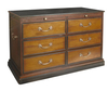
This replica cabinet has glass doors allowing you to display your books and collections. Sliding doors with large and small drawers and pull out shelves. Elegant crown molding and on top and bottom. The unit is finished in rich honey and night sky black lacquer timber with solid brass hardware. Kunstkammers are on display at the National Museum in Munich and several other major European museums in the region. Measuring in size from diminutive cabinets with just a few drawers to cabinets that fill entire rooms, they date from the Renaissance to the Age of Enlightenment. A great addition to any room. If we do not have this item in stock we will order it for you from our supplier. Delivery generally takes 3 weeks within the UK. For overseas delivery queries please email sales@stanfords.co.uk
RIP - This product is no longer available on our network. It was last seen on 25.09.2019

This page now acts as a permanent archive for this product. Add more information using the comments box below to ensure it can still be found by future generations.

Use our search facility to see if it is available from an alternative contributor.
  • External links may include paid for promotion
  • Availability: Out Of Stock
  • Supplier: Stanfords
  • SKU: 0781934573913
Availability: In Stock
£3495.00

Product Description

This replica cabinet has glass doors allowing you to display your books & collections. Sliding doors with large & small drawers & pull out shelves. Elegant crown molding & on top & bottom. The unit is finished in rich honey & night sky black lacquer timber with solid brass hardware. Kunstkammers are on display at the National Museum in Munich & several other major European museums in the region. Measuring in size from diminutive cabinets with just a few drawers to cabinets that fill entire rooms, they date from the Renaissance to the Age of Enlightenment. A great addition to any room. If we do not have this item in stock we will order it for you from our supplier. Delivery generally takes 3 weeks within the UK. For overseas delivery queries please email sales@stanfords.co.uk

Reviews/Comments

Add New

Intelligent Comparison

Oooops!
We couldn't find anything!
Perhaps this product's unique.... Or perhaps we are still looking for comparisons!
Click to bump this page and we'll hurry up.

Price History

Vouchers

No voucher codes found.
Do you know a voucher code for this product or supplier? Add it to Insights for others to use.

Facebook

Jargon Buster

Brass - A copper and Zinc Alloy
Honey - A sweet produce made by honey bees in their hives from pollen and nectar from flowers
Black - A colour which does not emit any colour of the spectrum. Black absorbs all frequencies of the spectrum.
UK - United Kingdom - An island nation in Europe
Glass - A solid, typically transparent. Brittle and used in windows. The first patent granted in the UK was for Glass.
Date - A day on a calendar
Date - A social activity whith a current or potential partner
email - An electronic communication method. Short for Electronic Mail.
delivery - The method by which something is delivered from one location to another
Size - is the measurement of how big an object is in space.
Large - something that takes up more space than normal.
Small - something that takes up less space than normal.
Replica - A copy or duplicate of something.
Museum - A building which exhibits old artefacts for viewing of people who show interest.
Solid - Something that is firm and not liquid, a hard shape that cannot be changed easily.

Supplier Information

Stanfords
Stanfords was established in 1853 and opened their iconic Covent Garden flagship store in 1901. They have become the top retailer of maps, travel books and accessories in the UK and arguably offer the largest selection of maps and travel books worldwide. Famous names such as Captain Robert Falcon Scott, Ranulph Fiennes and Michael Palin have purchased from Stanfords. They now have a shop in Bristol and both stores together with other venues operate a calendar of events including talks, book signings and exhibitions. As a specialist map retailer, the map selection is comprehensive and includes road maps, street maps and walking maps from worldwide destinations, as well as a selection of world atlases and wall maps. Books include travel guides and travel literature. Stanfords also stock globes, from miniatures made of blue marble to magnificent floor-standing globes. The website features a selection of interesting articles on travel topics.
Page Updated: 2023-11-12 20:15:36

Community Generated Product Tags

Oh No! The productWIKI community hasn't generated any tags for this product yet!
Menu