
 United Kingdom
 France
 Germany
 Netherlands
 Sweden
 USA
USA
 Italy
Italy
 Spain
Spain
More From Contributor
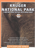

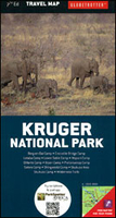
Kruger National Park
Kruger National Park at double-sided map at 1:200, 000 in the Globetrotter imprint from New Holland, with additional panels showing in detail the park’s tourist accommodation camps, plus thematic maps, entry and closing time tables, climate charts, etc. Cartography is designed to show main roads and tracks leading to accommodation areas and various places of interest rather than to present the topography in greater detail. Road network indicates untarred routes, gives driving distances and shows locations with fuel supplies and emergency repair services. Symbols indicate various places of interest and facilities including different types of accommodation. The map has no geographical coordinates.Enlargement presents in detail tourist accommodation camps: Punda Maria, Shingwedzi,
Mopani, Olifants, Letaba, Satara, Orpen, Lower Sabie, Pretoriuskop, Sukukuza, Berg-en-Dal and Crocodile Bridge. Another enlargement shows the Sukukuza area, and also provided are an overview map of north-western South Africa showing road access to the park from Johannesburg, rainfall and vegetation maps of the park, climate charts for various locations, a wilderness trails locator, tables with opening and closing times of entry gates, a distance table, plus a QR code for downloading more information.
Mopani, Olifants, Letaba, Satara, Orpen, Lower Sabie, Pretoriuskop, Sukukuza, Berg-en-Dal and Crocodile Bridge. Another enlargement shows the Sukukuza area, and also provided are an overview map of north-western South Africa showing road access to the park from Johannesburg, rainfall and vegetation maps of the park, climate charts for various locations, a wilderness trails locator, tables with opening and closing times of entry gates, a distance table, plus a QR code for downloading more information.

Product Description
Reviews/Comments
Add New
Vouchers
No voucher codes found.
Do you know a voucher code for this product or supplier? Add it to Insights for others to use.
Do you know a voucher code for this product or supplier? Add it to Insights for others to use.
 Denmark