
 United Kingdom
 France
 Germany
 Netherlands
 Sweden
 USA
USA
 Italy
Italy
 Spain
Spain
More From Contributor


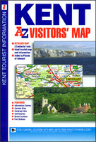
Kent A-Z Visitors` Map
Kent Visitors` Map from Geographers’ A-Z Map Company covering at 1:158, 400 (1” to 2.5 miles), prominently highlighting numerous places of interest which are also listed in an index, plus plans of the Channel Tunnel terminals at Folkestone and Calais. Coverage along the southern coast extends beyond Eastbourne to Seaford and Newhaven. Road network is shown with Primary Route Destinations prominently marked, services on motorways and major roads, locations of safety cameras with speed limits, steep gradients, etc. A wide range of symbols indicates various attractions, places of interest and facilities, which are also listed in the index of towns and villages, placed next to the map. PLEASE NOTE that unlike most maps in this Visitors’ series this title does not include street
plans. Current 27th edition of this title was published in 2015. To see the list of titles on A-Z’s Visitor’ series please click on the series link.
plans. Current 27th edition of this title was published in 2015. To see the list of titles on A-Z’s Visitor’ series please click on the series link.

Product Description
Reviews/Comments
Add New
Vouchers
No voucher codes found.
Do you know a voucher code for this product or supplier? Add it to Insights for others to use.
Do you know a voucher code for this product or supplier? Add it to Insights for others to use.
 Denmark