
 United Kingdom
 France
 Germany
 Netherlands
 Sweden
 USA
USA
 Italy
Italy
 Spain
Spain
More From Contributor


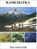

Kamchatka Krai Topographic Map
Kamchatka Peninsula with the rest of the Kamchatka Krai on double-sided topographic map at 1:1, 000, 000 from DV AGP, with an enlargement for the environs of Petropavlovsk-Kamchatsky, plus an administrative map of the region. All place names in Cyrillic and the map legend is in Russian only.The map covers the region, including the Komandorski/Commander Islands shown on an inset, at 1:1, 000, 000, dividing Kamchatka Peninsula north/south. Contours are at 100m or 200m intervals, with spot heights and additional graphics and/or colouring to show swamps, rocks, different types of forests, etc. Road network includes unsurfaced roads and tracks, indicating those passable only in winter. Internal administrative boundaries are marked and towns indicate their administrative status.
Latitude and longitude lines are drawn at 1º intervals.. All place names are in Cyrillic alphabet and map legend is in Russian only.The environs of Petropavlovsk-Kamchatsky are presented in greater detail at 1:200, 000, and another panel shows the Kamchatka Krai with their administrative subdivisions.IMPORTANT - PLEASE NOTE BEFORE ORDERING: Supplies of all maps published in Russia are very irregular and we cannot guarantee a definite delivery time for titles not in stock. If a title is currently out of stock, it may be advisable to choose an alternative publication.
Latitude and longitude lines are drawn at 1º intervals.. All place names are in Cyrillic alphabet and map legend is in Russian only.The environs of Petropavlovsk-Kamchatsky are presented in greater detail at 1:200, 000, and another panel shows the Kamchatka Krai with their administrative subdivisions.IMPORTANT - PLEASE NOTE BEFORE ORDERING: Supplies of all maps published in Russia are very irregular and we cannot guarantee a definite delivery time for titles not in stock. If a title is currently out of stock, it may be advisable to choose an alternative publication.
Product Description
Reviews/Comments
Add New
Vouchers
No voucher codes found.
Do you know a voucher code for this product or supplier? Add it to Insights for others to use.
Do you know a voucher code for this product or supplier? Add it to Insights for others to use.
 Denmark